West Walton
| West Walton | |
|---|---|
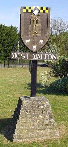
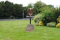 The Village sign, West Walton, Norfolk | |
 West Walton West Walton shown within Norfolk | |
| Area | 15.77 km2 (6.09 sq mi) |
| Population | 1,731 (parish, 2011 census) |
| • Density | 110/km2 (280/sq mi) |
| OS grid reference | TF4713 |
| • London | 105 miles (169 km) |
| Civil parish |
|
| District | |
| Shire county | |
| Region | |
| Country | England |
| Sovereign state | United Kingdom |
| Post town | WISBECH |
| Postcode district | PE14 |
| Dialling code | 01945 |
| Police | Norfolk |
| Fire | Norfolk |
| Ambulance | East of England |
| EU Parliament | East of England |
| UK Parliament | |
West Walton is a village and a civil parish in the English county of Norfolk.[1] The village is 56.5 miles (90.9 km) west of Norwich, 13.9 miles (22.4 km) west-south-west of King's Lynn and 105 miles (169 km) north of London and its location makes it the most westerly village in the county. The nearest town is Wisbech which is 2.6 miles (4.2 km) south of the village. The nearest railway station is at Watlington, Norfolk for the Fen Line which runs between King's Lynn and Cambridge. The nearest airport is Norwich International Airport. The parish of West Walton, in the 2001 census, had a population of 1,659, increasing to 1,731 at the 2011 census.[2] For the purposes of local government, the parish falls within the district of King's Lynn and West Norfolk.
Description
The village and parish of West Walton is located in the western part of the county of Norfolk. The western flank of the parish is also the county border between Norfolk and Cambridgeshire and is also the course of the River Nene. On the southern flank is the parish of Walsoken. To the north is Walpole and to the east is Marshland St James. The name West Walton is thought to derive from the Old English meaning of the settlement by the wall[3] which refers to the village's proximity to a Roman sea wall or defence.
History
West Walton was established by the time of the Norman Conquest. The village's population, land ownership and productive resources were detailed in its entry in the Domesday Book of 1085.[4] In the great book West Walton is recorded by the name Waltuna. The parish was held by William de Warenne with the Abbot of St peter and St Paul, Cluny from him, The Abbot of Ely before and after 1066, and Oder from Ralph de Beufour. The survey mentions ½ Church, 38 Salt Houses and 1100 sheep. the survey also records the presence of a fishery. In the Domesday survey fractions[5] were used to indicate that the entry, in this case the church, was situated within more than one parish.
Governance
West Walton is part of the electoral ward of Walton. The population of this ward at the 2011 Census was 2,641.[6]
Prominent Buildings
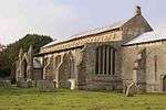
Saint Mary Parish Church
Saint Mary's dates from the 13th century built about 1240[7] and is unusual in that the church's Campanile, or Bell tower is detached some 60 feet from the main building of the church.[8] The tower is supported at its base by four open arches. At each corner stands a buttress which climb to the pinnacles with gabled niches in the first, second and third storey.[8] The tower is topped with delicately carved parapet walls. The west doorway to the church is flanked on either side by massive buttresses, a result of remedial works carried out here after the foundations failed[8] not long after the church was built. The south porch is arched with arcaded buttress on each side.[8] The nave is arcaded with six bays on each side. The arches are supported on pillars which are encircled by detached shafts crowned with capitals of stone carved foliage.[8] The hammer beamed roof dates from the 15th century and is supported by 24 carved angels holding shields.[8]
The bell tower,[9] and the church itself,[10] are both recorded in the National Heritage List for England as designated Grade I listed buildings. The bell tower is under the care of the Churches Conservation Trust.[11]
West Walton, Ingleborough towermill
Ingleborough Tower Windmill is located one mile north of the village, and is located in the yard of Hill House Farm along with a house and assorted farm buildings. The mill is now in a state of disuse.[12] It was designated as a Grade II listed building in 1951.[13]
Marshland High School, Modern language, Science, Drama and Technical areas
These areas of the school are the original 1926 buildings which provided education for the village and many others. Half of the building was Primary and the other Half Secondary. The house on the right of the building on School road was originally the caretaker’s house and was built with the school for this. There is no present data beyond the fact that due to a comprehensive system being made the schools separated to form West Walton comprehensive or as it is known today Marshland High school and West Walton community primary school around the 1950/60 area. Several extensions have been constructed over parts of the buildings hiding historical stone signage behind walls and ceilings and most of the "original" features of the building have been hidden away due to class room size changes and safety regulations. To conclude, to this day you can still see the original emblem above the classroom to the left and the original 1926 stone plaque above the classroom to the right, and may they stay there forever with the great architectural features of the building. Marshland High school is now an academy.
Gallery
 Saint Mary's parish church, West Walton
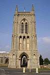 Saint Mary's Bell Tower
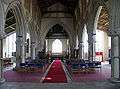 inside the church
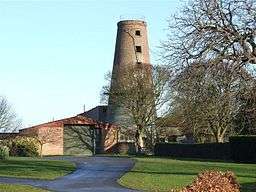 Ingleborough Tower Windmill
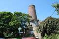 Ingleborough Tower Windmill
References
- ↑ OS Explorer Map 235(2006) – Wisbech & Peterborough North, Market Deeping & Crowland. ISBN 0-319-23807-5
- ↑ "Parish population 2011". Retrieved 30 August 2015.
- ↑ James Rye (2000). A Popular Guide to Norfolk Place-names. Larks press. ISBN 0-948400-15-3.
- ↑ The Domesday Book, Englands Heritage, Then and Now, Editor: Thomas Hinde,Norfolk page 196, West Walton, ISBN 1-85833-440-3
- ↑ The Normans in Norfolk, By Sue Margeson, Fabienne Seillier and Andrew Rogerson, Pub:1994, Page 21, ISBN 0-903101-62-9
- ↑ "Walton Ward population 2011". Retrieved 30 August 2015.
- ↑ Norfolk 2: Norfolk: North-west and South, By Nikolaus Pevsner and Bill Wilson, North Runcton entry. 0-300-09657-7
- 1 2 3 4 5 6 The King's England series, NORFOLK, by Arthur Mee,Pub:Hodder and Stoughton,1972, page 270 Saxthorpe, ISBN 0-340-15061-0
- ↑ Historic England, "Bell Tower of Church of St Mary, West Walton (1171875)", National Heritage List for England, retrieved 21 January 2016
- ↑ Historic England, "Church of St Mary, West Walton (1077676)", National Heritage List for England, retrieved 21 January 2016
- ↑ St Mary bell tower, West Walton, Norfolk, Churches Conservation Trust, retrieved 2 December 2016
- ↑ "Properties that would be perfect renovation projects". Daily Telegraph.
- ↑ Historic England. "Ingleborough Mill (1077675)". National Heritage List for England. Retrieved 19 January 2012.
External links
![]()