NP postcode area
Postcode district boundaries:
| Newport postcode area | |
|---|---|
 NP | |
| Postcode area | NP |
| Postcode area name | Newport |
| Post towns | 14 |
| Postcode districts | 25 |
| Postcode sectors | 142 |
| Postcodes (live) | 13,489 |
| Postcodes (total) | 29,669 |
| Statistics as at February 2012[1] | |
The NP postcode area, also known as the Newport postcode area,[2] is a group of postcode districts around Newport, Wales. The NP7, NP16 and NP25 districts extend across the border into England.
Coverage
The approximate coverage of the postcode districts:
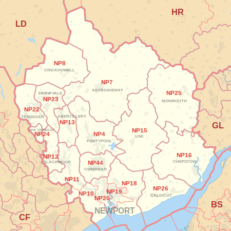
| Postcode district | Post town | Coverage | Local authority area |
|---|---|---|---|
| NP4 | PONTYPOOL | Pontypool, Blaenavon, Little Mill, Griffithstown, parts of Glascoed | Torfaen, Monmouthshire |
| NP7 | ABERGAVENNY | Abergavenny | Monmouthshire, Herefordshire |
| NP7 | CRICKHOWELL[3] | Crickhowell, Ffawyddog | Powys |
| NP8 | CRICKHOWELL | Crickhowell, Ffawyddog | Powys |
| NP10 | NEWPORT | Western Newport, including Bassaleg, Duffryn, Rogerstone | Newport |
| NP11 | NEWPORT | North-western Newport, including: Abercarn, Crumlin, Cwmfelinfach, Risca, Ynysddu | Caerphilly |
| NP12 | BLACKWOOD | Blackwood, Pontllanfraith, Wyllie | Caerphilly |
| NP13 | ABERTILLERY | Abertillery | Blaenau Gwent |
| NP15 | USK | Usk, Raglan | Monmouthshire |
| NP16 | CHEPSTOW | Chepstow, Sedbury, Beachley | Monmouthshire, Forest of Dean |
| NP18 | NEWPORT | Eastern Newport, including Caerleon, Langstone, Llanwern, Nash, Llandegveth Underwood | Newport, Monmouthshire |
| NP19 | NEWPORT | Eastern and East Central Newport, including: Beechwood, Maindee, St. Julians, Ringland | Newport |
| NP20 | NEWPORT | Western and West Central Newport, including: City centre, Pill, Maesglas, Crindau, Malpas, Bettws | Newport |
| NP22 | TREDEGAR | Tredegar, Rhymney | Blaenau Gwent, Caerphilly |
| NP23 | EBBW VALE | Ebbw Vale, Brynmawr, Cwm | Blaenau Gwent |
| NP24 | NEW TREDEGAR | New Tredegar | Caerphilly |
| NP25 | MONMOUTH | Monmouth, Wyesham, Redbrook, Welsh Newton | Monmouthshire, Forest of Dean, Herefordshire |
| NP26 | CALDICOT | Caldicot, Magor, Newport | Monmouthshire, Newport |
| NP44 | CWMBRAN | Cwmbran | Torfaen |
Map
See also
References
- ↑ "ONS Postcode Directory Version Notes" (ZIP). National Statistics Postcode Products. Office for National Statistics. February 2012. Table 2. Retrieved 21 April 2012. Coordinates from mean of unit postcode points, "Code-Point Open". OS OpenData. Ordnance Survey. February 2012. Retrieved 21 April 2012.
- ↑ Royal Mail, Address Management Guide, (2004)
- ↑ "New sectors and localities to 21 September 2012" (PDF). Royal Mail Address Management Unit. 21 September 2012. Retrieved 24 September 2012.
External links
This article is issued from
Wikipedia.
The text is licensed under Creative Commons - Attribution - Sharealike.
Additional terms may apply for the media files.