BD postcode area
Postcode district boundaries:
| Bradford postcode area | |
|---|---|
 BD | |
| Postcode area | BD |
| Postcode area name | Bradford |
| Post towns | 7 |
| Postcode districts | 27 |
| Postcode sectors | 112 |
| Postcodes (live) | 16,942 |
| Postcodes (total) | 22,544 |
| Statistics as at February 2012[1] | |
The BD postcode area, also known as the Bradford postcode area,[2] is a group of postcode districts in West Yorkshire, and North Yorkshire, around Bingley, Bradford, Cleckheaton, Keighley, Settle, Shipley and Skipton in England.
Coverage
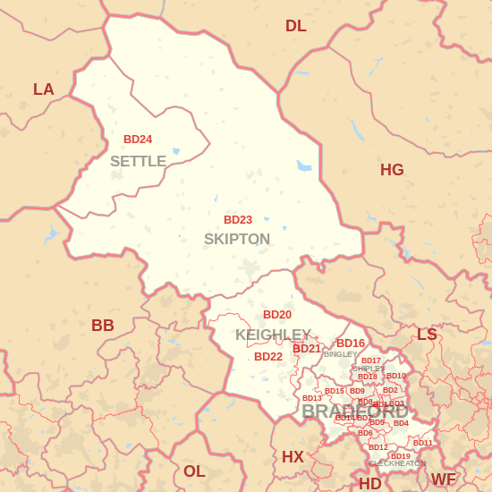
The approximate coverage of the postcode districts:
| Postcode district | Post town | Coverage | Local authority area |
|---|---|---|---|
| BD1 | BRADFORD | Bradford City Centre, Little Germany, Goitside, Longlands, Independent Quarter, West End, City Park | Bradford |
| BD2 | BRADFORD | Eccleshill, Five Lane Ends, parts of Undercliffe, Fagley, Bolton Woods, Poplars Farm, Swain House, Ashbourne, High House, Grove House | Bradford |
| BD3 | BRADFORD | Barkerend, Bradford Moor, Thornbury, Eastbrook, Pollard Park, parts of Laisterdyke, Undercliffe, Wapping | Bradford, Leeds |
| BD4 | BRADFORD | Bierley, East Bowling, East Bierley, Laisterdyke, Tong, Tong Street, Holme Wood, Dudley Hill, Tyersal, Swaine Green, Cutler Heights, Tong Village | Bradford, Leeds |
| BD5 | BRADFORD | Bankfoot, Little Horton, West Bowling, Canterbury, Marshfields, Ripleyville, | Bradford |
| BD6 | BRADFORD | Buttershaw, Wibsey, Woodside, Westwood Park, Odsal, Staithgate, parts of Horton Bank Top (Cooperville) | Bradford |
| BD7 | BRADFORD | Great Horton, Lidget Green, Scholemoor, Horton Bank Top, Horton Grange | Bradford |
| BD8 | BRADFORD | Manningham, Girlington, White Abbey, Four Lane Ends, Whetley, Westbourne Green, West Park, Lower Grange, Rhodesway, Crossley Hall, Fairweather Green, Belle Vue | Bradford |
| BD9 | BRADFORD | Frizinghall, Heaton, Daisy Hill, Haworth Road Estate, Chellow Heights, Chellow Grange | Bradford |
| BD10 | BRADFORD | Apperley Bridge, parts of Eccleshill, Greengates, Idle, Ravenscliffe, Thackley, Thorpe Edge | Bradford, Leeds |
| BD11 | BRADFORD | Birkenshaw, Drighlington | Kirklees, Leeds |
| BD12 | BRADFORD | Low Moor, Oakenshaw, Wyke, Lower Wyke, Delph Hill | Bradford, Kirklees |
| BD13 | BRADFORD | Cullingworth, Clayton Heights Denholme, Queensbury, Thornton, School Green | Bradford |
| BD14 | BRADFORD | Clayton | Bradford |
| BD15 | BRADFORD | Allerton, Norr, Wilsden, Sandy Lane | Bradford |
| BD16 | BINGLEY | Bingley, Cottingley, Eldwick, Harden | Bradford |
| BD17 | SHIPLEY | Baildon, Shipley | Bradford |
| BD18 | SHIPLEY | Saltaire, Shipley, Windhill, Wrose | Bradford |
| BD19 | CLECKHEATON | Cleckheaton, Gomersal, Scholes | Kirklees |
| BD20 | KEIGHLEY | Cononley, Cross Hills, Glusburn, Kildwick, Silsden, Steeton, Sutton-in-Craven | Bradford, Craven |
| BD21 | KEIGHLEY | Hainworth, Keighley | Bradford |
| BD22 | KEIGHLEY | Cowling, Haworth, Oakworth, Oxenhope, Cross Roads | Bradford |
| BD23 | SKIPTON | Carleton-in-Craven, Embsay, Gargrave, Grassington, Hebden, Hellifield, Horton, Kettlewell, Kirkby Malham, Skipton, Threshfield, Tosside | Craven, Harrogate, Ribble Valley |
| BD24 | SETTLE | Giggleswick, Horton in Ribblesdale, Settle | Craven |
| BD97 | BINGLEY | non-geographic | |
| BD98 | BRADFORD, SHIPLEY | non-geographic | |
| BD99 | BRADFORD | Euroway Trading Estate M606 | non-geographic |
Map
See also
References
- ↑ "ONS Postcode Directory Version Notes" (ZIP). National Statistics Postcode Products. Office for National Statistics. February 2012. Table 2. Retrieved 21 April 2012. Coordinates from mean of unit postcode points, "Code-Point Open". OS OpenData. Ordnance Survey. February 2012. Retrieved 21 April 2012.
- ↑ Royal Mail, Address Management Guide, (2004)
External links
This article is issued from
Wikipedia.
The text is licensed under Creative Commons - Attribution - Sharealike.
Additional terms may apply for the media files.