WV postcode area
Postcode district boundaries:
| Wolverhampton postcode area | |
|---|---|
 WV | |
| Postcode area | WV |
| Postcode area name | Wolverhampton |
| Post towns | 4 |
| Postcode districts | 16 |
| Postcode sectors | 58 |
| Postcodes (live) | 9,453 |
| Postcodes (total) | 12,893 |
| Statistics as at February 2012[1] | |
The WV postcode area, also known as the Wolverhampton postcode area,[2] is a group of sixteen postcode districts in England, which are subdivisions of four post towns. These postcode districts cover Wolverhampton, Willenhall and Bilston in the West Midlands, plus parts of south-west Staffordshire and south-east Shropshire (including Bridgnorth).
Mail for this area is sorted at the North West Midlands Mail Centre in Wolverhampton.
Coverage
The approximate coverage of the postcode districts:
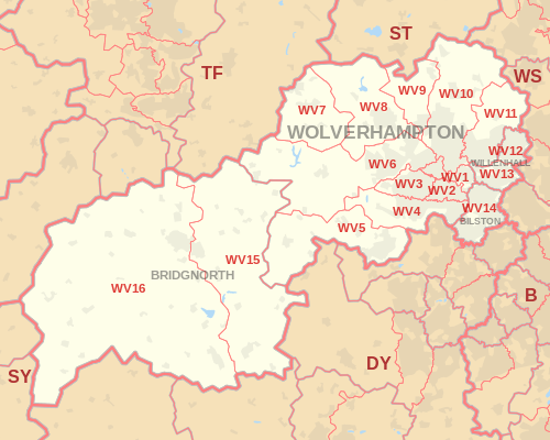
| Postcode district | Post town | Coverage | Local authority area |
|---|---|---|---|
| WV1 | WOLVERHAMPTON | Wolverhampton City Centre, Horseley Fields, East Park | Wolverhampton |
| WV1 | WILLENHALL | PO Boxes | non-geographic[3][4] |
| WV2 | WOLVERHAMPTON | All Saints, Blakenhall, Parkfields | Wolverhampton |
| WV3 | WOLVERHAMPTON | Finchfield, Compton, Castlecroft | Wolverhampton |
| WV4 | WOLVERHAMPTON | Penn, Warstones, Merry Hill, parts of Goldthorn Park and Parkfields | Wolverhampton |
| WV5 | WOLVERHAMPTON | Wombourne | South Staffordshire |
| WV6 | WOLVERHAMPTON | Whitmore Reans, Perton, Pattingham, Tettenhall | Wolverhampton, South Staffordshire |
| WV7 | WOLVERHAMPTON | Albrighton | Shropshire |
| WV8 | WOLVERHAMPTON | Codsall, Pendeford, Rakegate, Bilbrook | South Staffordshire, Wolverhampton |
| WV9 | WOLVERHAMPTON | Pendeford, Coven | Wolverhampton, South Staffordshire |
| WV10 | WOLVERHAMPTON | Low Hill, Bushbury, Heath Town, Fordhouses, Fallings Park, Featherstone, parts of Wednesfield and Brinsford | Wolverhampton |
| WV11 | WOLVERHAMPTON | Wednesfield | Wolverhampton |
| WV12 | WILLENHALL | Short Heath, Lodge Farm | Wolverhampton, Walsall |
| WV13 | WILLENHALL | Shepwell Green, Willenhall Town | Wolverhampton, Walsall |
| WV14 | BILSTON | Bradley, Bilston Town, Coseley | Wolverhampton, Dudley |
| WV15 | BRIDGNORTH | Bridgnorth (Low Town) | Shropshire |
| WV16 | BRIDGNORTH | Bridgnorth (High Town), Ditton Priors | Shropshire |
| WV98 | WOLVERHAMPTON | Jobcentre Plus | non-geographic |
| WV99 | WOLVERHAMPTON | Jobcentre Plus | non-geographic |
Map
See also
References
- ↑ "ONS Postcode Directory Version Notes" (ZIP). National Statistics Postcode Products. Office for National Statistics. February 2012. Table 2. Retrieved 21 April 2012. Coordinates from mean of unit postcode points, "Code-Point Open". OS OpenData. Ordnance Survey. February 2012. Retrieved 21 April 2012.
- ↑ Royal Mail, Address Management Guide, (2004)
- ↑ "Non Geographic Codes" (PDF). Royal Mail Address Management Unit. July 2012. Archived from the original (PDF) on 16 September 2012. Retrieved 25 October 2012.
- ↑ "New sectors and localities to 19 October 2012" (PDF). Royal Mail Address Management Unit. 19 October 2012. Archived from the original (PDF) on 13 May 2013. Retrieved 25 October 2012.
External links
This article is issued from
Wikipedia.
The text is licensed under Creative Commons - Attribution - Sharealike.
Additional terms may apply for the media files.