SY postcode area
Postcode district boundaries:
| Shrewsbury postcode area | |
|---|---|
 SY | |
| Postcode area | SY |
| Postcode area name | Shrewsbury |
| Post towns | 32 |
| Postcode districts | 26 |
| Postcode sectors | 86 |
| Postcodes (live) | 14,284 |
| Postcodes (total) | 16,559 |
| Statistics as at February 2012[1] | |
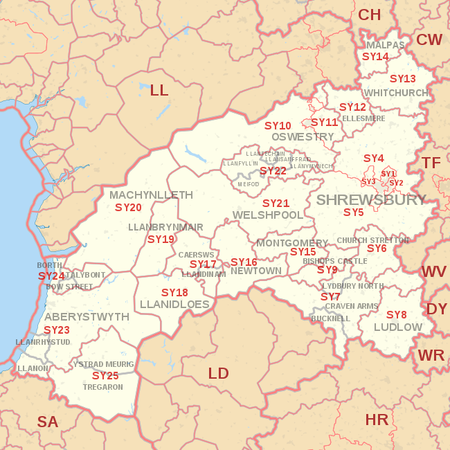
The SY postcode area, also known as the Shrewsbury postcode area,[2] is a group of postcode districts primarily around Shrewsbury, but also covering Aberystwyth, Bishop's Castle, Borth, Bow Street, Bucknell, Caersws, Church Stretton, Craven Arms, Ellesmere, Llanbrynmair, Llandinam, Llanfechain, Llanfyllin, Llanidloes, Llanon, Llanrhystud, Llansanffraid, Llanymynech, Ludlow, Lydbury North, Machynlleth, Malpas, Meifod, Montgomery, Newtown, Oswestry, Talybont, Tregaron, Welshpool, Whitchurch and Ystrad Meurig. Despite being centred on the large English town of Shrewsbury, more than half of the postcode area is in Wales.
Coverage
The SY postcode area covers a geographically large area, stretching from the western West Midlands to the Cambrian coast. In England it covers a large part of Shropshire and small parts of Cheshire and Herefordshire, and in Wales it covers large parts of Ceredigion and Powys.
The approximate coverage of the postcode districts:
| Postcode district | Post town | Coverage | Local authority area |
|---|---|---|---|
| SY1 | SHREWSBURY | Shrewsbury (north and town centre) | Shropshire |
| SY2 | SHREWSBURY | Shrewsbury (east) | Shropshire |
| SY3 | SHREWSBURY | Shrewsbury (south and west), Bayston Hill | Shropshire |
| SY4 | SHREWSBURY | Baschurch, Bomere Heath, Nesscliffe, Shawbury, Wem | Shropshire |
| SY5 | SHREWSBURY | Atcham, Cressage, Criggion, Condover, Minsterley, Pontesbury, Ratlinghope, Westbury, Wroxeter | Shropshire, Powys |
| SY6 | CHURCH STRETTON | Church Stretton, Cardington | Shropshire |
| SY7 | BUCKNELL, CRAVEN ARMS, LYDBURY NORTH | Craven Arms, Clun Valley, Diddlebury, Leintwardine, Lingen, Munslow, Tugford | Shropshire, Herefordshire |
| SY8 | LUDLOW | Ludlow, Brimfield, Clee Hill, Culmington, Leinthall Starkes, Richard's Castle, Stoke St. Milborough | Shropshire, Herefordshire |
| SY9 | BISHOPS CASTLE | Bishop's Castle, Wentnor | Shropshire |
| SY10 | OSWESTRY | Oswestry (outskirts), Gobowen, Llansilin, Llangedwyn, Llanrhaeadr-ym-Mochnant, Pen-y-bont-fawr, Llanwddyn | Shropshire, Powys |
| SY11 | OSWESTRY | Oswestry (most of), St Martin's, West Felton | Shropshire |
| SY12 | ELLESMERE | Ellesmere, Dudleston Heath (Criftins), Welshampton, Lyneal, Colemere, Cockshutt, English Frankton, Tetchill, Hordley, Bagley | Shropshire |
| SY13 | WHITCHURCH | Whitchurch | Shropshire |
| SY14 | MALPAS | Malpas, Tilston, No Man's Heath, Bickley, Hampton, Shocklach, Bulkeley, Bickerton, Cuddington Heath, Cholmondeley, Threapwood, Barton, Duckington | Cheshire West and Chester, Cheshire East, Wrexham |
| SY15 | MONTGOMERY | Montgomery, Abermule, Chirbury, Church Stoke | Powys, Shropshire |
| SY16 | NEWTOWN | Newtown, Tregynon, Bettws Cedewain | Powys |
| SY17 | CAERSWS, LLANDINAM | Caersws, Llandinam, Trefeglwys, Carno, Llanwnnog, Pontdolgoch, Clatter | Powys |
| SY18 | LLANIDLOES | Llanidloes, Llangurig, Van, Tylwch | Powys |
| SY19 | LLANBRYNMAIR | Llanbrynmair, Llan, Bont Dolgadfan, Dolfach, Talerddig, Staylittle, Pennant, Dylife | Powys |
| SY20 | MACHYNLLETH | Machynlleth, Corris | Powys, Gwynedd |
| SY21 | WELSHPOOL | Welshpool, Marton, Stockton | Powys, Shropshire |
| SY22 | LLANFECHAIN, LLANFYLLIN, LLANSANTFFRAID, LLANYMYNECH, MEIFOD | Llanfechain, Llanfyllin, Llansantffraid-ym-Mechain, Llanymynech, Meifod | Powys |
| SY23 | ABERYSTWYTH, LLANON, LLANRHYSTUD | Aberystwyth, Llanbadarn Fawr, Penparcau, Llanon, Llanrhystud | Ceredigion |
| SY24 | BORTH, BOW STREET, TALYBONT | Borth, Bow Street, Pen-y-garn, Rhydypennau, Llandre, Talybont | Ceredigion |
| SY25 | YSTRAD MEURIG, TREGARON | Ystrad Meurig, Tregaron | Ceredigion |
| SY99 | SHREWSBURY | Jobcentre Plus | non-geographic |
Map
See also
References
- ↑ "ONS Postcode Directory Version Notes" (ZIP). National Statistics Postcode Products. Office for National Statistics. February 2012. Table 2. Retrieved 21 April 2012. Coordinates from mean of unit postcode points, "Code-Point Open". OS OpenData. Ordnance Survey. February 2012. Retrieved 21 April 2012.
- ↑ Royal Mail, Address Management Guide, (2004)