PO postcode area
Postcode district boundaries:
| Portsmouth postcode area | |
|---|---|
 PO | |
| Postcode area | PO |
| Postcode area name | Portsmouth |
| Post towns | 24 |
| Postcode districts | 34 |
| Postcode sectors | 130 |
| Postcodes (live) | 23,806 |
| Postcodes (total) | 31,316 |
| Statistics as at February 2012[1] | |
The PO postcode area, also known as the Portsmouth postcode area,[2] is a group of postcode districts in Hampshire, West Sussex, and the Isle of Wight in southern England.
Coverage
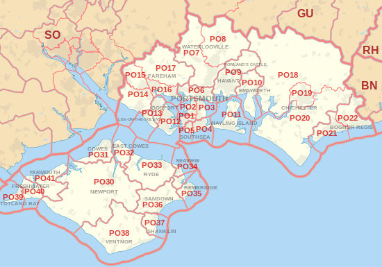
The approximate coverage of the postcode districts:
| Postcode district | Post town | Coverage | Local authority area |
|---|---|---|---|
| PO1 | PORTSMOUTH | Portsmouth, Fratton, Old Portsmouth, Portsea, Landport | Portsmouth |
| PO2 | PORTSMOUTH | Portsmouth, Hilsea, North End, Tipner, Stamshaw | Portsmouth |
| PO3 | PORTSMOUTH | Portsmouth, Hilsea, Baffins, Copnor, Anchorage Park | Portsmouth |
| PO4 | SOUTHSEA | Southsea, Milton, Eastney | Portsmouth |
| PO5 | SOUTHSEA | Southsea | Portsmouth |
| PO6 | PORTSMOUTH | Paulsgrove, Cosham, Drayton, Farlington | Portsmouth |
| PO7 | WATERLOOVILLE | Waterlooville, Denmead, Purbrook | Havant, Winchester |
| PO8 | WATERLOOVILLE | Clanfield, Cowplain, Horndean | Havant, East Hampshire |
| PO9 | HAVANT | Havant | Havant |
| PO9 | ROWLAND'S CASTLE | Rowland's Castle | East Hampshire, Havant |
| PO10 | EMSWORTH | Emsworth, Southbourne, Westbourne | Havant |
| PO11 | HAYLING ISLAND | Hayling Island | Havant |
| PO12 | GOSPORT | Gosport, Alverstoke, Hardway | Gosport |
| PO12 | LEE-ON-THE-SOLENT | Gosport | non-geographic[3][4] |
| PO13 | GOSPORT | Gosport | Gosport |
| PO13 | LEE-ON-THE-SOLENT | Lee-on-the-Solent | Gosport |
| PO14 | FAREHAM | Fareham, Hill Head, Stubbington, Titchfield | Fareham |
| PO15 | FAREHAM | Fareham, Titchfield, Whiteley | Fareham |
| PO16 | FAREHAM | Portchester | Fareham |
| PO17 | FAREHAM | Wickham | Fareham |
| PO18 | CHICHESTER | Bosham, Boxgrove, Eartham, East Dean, Goodwood, Funtington, Nutbourne | Chichester |
| PO19 | CHICHESTER | Chichester, Fishbourne | Chichester |
| PO20 | CHICHESTER | Selsey, West Wittering, East Wittering, Tangmere, Oving, Westergate, Eastergate | Chichester |
| PO21 | BOGNOR REGIS | Bognor Regis, Aldwick, Pagham | Arun |
| PO22 | BOGNOR REGIS | Bognor Regis, Barnham, Elmer, Felpham, Middleton-on-Sea | Arun |
| PO30 | NEWPORT | Isle of Wight | |
| PO30 | YARMOUTH | non-geographic[3][4] | |
| PO31 | COWES | Cowes, Gurnard | Isle of Wight |
| PO32 | EAST COWES | East Cowes, Whippingham | Isle of Wight |
| PO33 | RYDE | Isle of Wight | |
| PO34 | SEAVIEW | Seaview | Isle of Wight |
| PO35 | BEMBRIDGE | Bembridge, Whitecliff Bay | Isle of Wight |
| PO36 | SANDOWN | Isle of Wight | |
| PO36 | SHANKLIN | non-geographic[3][4] | |
| PO37 | SHANKLIN | Isle of Wight | |
| PO38 | VENTNOR | Isle of Wight | |
| PO39 | TOTLAND BAY | Totland Bay, Alum Bay | Isle of Wight |
| PO40 | FRESHWATER | Freshwater | Isle of Wight |
| PO41 | YARMOUTH | Isle of Wight |
Map
See also
References
- ↑ "ONS Postcode Directory Version Notes" (ZIP). National Statistics Postcode Products. Office for National Statistics. February 2012. Table 2. Retrieved 21 April 2012. Coordinates from mean of unit postcode points, "Code-Point Open". OS OpenData. Ordnance Survey. February 2012. Retrieved 21 April 2012.
- ↑ Royal Mail, Address Management Guide, (2004)
- 1 2 3 "Non Geographic Codes" (PDF). Royal Mail Address Management Unit. July 2012. Archived from the original (PDF) on 16 September 2012. Retrieved 25 October 2012.
- 1 2 3 "New sectors and localities to 19 October 2012" (PDF). Royal Mail Address Management Unit. 19 October 2012. Archived from the original (PDF) on 13 May 2013. Retrieved 25 October 2012.
External links
This article is issued from
Wikipedia.
The text is licensed under Creative Commons - Attribution - Sharealike.
Additional terms may apply for the media files.