SK postcode area
Postcode district boundaries:
| Stockport postcode area | |
|---|---|
 SK | |
| Postcode area | SK |
| Postcode area name | Stockport |
| Post towns | 11 |
| Postcode districts | 19 |
| Postcode sectors | 113 |
| Postcodes (live) | 16,309 |
| Postcodes (total) | 23,893 |
| Statistics as at February 2012[1] | |
The SK postcode area, also known as the Stockport postcode area,[2] is a group of nineteen postcode districts in England, which are subdivisions of eleven post towns. These postcode districts cover south-east Greater Manchester (including Stockport, Cheadle, Hyde, Stalybridge and Dukinfield), parts of east Cheshire (including Macclesfield, Wilmslow and Alderley Edge) and north-west Derbyshire (including Buxton, High Peak and Glossop), and a small part of north Staffordshire.
Coverage
The approximate coverage of the postcode districts:
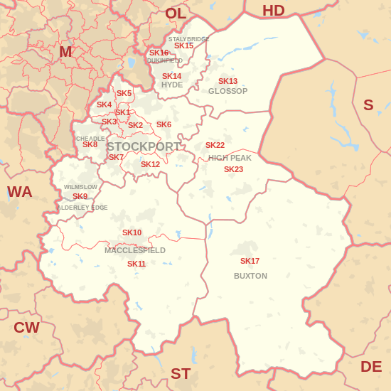
| Postcode district | Post town | Coverage | Local authority area |
|---|---|---|---|
| SK1 | STOCKPORT | Stockport | Stockport |
| SK2 | STOCKPORT | Stockport, Offerton | Stockport |
| SK3 | STOCKPORT | Stockport, Davenport, Edgeley, Adswood, Bridgehall | Stockport |
| SK4 | STOCKPORT | Stockport, Four Heatons, Reddish | Stockport |
| SK5 | STOCKPORT | Stockport, Brinnington, Reddish | Stockport |
| SK6 | STOCKPORT | Bredbury, Romiley, Woodley, Marple, Marple Bridge, High Lane | Stockport |
| SK7 | STOCKPORT | Bramhall, Hazel Grove, Woodford | Stockport |
| SK8 | CHEADLE | Cheadle, Cheadle Hulme, Gatley, Heald Green | Stockport |
| SK9 | WILMSLOW, ALDERLEY EDGE | Wilmslow, Alderley Edge, Handforth, Styal | Cheshire East |
| SK10 | MACCLESFIELD | Macclesfield (north), Bollington, Pott Shrigley, Prestbury, Rainow | Cheshire East |
| SK11 | MACCLESFIELD | Macclesfield (south), Sutton, Rushton Spencer | Cheshire East, Staffordshire Moorlands |
| SK12 | STOCKPORT | Disley, Poynton | Cheshire East |
| SK13 | GLOSSOP | Glossop, Hadfield | High Peak |
| SK14 | HYDE | Hyde, Broadbottom, Gee Cross, Hollingworth, Mottram in Longdendale | Tameside |
| SK15 | STALYBRIDGE | Stalybridge, Carrbrook, Heyrod, Matley, Millbrook | Tameside |
| SK16 | DUKINFIELD | Dukinfield | Tameside |
| SK17 | BUXTON | Buxton, Tideswell, Hartington, Longnor, Chelmorton | High Peak, Derbyshire Dales, Staffordshire Moorlands |
| SK22 | HIGH PEAK | Birch Vale, Hayfield, Little Hayfield, New Mills, Rowarth | High Peak |
| SK23 | HIGH PEAK | Buxworth, Chapel-en-le-Frith, Chinley, Combs, Furness Vale, Kettleshulme, Whaley Bridge | Cheshire East, High Peak |
The SK22 and SK23 districts and the HIGH PEAK post town were formed in 1996, out of the SK12 district and the STOCKPORT post town.[3]
Map
See also
References
- ↑ "ONS Postcode Directory Version Notes" (ZIP). National Statistics Postcode Products. Office for National Statistics. February 2012. Table 2. Retrieved 21 April 2012. Coordinates from mean of unit postcode points, "Code-Point Open". OS OpenData. Ordnance Survey. February 2012. Retrieved 21 April 2012.
- ↑ Royal Mail, Address Management Guide, (2004)
- ↑ Royal Mail, Postcode Update 23, July 1996
External links
This article is issued from
Wikipedia.
The text is licensed under Creative Commons - Attribution - Sharealike.
Additional terms may apply for the media files.