WC postcode area
Postcode district boundaries:
| London WC postcode area | |
|---|---|
 WC | |
| Postcode area | WC |
| Postcode area name | London WC |
| Post towns | 1 |
| Postcode districts | 15 |
| Postcode sectors | 46 |
| Postcodes (live) | 3,005 |
| Postcodes (total) | 7,279 |
| Statistics as at February 2012[1] | |
The WC (Western Central) postcode area, also known as the London WC postcode area,[2] is a group of postcode districts in central London, England. It includes minor parts of the London Borough of Camden, Islington, the City of Westminster, and a very small part of the City of London. It’s high density, including business premises, but its Bloomsbury component in the heart of WC1 has many garden squares, a set of open spaces which are mostly square. In the south, WC2, the largest open spaces are Leicester Square, a mixture of a city square and a green square, Covent Garden and in the barristers' district Lincoln's Inn Fields. Many of the major courts fall into this district.
Its postcode districts are late as WC1 and WC2 districts were established in 1917.[2] The simple north-south 1-2 relationship means other than for sorting of mail, the two numbered districts are occasionally used as a geographic reference and very commonly on street signs.
Postal administration
The WC1 and WC2 postcode districts are part of the London post town.[2] No dependent localities are used here.[2] Until the numbered districts were created in 1917, they formed a unified WC postal district. No significant recoding of the postcode area has taken place since 1990.[3][4]
Post Office branches in the WC1 postcode district are at Grays Inn, High Holborn, Marchmont Street and Russell Square; and in WC2 at Aldwych and Trafalgar Square.[5] The Western Central District Office on New Oxford Street, which was a stop on the London Post Office Railway. Deliveries for WC1 and WC2 now come from Mount Pleasant Mail Centre, in Farringdon Road.
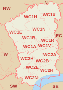
List of postcode districts
The postcode districts are, with approximate coverage:
| Postcode district | Post town | Coverage | Local authority area |
|---|---|---|---|
| WC1A | LONDON | New Oxford Street | Camden |
| WC1B | LONDON | Bloomsbury, British Museum, Southampton Row | Camden |
| WC1E | LONDON | University College London | Camden |
| WC1H | LONDON | St Pancras | Camden |
| WC1N | LONDON | Russell Square, Great Ormond Street | Camden |
| WC1R | LONDON | Gray's Inn | Camden |
| WC1V | LONDON | High Holborn | Camden, City of London |
| WC1X | LONDON | Kings Cross, Finsbury (west), Clerkenwell (north) | Camden, Islington |
| WC2A | LONDON | Lincoln's Inn Fields, Royal Courts of Justice, Chancery Lane | Camden, Westminster, City of London |
| WC2B | LONDON | Drury Lane, Kingsway, Aldwych | Camden, Westminster |
| WC2E | LONDON | Covent Garden | Westminster |
| WC2H | LONDON | Leicester Square, St. Giles | Camden, Westminster |
| WC2N | LONDON | Charing Cross | Westminster |
| WC2R | LONDON | Somerset House, Temple (west) | Westminster |
Boundaries
WC1
The WC1 postcode district (51°30′50″N 0°07′12″W / 51.514°N 0.120°W) is roughly bounded by Amwell Street, Rosebery Avenue and Gray's Inn Road to the east; New Oxford Street and High Holborn to the south (the boundary with WC2); Tottenham Court Road to the west; and Euston Road and Pentonville Road to the north, and approximately corresponds to the modern district of Bloomsbury, with parts of Holborn, King's Cross and St Pancras.[6] It includes Russell Square, Tavistock Square and Coram's Fields. It is mostly within the London Borough of Camden, although a small part towards the east is within the London Borough of Islington. It includes the British Museum and buildings owned by the federal University of London and its constituent colleges and institutes.
WC2
The WC2 postcode district (51°30′50″N 0°07′26″W / 51.514°N 0.124°W) is roughly bounded by Chancery Lane and Essex Street to the east, High Holborn and New Oxford Street to the north (the boundary with WC1), Wardour Street and Witcomb Street to the west and Northumberland Avenue and the River Thames to the south. It includes Leicester Square, Trafalgar Square and the Aldwych.[7] It corresponds roughly to the former district of Strand. It is mostly within the City of Westminster with the northern section in the London Borough of Camden and some small areas in the east in the City of London. It includes Somerset House, colleges of the University of London like King's College London (Strand campus), and the National Portrait Gallery.
Map
See also
References
- ↑ "ONS Postcode Directory Version Notes" (ZIP). National Statistics Postcode Products. Office for National Statistics. February 2012. Table 2. Retrieved 21 April 2012. Coordinates from mean of unit postcode points, "Code-Point Open". OS OpenData. Ordnance Survey. February 2012. Retrieved 21 April 2012.
- 1 2 3 4 Royal Mail (2004). Address Management Guide (4 ed.). Royal Mail Group.
- ↑ Royal Mail Address Management Unit (12 September 2006). "Royal Mail major recode historical information - 1990 to 1999" (DOC). Royal Mail Group. Retrieved 1 April 2010.
- ↑ Royal Mail Address Management Unit (18 April 2007). "Royal Mail major recode historical information – 2000 to March 2007" (PDF). Royal Mail Group. Retrieved 1 April 2010.
- ↑ Post Office -
- ↑ "WC1". The Postcodes Project. Museum of London. Archived from the original on 25 September 2012. Retrieved 23 March 2010.
- ↑ "WC2". The Postcodes Project. Museum of London. Archived from the original on 21 August 2006. Retrieved 23 March 2010.