PA postcode area
Postcode district boundaries:
| Paisley postcode area | |
|---|---|
 PA | |
| Postcode area | PA |
| Postcode area name | Paisley |
| Post towns | 35 |
| Postcode districts | 77 |
| Postcode sectors | 114 |
| Postcodes (live) | 9,192 |
| Postcodes (total) | 12,473 |
| Statistics as at February 2012[1] | |
The PA postcode area, also known as the Paisley postcode area,[2] is a group of postcode districts covering the post towns of Appin, Bishopton, Bridge of Orchy, Bridge of Weir, Cairndow, Campbeltown, Colintraive, Dalmally, Dunoon, Erskine, Gourock, Greenock, Inveraray, Isle of Bute, Isle of Coll, Isle of Colonsay, Isle of Gigha, Isle of Iona, Isle of Islay, Isle of Jura, Isle of Mull, Isle of Tiree, Johnstone, Kilmacolm, Lochgilphead, Lochwinnoch, Oban, Paisley, Port Glasgow, Renfrew, Skelmorlie, Tarbert, Taynuilt, Tighnabruaich and Wemyss Bay in Scotland.
Coverage
The approximate coverage of the postcode districts:
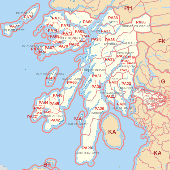
| Postcode district | Post town | Coverage | Local authority area |
|---|---|---|---|
| PA1 | PAISLEY | Paisley (central, east and north east), Ralston | Renfrewshire |
| PA2 | PAISLEY | Paisley (south), Castlehead | Renfrewshire |
| PA3 | PAISLEY | Paisley (north west), Linwood | Renfrewshire |
| PA4 | RENFREW | Renfrew, Inchinnan | Renfrewshire |
| PA5 | JOHNSTONE | Johnstone, Brookfield, Elderslie | Renfrewshire |
| PA6 | JOHNSTONE | Johnstone, Houston | Renfrewshire |
| PA7 | BISHOPTON | Bishopton | Renfrewshire |
| PA8 | ERSKINE | Erskine | Renfrewshire |
| PA9 | JOHNSTONE | Johnstone, Howwood | Renfrewshire |
| PA10 | JOHNSTONE | Johnstone | Renfrewshire |
| PA11 | BRIDGE OF WEIR | Bridge of Weir, Quarrier's Village | Renfrewshire |
| PA12 | LOCHWINNOCH | Lochwinnoch, Newton of Belltrees | Renfrewshire |
| PA13 | KILMACOLM | Kilmacolm | Inverclyde |
| PA14 | PORT GLASGOW | Port Glasgow, Langbank | Inverclyde |
| PA15 | GREENOCK | Greenock | Inverclyde |
| PA16 | GREENOCK | Greenock, Inverkip | Inverclyde |
| PA17 | SKELMORLIE | Skelmorlie | North Ayrshire |
| PA18 | WEMYSS BAY | Wemyss Bay | Inverclyde |
| PA19 | GOUROCK | Gourock | Inverclyde |
| PA20 | ISLE OF BUTE | Isle of Bute | Argyll and Bute |
| PA21 | TIGHNABRUAICH | Tighnabruaich | Argyll and Bute |
| PA22 | COLINTRAIVE | Colintraive, Glendaruel | Argyll and Bute |
| PA23 | DUNOON | Dunoon | Argyll and Bute |
| PA24 | CAIRNDOW | Lochgoilhead | Argyll and Bute |
| PA25 | CAIRNDOW | St. Catherines | Argyll and Bute |
| PA26 | CAIRNDOW | Cairndow | Argyll and Bute |
| PA27 | CAIRNDOW | Strachur | Argyll and Bute |
| PA28 | CAMPBELTOWN | Campbeltown | Argyll and Bute |
| PA29 | TARBERT | Tarbert | Argyll and Bute |
| PA30 | LOCHGILPHEAD | Ardrishaig | Argyll and Bute |
| PA31 | LOCHGILPHEAD | Lochgilphead, Cairnbaan, Crinan, Kilmartin | Argyll and Bute |
| PA32 | INVERARAY | Inveraray | Argyll and Bute |
| PA33 | DALMALLY | Dalmally | Argyll and Bute |
| PA34 | OBAN | Oban | Argyll and Bute |
| PA35 | TAYNUILT | Taynuilt | Argyll and Bute |
| PA36 | BRIDGE OF ORCHY | Bridge of Orchy | Argyll and Bute |
| PA37 | OBAN | Connel, Benderloch | Argyll and Bute |
| PA38 | APPIN | Appin | Argyll and Bute |
| PA41 | ISLE OF GIGHA | Gigha | Argyll and Bute |
| PA42 | ISLE OF ISLAY | Port Ellen | Argyll and Bute |
| PA43 | ISLE OF ISLAY | Bowmore | Argyll and Bute |
| PA44 | ISLE OF ISLAY | Bridgend | Argyll and Bute |
| PA45 | ISLE OF ISLAY | Ballygrant | Argyll and Bute |
| PA46 | ISLE OF ISLAY | Port Askaig | Argyll and Bute |
| PA47 | ISLE OF ISLAY | Portnahaven | Argyll and Bute |
| PA48 | ISLE OF ISLAY | Port Charlotte | Argyll and Bute |
| PA49 | ISLE OF ISLAY | Bruichladdich | Argyll and Bute |
| PA60 | ISLE OF JURA | Jura | Argyll and Bute |
| PA61 | ISLE OF COLONSAY | Colonsay | Argyll and Bute |
| PA62 | ISLE OF MULL | Lochbuie | Argyll and Bute |
| PA63 | ISLE OF MULL | Croggan | Argyll and Bute |
| PA64 | ISLE OF MULL | Lochdon | Argyll and Bute |
| PA65 | ISLE OF MULL | Craignure | Argyll and Bute |
| PA66 | ISLE OF MULL | Fionnphort | Argyll and Bute |
| PA67 | ISLE OF MULL | Bunessan | Argyll and Bute |
| PA68 | ISLE OF MULL | Gribun | Argyll and Bute |
| PA69 | ISLE OF MULL | Tiroran | Argyll and Bute |
| PA70 | ISLE OF MULL | Pennyghael | Argyll and Bute |
| PA71 | ISLE OF MULL | Gruline | Argyll and Bute |
| PA72 | ISLE OF MULL | Aros, Salen | Argyll and Bute |
| PA73 | ISLE OF MULL | Ulva Ferry | Argyll and Bute |
| PA74 | ISLE OF MULL | Torloisk | Argyll and Bute |
| PA75 | ISLE OF MULL | Tobermory, Calgary | Argyll and Bute |
| PA76 | ISLE OF IONA | Iona | Argyll and Bute |
| PA77 | ISLE OF TIREE | Tiree | Argyll and Bute |
| PA78 | ISLE OF COLL | Coll | Argyll and Bute |
| PA80 | OBAN | Morvern | Argyll and Bute |
Ballachulish and Kinlochleven were originally coded PA39 and PA40 respectively, before being transferred to the PH area in 1999 as PH49 and PH50.[3] The PA80 district was formed out of the PA34 district in 2011 following a campaign by residents of Morvern.[4][5]
Map

See also
References
- ↑ "ONS Postcode Directory Version Notes" (ZIP). National Statistics Postcode Products. Office for National Statistics. February 2012. Table 2. Retrieved 21 April 2012. Coordinates from mean of unit postcode points, "Code-Point Open". OS OpenData. Ordnance Survey. February 2012. Retrieved 21 April 2012.
- ↑ Royal Mail, Address Management Guide, (2004)
- ↑ "Royal Mail Postcode Update 30". Beacon Dodsworth. Retrieved 22 April 2017.
- ↑ "Morvern secures its own postcode from Royal Mail". BBC News. 22 December 2009. Retrieved 22 December 2009.
- ↑ "Royal Mail Postcode Update 52". Beacon Dodsworth. Retrieved 22 April 2017.