FY postcode area
Postcode district boundaries:
| Blackpool postcode area | |
|---|---|
 FY | |
| Postcode area | FY |
| Postcode area name | Blackpool |
| Post towns | 5 |
| Postcode districts | 9 |
| Postcode sectors | 42 |
| Postcodes (live) | 7,241 |
| Postcodes (total) | 9,647 |
| Statistics as at February 2012[1] | |
The FY postcode area, also known as the Blackpool postcode area,[2] is a group of postcode districts around Blackpool, Thornton-Cleveleys, Lytham St Annes, Poulton-le-Fylde and Fleetwood in England. The letters "FY" refer to the Fylde, which includes the whole postcode area.
Coverage
The approximate coverage of the postcode districts:
| Postcode district | Post town | Coverage | Local authority area |
|---|---|---|---|
| FY0 | BLACKPOOL | Non-geographic postcode | Blackpool |
| FY1 | BLACKPOOL | Blackpool Town Centre, North Shore, South Shore | Blackpool |
| FY2 | BLACKPOOL | Bispham | Blackpool |
| FY3 | BLACKPOOL | Grange Park, Layton, Marton, Staining, Stanley Park | Blackpool, Fylde, Wyre |
| FY4 | BLACKPOOL | Marton, South Shore, Squires Gate, Starr Gate | Blackpool, Fylde |
| FY5 | THORNTON-CLEVELEYS | Anchorsholme, Little Bispham, Thornton-Cleveleys | Blackpool, Wyre |
| FY6 | POULTON-LE-FYLDE | Carleton, Poulton-le-Fylde, Hambleton, Knott End-on-Sea, Preesall, Singleton, Stalmine | Wyre, Fylde |
| FY7 | FLEETWOOD | Fleetwood, Rossall | Wyre |
| FY8 | LYTHAM ST. ANNES | Lytham St. Annes, Moss Side | Fylde |
Some regions of the FY5 postcode area such as Little Bispham and Anchorsholme are generally considered to be suburbs of Blackpool due to being in that town's unitary authority area, despite having the Thornton-Cleveleys post town.
Map
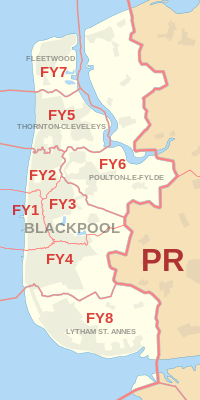
FY postcode area map, showing postcode districts in red and post towns in grey text, with link to nearby PR postcode area.
See also
References
- ↑ "ONS Postcode Directory Version Notes" (ZIP). National Statistics Postcode Products. Office for National Statistics. February 2012. Table 2. Retrieved 21 April 2012. Coordinates from mean of unit postcode points, "Code-Point Open". OS OpenData. Ordnance Survey. February 2012. Retrieved 21 April 2012.
- ↑ Royal Mail, Address Management Guide, (2004)
External links
This article is issued from
Wikipedia.
The text is licensed under Creative Commons - Attribution - Sharealike.
Additional terms may apply for the media files.