AB postcode area
Postcode district boundaries:
| Aberdeen postcode area | |
|---|---|
 AB | |
| Postcode area | AB |
| Postcode area name | Aberdeen |
| Post towns | 24 |
| Postcode districts | 40 |
| Postcode sectors | 176 |
| Postcodes (live) | 16,576 |
| Postcodes (total) | 37,813 |
| Statistics as at February 2012[1] | |
The AB postcode area, also known as the Aberdeen postcode area,[2] is a group of postcode districts around Aberdeen, Aberlour, Aboyne, Alford, Ballater, Ballindalloch, Banchory, Banff, Buckie, Ellon, Fraserburgh, Huntly, Insch, Inverurie, Keith, Laurencekirk, Macduff, Milltimber, Peterculter, Peterhead, Portlethen, Stonehaven, Strathdon, Turriff and Westhill in Scotland.
Coverage
The approximate coverage of the postcode districts:
| Postcode district | Post town | Coverage | Local authority area |
|---|---|---|---|
| AB10 | ABERDEEN | Bridge of Dee, Mannofield, Ruthrieston | Aberdeen |
| AB11 | ABERDEEN | Ferryhill, Torry | Aberdeen |
| AB12 | ABERDEEN | Altens, Ardoe, Banchory Devenick, Blairs, Bridge of Dee, Cove Bay, Kincorth, Maryculter, Nigg, Portlethen, Tullos | Aberdeen |
| AB13 | MILLTIMBER | Milltimber | Aberdeen |
| AB14 | PETERCULTER | Peterculter, Upper Anguston | Aberdeen |
| AB15 | ABERDEEN | Bieldside, Craigiebuckler, Cults, Hazlehead, Kingswells, Mannofield, Milltimber, Summerhill | Aberdeen |
| AB16 | ABERDEEN | Mastrick, Northfield, Middlefield, Cornhill, Sheddocksley | Aberdeen |
| AB21 | ABERDEEN | Blackburn, Bucksburn, Dyce, Fintray, Kinellar, Newmachar, Whiterashes | Aberdeen |
| AB22 | ABERDEEN | Bridge of Don, Danestone, Grandholm, Persley | Aberdeen |
| AB23 | ABERDEEN | Balmedie, Belhelvie, Bridge of Don, Potterton, Whitecairns | Aberdeen |
| AB24 | ABERDEEN | Old Aberdeen, Woodside, Tillydrone, Seaton, Bedford | Aberdeen |
| AB25 | ABERDEEN | Kittybrewster, Foresterhill, Rosemount, George Street | Aberdeen |
| AB30 | LAURENCEKIRK | Fettercairn, Marykirk, North Water Bridge, Luthermuir, Phesbo, Glensaugh, Auchenblae, Fordoun, Scotston, Arbuthnott | Aberdeenshire |
| AB31 | BANCHORY | Lumphanan, Torphins, Crathes | Aberdeenshire |
| AB32 | WESTHILL | Kirkton of Skene, Echt | Aberdeenshire |
| AB33 | ALFORD | Muir of Fowlis, Towie | Aberdeenshire |
| AB34 | ABOYNE | Kincardine O'Neil, Dinnet | Aberdeenshire |
| AB35 | BALLATER | Crathie, Braemar, Spittal of Glenmuick | Aberdeenshire |
| AB36 | STRATHDON | Corgarff | Aberdeenshire |
| AB37 | BALLINDALLOCH | Glenlivet, Tomintoul | Moray |
| AB38 | ABERLOUR | Craigellachie, Rothes | Moray |
| AB39 | STONEHAVEN | Stonehaven, Newtonhill | Aberdeenshire |
| AB41 | ELLON | Ellon, Tarves, Pitmedden, Udny | Aberdeenshire |
| AB42 | PETERHEAD | Hatton, St. Fergus | Aberdeenshire |
| AB43 | FRASERBURGH | Crimond | Aberdeenshire |
| AB44 | MACDUFF | Aberdeenshire | |
| AB45 | BANFF | Gardenstown, Gordonstown, Portsoy, Whitehills | Aberdeenshire |
| AB51 | INVERURIE | Inverurie, Kemnay, Kintore, Oldmeldrum | Aberdeenshire |
| AB52 | INSCH | Culsalmond, Largie, Auchleven, Oyne, Old Rayne, Colpy, Leslie, Wrangham, Duncanstone, Mill of Boddam | Aberdeenshire |
| AB53 | TURRIFF | Fyvie, New Deer | Aberdeenshire |
| AB54 | HUNTLY | Aberchirder, Cabrach, Cairnie, Forgue, Gartly, Glass, Kennethmont, Lumsden, Rhynie, Rothiemay | Aberdeenshire, Moray |
| AB55 | KEITH | Dufftown | Moray |
| AB56 | BUCKIE | Cullen, Portknockie, Findochty, Portessie, Portgordon | Moray |
| AB99 | ABERDEEN | Non-geographic postcode | Aberdeen City |
Originally, only postcode district numbers AB1 to AB5 were used, but in August 1990 the area was recoded to allocate a separate district number to each Post Town. At the same time, the postcode districts IV33, IV34 and IV35 were recoded as part of AB38.
Map
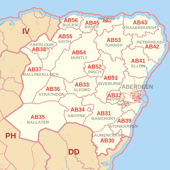

Detailed map of postcode districts and post towns in and around Aberdeen
See also
References
- ↑ "ONS Postcode Directory Version Notes" (ZIP). National Statistics Postcode Products. Office for National Statistics. February 2012. Table 2. Retrieved 21 April 2012. Coordinates from mean of unit postcode points, "Code-Point Open". OS OpenData. Ordnance Survey. February 2012. Retrieved 21 April 2012.
- ↑ Royal Mail, Address Management Guide, (2004)
External links
This article is issued from
Wikipedia.
The text is licensed under Creative Commons - Attribution - Sharealike.
Additional terms may apply for the media files.