Landess, Indiana
| Landess, Indiana | |
|---|---|
| Census-designated place | |
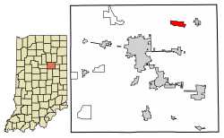 Location of Landess in Grant County, Indiana. | |
 Landess Location of Landess in Grant County, Indiana.  Landess Landess (the US) | |
| Coordinates: 40°36′39″N 85°33′39″W / 40.61083°N 85.56083°WCoordinates: 40°36′39″N 85°33′39″W / 40.61083°N 85.56083°W | |
| Country | United States |
| State | Indiana |
| County | Grant |
| Townships | Washington, Van Buren |
| Area | |
| • Total | 1.4 sq mi (3.6 km2) |
| • Land | 1.4 sq mi (3.6 km2) |
| • Water | 0.0 sq mi (0.0 km2) |
| Elevation | 866 ft (264 m) |
| Population (2010) | |
| • Total | 188 |
| • Density | 135/sq mi (52.1/km2) |
| ZIP code | 46991 |
| FIPS code | 18-41994[1] |
| GNIS feature ID | 437602[2] |
Landess is an unincorporated community and census-designated place (CDP) in Washington and Van Buren townships, Grant County, Indiana, in the United States.[2] As of the 2010 census it had a population of 188.[1]
History
Landess was founded in 1882 by William Landess.[3] A post office was established at Landess in 1884, and remained in operation until it was discontinued in 1996.[4]
Geography
Landess is located in northeastern Grant County, 9 miles (14 km) northeast of Marion, the county seat, and 3 miles (5 km) west of Van Buren. Interstate 69 forms the southeastern edge of the Landess CDP, but there is no access to the highway at this point. The closest interchanges are Exit 264 (Indiana State Road 18), 4 miles (6 km) to the south, and Exit 273 (State Road 5), 7 miles (11 km) to the northeast.
According to the U.S. Census Bureau, the Landess CDP has an area of 1.4 square miles (3.6 km2), all of it land.[1]
Demographics
| Historical population | |||
|---|---|---|---|
| Census | Pop. | %± | |
| U.S. Decennial Census[5] | |||
References
- 1 2 3 "Geographic Identifiers: 2010 Demographic Profile Data (G001): Landess CDP, Indiana". American Factfinder. U.S. Census Bureau. Retrieved December 5, 2016.
- 1 2 U.S. Geological Survey Geographic Names Information System: Landess, Indiana
- ↑ Baker, Ronald L. (October 1995). From Needmore to Prosperity: Hoosier Place Names in Folklore and History. Indiana University Press. p. 191. ISBN 978-0-253-32866-3.
...the town was laid out in 1882 by local storekeeper William Landess...
- ↑ "Grant County". Jim Forte Postal History. Retrieved 12 September 2014.
- ↑ "Census of Population and Housing". Census.gov. Retrieved June 4, 2016.
Municipalities and communities of Grant County, Indiana, United States | ||
|---|---|---|
| Cities | ||
| Towns | ||
| Townships | ||
| CDPs | ||
| Unincorporated communities | ||
| Footnotes | ‡This populated place also has portions in an adjacent county or counties | |