Anderson, South Carolina
| Anderson, South Carolina | |
|---|---|
| City | |
| City of Anderson | |
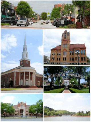 Top, left to right: Downtown Anderson, First Baptist Church of Anderson, Old Anderson County Courthouse, Anderson University, Anderson County Courthouse and Confederate Monument, Lake Hartwell view from City of Anderson Recreation Park | |
| Motto(s): "The Electric City" | |
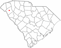 Location of Anderson, South Carolina | |
| Coordinates: 34°30′52″N 82°38′56″W / 34.51444°N 82.64889°WCoordinates: 34°30′52″N 82°38′56″W / 34.51444°N 82.64889°W | |
| Country | United States |
| State | South Carolina |
| County | Anderson |
| Government | |
| • Type | Council-manager government |
| • Mayor | Terence Roberts |
| • City Manager | Linda McConnell |
| Area | |
| • Total | 14.6 sq mi (37.9 km2) |
| • Land | 14.6 sq mi (37.8 km2) |
| • Water | 0.04 sq mi (0.1 km2) |
| Population | |
| • Total | 26,686 |
| • Density | 1,829/sq mi (706.0/km2) |
| Website |
www |
Anderson is a city in and the county seat of Anderson County, South Carolina, United States.[1] The population was 26,686 at the 2010 census,[2] and the city was the center of an urbanized area of 75,702.[3] It is one of the principal cities in the Greenville-Anderson--Mauldin Metropolitan Statistical Area, which had a population of 824,112 at the 2010 census. It is further included in the larger Greenville-Spartanburg-Anderson, South Carolina Combined Statistical Area, with a total population of 1,266,995, at the 2010 census. Anderson is just off Interstate 85 and is 120 miles (190 km) from Atlanta and 140 miles (230 km) from Charlotte.
Anderson is the smallest of the three primary cities that makes up the Upstate region and is nicknamed "The Electric City" and "The Friendliest City in South Carolina". Anderson's spirit and quality of life have earned national recognition as Anderson County was named an "All-America City" in 2000.
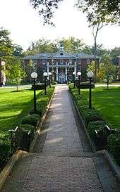
Anderson is the home of Anderson University, a selective private comprehensive university of approximately 3,400 undergraduate and graduate students.
History
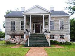
Anderson Court House

Cherokee first settled the area of what is today the city of Anderson. During the American Revolution the Cherokee sided with the British. After the American Revolutionary War the Cherokee surrendered their land. In 1791 the South Carolina legislature created the Washington District which comprised Greenville, Anderson, Oconee and Pickens counties. The Washington District was then divided into Greenville and Pendleton districts. Anderson, Pickens and Oconee comprised the newly created Pendleton district. Anderson was settled in 1826 and incorporated in 1828 as Anderson Court House separating from the Pendleton district. The name Anderson is in honor of Robert Anderson who fought in the American Revolutionary War and also explored the Anderson region in the mid-18th century. Anderson District (later Anderson County after 1867) was also established in 1826 out of the Pendleton district.
In 1851 the Johnson Female Seminary was established in Anderson as the first college of the town and was named after William Bullein Johnson. One year later the seminary was renamed Johnson University.[4] During the American Civil War Johnson University was closed and converted into a Confederate treasury. On May 1, 1865 Union forces invaded Anderson looking for the Confederate treasury. The treasury office of Anderson was ransacked by Union forces and the main building of Johnson University was used as a Union headquarters. A minor skirmish erupted at the Battle of Anderson leading to two Union casualties.[5] After the war a Union garrison was stationed in Anderson.
The Electric City
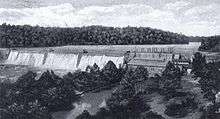
Anderson became one of the first cities in the Southeastern United States to have electricity. Electricity to Anderson was established by William C. Whitner in 1895 at a hydroelectric plant on the Rocky River giving the city the name "The Electric City." Anderson also became the first city in the world to supply a cotton gin by electricity. In 1895 Anderson Court House was renamed to Anderson.[6][7] In 1897 Whitner's plant was upgraded with a 10,000 volt generating station at Portman Shoals. Whitner's power plant at Portman Shoals became the first hydroelectric plant to generate high voltage without step-up transformers in the United States.[8] The Portman Dam was swept away in 1901 forcing Anderson to be in darkness until it was rebuilt in 1902.
In 1911 Anderson College was established by the Anderson Chamber of Commerce. Anderson College was a successor to the Johnson Female Seminary and is affiliated with the South Carolina Baptist Convention in particular the First Baptist Church of Anderson. Anderson College became a co-ed two year junior college in 1930 and in 2006 it became Anderson University.[9]
Geography
Anderson is located in the northwest corner of South Carolina on the Piedmont plateau. Anderson is a 1-hour drive from the Blue Ridge Mountains and a four-hour drive from the South Carolina coast. Anderson lies roughly at the midpoint of the busy I-85 corridor between Atlanta, Georgia, and Charlotte, North Carolina.
According to the United States Census Bureau, the city has a total area of 14.6 square miles (37.9 km2), of which 14.6 square miles (37.8 km2) is land and 0.039 square miles (0.1 km2), or 0.30%, is water.[10]
Cityscape
Historic districts
- Anderson College Historic District
- Anderson Downtown Historic District
- Anderson Historic District
- McDuffie Street Historic District
- South Boulevard Historic District
- Westside Historic District
- Whitner Street Historic District
- Other historical locations
- Caldwell-Johnson-Morris Cottage
- Denver Downs Farmstead
- Kennedy Street School
- North Anderson Historic District
- Dr. Samuel Marshall Orr House
- Ralph John Ramer House
Parks
- Anderson Memorial Stadium — A ballfield/stadium on 12 acres (4.9 ha) of land on White Road. Renovated in 2007 with stadium-style seating. Home to the Anderson University Trojans.
- Anderson Sports and Entertainment Center — A 300-acre (120 ha) area that includes the Anderson Civic Center, a 37,000 square feet (3,400 m2) facility, as well as one of South Carolina's largest amphitheaters that can accommodate 15,000 people, a huge castle-like play structure with play equipment, a 64-acre (26 ha) sports center with 7 baseball/softball fields, 3 soccer fields, disc golf course, and 8 tennis courts. There is also a lake with park, picnic shelters, and miles of nature trail. The ASCE is Anderson's largest recreational area.
Economy
Anderson's economy revolves around manufacturing. Anderson has over 230 manufacturers, including 22 international companies. In the county, Anderson has a thriving business climate. The top major industries in Anderson include manufacturers of automotive products, metal products, industrial machinery, plastics, publishing, and textiles. Two industries that many times interconnect are the plastic and automotive sectors. There are more than 27 BMW suppliers in the Upstate region, which is recognized internationally as an automotive supplier hub. The plastics industry has a strong presence in the Upstate, with 244 plastic companies located within the 10 counties of the state's northwest corner. Anderson County, in particular, has 11 automotive suppliers and is a major player in the plastic industry, with 27 plastics companies located within its borders. It has one unionized company in the area.
Hospitals
AnMed Health is one of the top employers in the county and the primary healthcare network for Anderson. AnMed Health Medical Center is the main medical facility, offering all the amenities of a standard hospital, as well as a heart and vascular center, and stroke/neurological center. Located two and a half miles north of the facility is the AnMed Health Campus which includes a women's and children's hospital, minor care, cancer center, speech and occupational therapy, and more. The AnMed Rehabilitation Hospital is located between the two facilities. AnMed has recently received national attention being awarded the "National Presidents Circle Award," and the "American College of Cardiology Foundation’s 2012 NCDR ACTION Registry–GWTG Platinum Performance Achievement Award."
In addition to these three network hospitals, AnMed also operates a number of smaller facilities throughout the city and county that range from a free clinic and minor care to doctor's offices.
Education
The city of Anderson is served by the Anderson County School System (specifically, Anderson School District Five). The school district has eleven elementary schools, five middle schools, and two high schools.
- Calhoun Academy of the Arts
- Centerville Elementary
- Concord Elementary
- Homeland Park Primary School
- McLees Academy of Leadership
- Midway Elementary School of Science and Engineering
- Nevitt Forest Community School of Innovation
- New Prospect STEM Academy
- North Pointe Elementary School
- Varennes Academy of Communications and Technology
- Whitehall Elementary, A Global Communication School
- McCants Middle School
- Southwood Academy of the Arts
- Robert Anderson Middle School
- Glenview Middle School
- Westside High School
- T. L. Hanna High School
- Anderson Five Career Campus
- Anderson Christian School
- Boulevard Child Enrichment Center
- Day Star School
- First Presbyterian Church Day School
- Grace Kindergarten
- Montessori School of Anderson
- Oakwood Christian School
- New Covenant School
- St Joseph Catholic School
- Temple Christian Academy
- West Anderson Christian Academy
Higher education
Transportation
Airport
Anderson is served by Anderson County Regional Airport (IATA: AND, ICAO: KAND). The airport is 3 miles (4.8 km) away from Anderson and has 2 runways; runway 5/23 is 6,000 feet (1,800 m) and runway 17/35 is 5,000 feet (1,500 m). The airport also has helipads. The airport has no control tower but is able to accommodate regional jet aircraft. In addition, the airport has a small terminal.
Roads and highways
Anderson has five signed exits on I-85, currently the city's only freeway. Several notable highways pass through the city, including U.S. Route 76 and U.S. Route 178 co-signed along Clemson Boulevard, also known as SC-Bus 28, and U.S. Route 29 leading to Hartwell, Georgia, to the south and Greenville to the north.
In 2011, construction began on a new east-west connector which is approximately three miles long between Clemson Boulevard and South Carolina Highway 81.[11] On August 16, 2010, the connector was voted to have four lanes with turn and bike lanes with a completion date set in October 2012.[12]
On November, 8th, 2013, the East-West Parkway formally opened to traffic.
Public transit
Anderson has four bus routes (Blue, Green, Red, and Gold) that travel to most major areas of the city, running every hour.[13] and also receives service from Clemson Area Transit (CATS) via the 4U route.[14] The city uses both newer hybrid buses and older style trolleys resembling Anderson's old streetcars. Inter-city bus travel is available through Greyhound Lines, located on West Whitner Street near downtown.
Though the city still doesn't have as extensive a transit system as more modern cities, it is making plans to expand its ventures. The city is currently trying to acquire a full-time office space for a downtown bus transfer center. There is also the potential for growth in the future, including a new line connecting Belton to Anderson.
Shopping
Anderson is one of the main shopping destinations in The Upstate. Locally owned stores such as Grady's Great Outdoors and Blake & Brady as well as big box stores occupy Anderson, mainly on Clemson Boulevard. Midtowne Park is a shopping center which opened in 2008 that features Kohl's, Dick's Sporting Goods, Staples, AT&T, Hardee's, and Ulta.
The Anderson Jockey Lot is also a well known shopping area located on US 29 about 7.5 miles from the heart of the city. The Jockey Lot is a flea market operating on 65 acres with enough spots inside and out for over 1,500 vendors. It operates on 65 acres of land and is open Friday, Saturday, and Sunday.
Anderson Mall
Anderson Mall is Anderson's largest shopping center. It opened in 1972 and has undergone many expansions. It currently has more than 76 specialty stores thanks to a renovation completed in 2008. The mall is owned by WP Glimcher and anchored by Sears, Belk, Dillards, and JC Penney. Dillards recently opened at the mall in the Fall of 2008 as part of the renovation project. The front of the mall was also remodeled with Books-A-Million relocating to this area, along with several other stores.
Demographics
| Historical population | |||
|---|---|---|---|
| Census | Pop. | %± | |
| 1860 | 625 | — | |
| 1870 | 1,432 | 129.1% | |
| 1880 | 1,850 | 29.2% | |
| 1890 | 3,018 | 63.1% | |
| 1900 | 5,498 | 82.2% | |
| 1910 | 9,654 | 75.6% | |
| 1920 | 10,570 | 9.5% | |
| 1930 | 14,383 | 36.1% | |
| 1940 | 19,424 | 35.0% | |
| 1950 | 19,770 | 1.8% | |
| 1960 | 41,316 | 109.0% | |
| 1970 | 27,556 | −33.3% | |
| 1980 | 27,546 | 0.0% | |
| 1990 | 26,184 | −4.9% | |
| 2000 | 25,514 | −2.6% | |
| 2010 | 26,686 | 4.6% | |
| Est. 2016 | 27,544 | [15] | 3.2% |
| U.S. Decennial Census | |||
At the census[16] of 2000, there were 25,514 people, 10,641 households, and 6,299 families residing in the city. The population density was 1,843.7 people per square mile (711.8/km²). There were 12,068 housing units at an average density of 872.1 per square mile (336.7/km²). The racial makeup of the city was 63.12% White, 34.01% African American, 0.22% Native American, 0.78% Asian American, 0.04% Pacific Islander, 0.68% from other races, and 1.16% from two or more races. Hispanic or Latino of any race were 1.48% of the population.
There were 10,641 households out of which 25.4% had children under the age of 18 living with them, 36.9% were married couples living together, 18.7% had a female householder with no husband present, and 40.8% were non-families. 36.0% of all households were made up of individuals and 16.3% had someone living alone who was 65 years of age or older. The average household size was 2.22 and the average family size was 2.89.
In the city, the population was spread out with 22.2% under the age of 18, 10.7% from 18 to 24, 26.3% from 25 to 44, 20.4% from 45 to 64, and 20.4% who were 65 years of age or older. The median age was 38 years. For every 100 females, there were 82.3 males. For every 100 females age 18 and over there were 77.5 males.
Anderson is the central city of an urbanized area with a total population of 70,530 (2000 census). This urban area is within the larger Greenville-Spartanburg metropolitan statistical area.
Government
Anderson is governed using the mayor-council system. The Mayor is elected at-large. The city council consists of eight members. Six are elected from districts and the other two are elected at large.
Notable people
- James Lee Barrett, theater producer and writer
- Chadwick Boseman, actor (Black Panther, 42, Get on Up, Captain America: Civil War)
- Ben Boulware, professional football player
- Lou Brissie, Major League Baseball player with Philadelphia Athletics and Cleveland Indians from 1947 to 1953
- Milford Burriss, state legislator
- Guy Davenport, novelist, poet, and scholar
- Shaun Ellis, professional football player
- Bailey Hanks, winner of MTV's Legally Blonde the Musical: The Next Elle Woods
- Preston Jones, professional football player[17]
- James Robert "Radio" Kennedy, subject of motion picture Radio; there is now a statue of him in town
- Rafael Little, professional football player, Canadian Football League
- Johnny Mann, arranger, composer, conductor, entertainer, and recording artist; Honorary Alumnus (D. Hum.) from Anderson University
- Adam Minarovich, film director and actor, Anderson University alumnus (The Walking Dead)[18]
- Charles Murphey (1799–1861), United States congressman from Georgia[19]
- Larry Nance, retired NBA basketball player with Phoenix Suns and Cleveland Cavaliers, 3-time All-Star
- James Lawrence Orr, former Governor of South Carolina and Speaker of the United States House of Representatives
- Lu Parker, Miss South Carolina USA 1994, Miss USA 1994, television personality and journalist
- Wesley Quinn, dancer/singer in popular boy band V Factory
- Jim Rice, professional baseball player with Boston Red Sox from 1974 to 1989, member of National Baseball Hall of Fame, Class of 2009
- Jessica Stroup, actress on television series 90210 and The Following
- Ben Taylor, Negro League professional baseball player from 1908 to 1929, manager/coach from 1929 to 1940, member of National Baseball Hall of Fame, Class of 2006
- James Michael Tyler, actor who portrayed Gunther on NBC sitcom Friends, alumnus of Anderson University
- George Webster, former AFL and NFL football player, two-time All American at Michigan State University, 1965–66
Elliot Crayton McCants, published author of several books, known for writings about the Reconstruction era following the Civil War, also was Superintendent of Anderson schools for many years.
Sister cities
Anderson has 2 sister cities, as designated by Sister Cities International.:[20]


References
- ↑ "Find a County". National Association of Counties. Archived from the original on 2011-05-31. Retrieved 2011-06-07.
- ↑ "Anderson (city) QuickFacts". Quickfacts.census.gov. Retrieved 2014-06-26.
- ↑ "Geographic Identifiers: 2010 Census Summary File 1 (G001): Anderson, SC Urbanized Area (2010)". U.S. Census Bureau, American Factfinder. Retrieved August 7, 2013.
- ↑ "Johnson Female Seminary". The Abbeville Banner. January 29, 1851.
- ↑ "Area schools affected by Civil War". Independent Mail. July 5, 2014. Retrieved 20 November 2016.
- ↑ "History of Anderson, South Carolina". u-s-history.com.
- ↑ "Anderson: "The Electric City"". Retrieved 9 February 2016.
- ↑ "The South Carolina man who put the electric in "The Electric City"". Appalachianhistory.net. Retrieved 20 November 2016.
- ↑ "Anderson University - Anderson, South Carolina". Sciway.net. Retrieved 20 November 2016.
- ↑ "Geographic Identifiers: 2010 Demographic Profile Data (G001): Anderson city, South Carolina". U.S. Census Bureau, American Factfinder. Retrieved August 7, 2013.
- ↑ "News – City of Anderson, SC". Cityofandersonsc.com. Archived from the original on 2014-06-27. Retrieved 2014-06-26.
- ↑ Foster, Kisha (2010-08-17). "4-Lanes Approved For East-West Connector | WYFF Home - WYFF Home". Wyff4.com. Archived from the original on 2012-03-23. Retrieved 2014-06-26.
- ↑
- ↑ "Clemson Area Transit - Anderson Route". Catbus.com. Archived from the original on 2014-06-27. Retrieved 2014-06-26.
- ↑ "Population and Housing Unit Estimates". Retrieved June 9, 2017.
- ↑ "American FactFinder". United States Census Bureau. Archived from the original on 2013-09-11. Retrieved 2008-01-31.
- ↑ "Former Hanna QB Preston Jones returns to alma mater as receivers coach". independentmail.com. July 19, 2012. Archived from the original on December 19, 2014. Retrieved November 17, 2014.
- ↑ Wake, Matt (2010-10-19). "Following the "Dead," Local lands recurring role in AMC's new zombie series". Metromix Greenville. Archived from the original on 2 November 2010. Retrieved 2010-11-27.
- ↑ Who Was Who in America, Historical Volume, 1607-1896. Chicago: Marquis Who's Who. 1963.
- ↑ http://www.sister-cities.org/interactive-map/Anderson,%20South%20Carolina
External links
| Wikivoyage has a travel guide for Anderson (South Carolina). |
Municipalities and communities of Anderson County, South Carolina, United States | ||
|---|---|---|
| Cities | 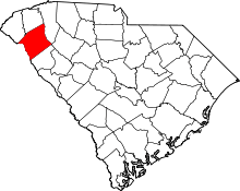 | |
| Towns | ||
| CDPs | ||
| Unincorporated communities | ||
| Footnotes | ‡This populated place also has portions in an adjacent county or counties | |