Isle of Palms, South Carolina
| Isle of Palms, South Carolina | |
|---|---|
| City | |
 | |
 Location of Isle of Palms in South Carolina | |
| Coordinates: 32°47′24″N 79°47′2″W / 32.79000°N 79.78389°WCoordinates: 32°47′24″N 79°47′2″W / 32.79000°N 79.78389°W | |
| Country | United States |
| State | South Carolina |
| County | Charleston |
| Incorporated | 1938 (town), 1957 (city) |
| Government | |
| • Mayor | Jimmy Carrol |
| Area | |
| • Total | 5.4 sq mi (14.1 km2) |
| • Land | 4.4 sq mi (11.5 km2) |
| • Water | 1.0 sq mi (2.6 km2) |
| Elevation | 11 ft (3 m) |
| Population (2010) | |
| • Total | 4,133 |
| • Density | 932/sq mi (359.7/km2) |
| Time zone | UTC−5 (EST) |
| • Summer (DST) | UTC−4 (EDT) |
| ZIP code | 29451 |
| Area code | 843 |
| FIPS code | 45-36115[1] |
| GNIS feature ID | 1227790[2] |
| Website |
www |
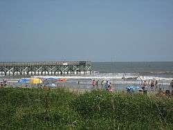
Isle of Palms is a city in Charleston County, South Carolina, United States. At the 2010 census, the population was 4,133.[3] Isle of Palms is a barrier island on the South Carolina coast. The city is included within the Charleston-North Charleston-Summerville metropolitan area and the Charleston-North Charleston Urbanized Area. The town lies along a narrow strip of land, hugging the beach, separated from the mainland by the Intracoastal Waterway. It is an affluent community of both vacation home owners and year-round residents, with large beachfront homes, resorts, and local restaurants. Beach volleyball is popular in the summer, and the "Windjammer" club hosts several tournaments throughout the year.
Geography
Isle of Palms is located along the Atlantic Ocean, 15 miles (24 km) by road east of downtown Charleston. According to the United States Census Bureau, the city of Isle of Palms has a total area of 5.4 square miles (14.1 km2), of which 4.4 square miles (11.5 km2) is land, and 1.0 square mile (2.6 km2) (18.40%) is water.[3]
Airport
The city of Isle of Palms is served by the Charleston International Airport. It is located in the City of North Charleston and is about 12 mi (19 km) northwest of Isle of Palms. It is the busiest passenger airport in South Carolina (IATA: CHS, ICAO: KCHS). The airport shares runways with the adjacent Charleston Air Force Base. Charleston Executive Airport is a smaller airport located in the John's Island section of the city of Charleston and is used by noncommercial aircraft. Both airports are owned and operated by the Charleston County Aviation Authority.
Demographics
| Historical population | |||
|---|---|---|---|
| Census | Pop. | %± | |
| 1960 | 1,186 | — | |
| 1970 | 2,657 | 124.0% | |
| 1980 | 3,421 | 28.8% | |
| 1990 | 3,680 | 7.6% | |
| 2000 | 4,583 | 24.5% | |
| 2010 | 4,133 | −9.8% | |
| Est. 2016 | 4,395 | [4] | 6.3% |
| U.S. Decennial Census[5] | |||

As of the census[1] of 2010, there were 4,133 people residing in the city. The population density was 743.6 people per square mile (287.1/km²). There were 4,274 housing units at an average density of 868.7 per square mile (296.8/km²). The racial makeup of the city was 97.65% White, 1.06% Hispanic or Latino, 0.56% African American, 0.75% Asian, 0.15% Native American, 0.17% from other races, and 0.73% from two or more races.
There were 1,828 households, of which 20.1% had children under the age of 18 living with them, 62.4% were married couples living together, 6.4% had a female householder with no husband present, and 28.8% were non-families. 20.9% of all households were made up of individuals and 7.5% had someone living alone who was 65 years of age or older. The average household size was 2.26 and the average family size was 2.66.
The city population was spread out with 17.0% under the age of 18, 3.2% from 18 to 24, 23.8% from 25 to 49, 31.8% from 50 to 64, and 22.6% who were 65 years of age or older. The median age was 47. For every 100 females, there were 98 males.
The median income for a household in the city was $76,170, and the median income for a family was $88,874. Males had a median income of $60,640 versus $37,500 for females. The per capita income for the city was $44,221. About 1.7% of families and 3.4% of the population were below the poverty line, including 4.3% of those under age 18 and 1.0% of those age 65 or over.
Government
The city is run by an elected Mayor-council government system.
Mayor
Jimmy Carroll
Council members
Randy Bell, Ryan L. Buckhannon, Jimmy Carroll (Mayor), Ted Kinghorn, John Moye, Carol Rice, Susan Hill Smith, Jimmy Ward.[6]
History
The island's original inhabitants were the Sewee tribe.
During the Civil War, the H.L. Hunley departed from Breach Inlet, between Isle of Palms and Sullivan's Island.
In the late nineteenth century, local residents began using the island as a vacation spot. At that time it was only accessible by ferry. It was bought by J.S. Lawrence in 1899, who gave the island its current name; before then it was known as "Hunting Island" or "Long Island". A 50-room hotel was built in 1906. In 1912, James Sottile had a beach pavilion and an amusement park built, and a trolley line was constructed from Mount Pleasant on the mainland to Isle of Palms via Sullivan's Island. In 1929, Grace Memorial Bridge was built between Charleston and Mount Pleasant to allow automobile traffic to reach the island.
Large-scale residential development began when J.C. Long bought up most of the island and built low-cost housing for World War II veterans. In 1975, the Sea Pines Company (of Hilton Head Island fame) established the 900-acre (360 ha) development now known as the Wild Dunes Beach and Racquet Club.
E. Lee Spence, a pioneer underwater archaeologist and prolific author of books and articles about shipwrecks and sunken treasure, discovered, with the help of Isle of Palms residents Wally Shaffer and George Campsen, many shipwrecks along the shores of the Isle of Palms in the 1960s. Their discoveries included the Civil War blockade runners Rattlesnake, Stonewall Jackson, Mary Bowers, Constance, Norseman and the Georgiana. The iron-hulled steamer Georgiana, which was sunk on her maiden voyage, was described in contemporary documents as pierced for 14 guns and more powerful than the famous Confederate cruiser Alabama. These historic discoveries resulted in the passage of South Carolina's Underwater Antiquities Act allowing the archaeological salvage of shipwrecks.
During Hurricane Hugo, which struck September 21, 1989, much of the island was flooded by the storm surge.
The northeastern end of the Isle of Palms, which is home to the private community of Wild Dunes, endured a severe erosion crisis as a shoal attached to that section of the island and caused sand to be washed away from around the foundation of a large condominium. The city undertook a controversial beach restoration project in the spring and summer of 2008[7] which replenished the beach with dredged sand and saved the threatened structures.
County parks
The Charleston County Park and Recreation Commission (CCPRC)[8] operates numerous facilities within Charleston County including Isle of Palms County Park.
Marinas and boat landings:
- Cooper River Marina
- Multiple county-wide boat landings
See also
References
- 1 2 "American FactFinder". United States Census Bureau. Retrieved 2008-01-31.
- ↑ "US Board on Geographic Names". United States Geological Survey. 2007-10-25. Retrieved 2008-01-31.
- 1 2 "Geographic Identifiers: 2010 Census Summary File 1 (G001): Isle of Palms city, South Carolina". U.S. Census Bureau, American Factfinder. Retrieved June 25, 2015.
- ↑ "Population and Housing Unit Estimates". Retrieved June 9, 2017.
- ↑ "Census of Population and Housing". Census.gov. Archived from the original on May 12, 2015. Retrieved June 4, 2015.
- ↑ "Archived copy". Archived from the original on 2015-04-02. Retrieved 2014-06-08. www.iop.net
- ↑ "Isle of Palms". iop.net. Archived from the original on 2008-07-08.
- ↑ "Charleston County Parks and Recreation - Official Website". ccprc.com.
External links
| Wikimedia Commons has media related to Isle of Palms, South Carolina. |

- Official website of Isle of Palms
- Island Eye News, bi-weekly newspaper of Isle of Palms and Sullivan's Island
- Isle of Palms at Curlie (based on DMOZ)
Municipalities and communities of Charleston County, South Carolina, United States | ||
|---|---|---|
| Cities | 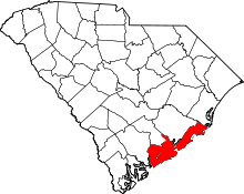 | |
| Towns | ||
| CDP | ||
| Unincorporated communities | ||
| Footnotes | ‡This populated place also has portions in an adjacent county or counties | |