Horry County, South Carolina
| Horry County, South Carolina | |
|---|---|
| County | |
| County of Horry | |
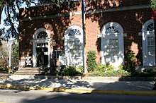
.jpg) Horry County Government and Justice Center | |
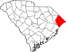 Location in the U.S. state of South Carolina | |
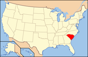 South Carolina's location in the U.S. | |
| Founded | 1801 |
| Named for | Peter Horry |
| Seat | Conway |
| Largest city | Myrtle Beach |
| Area | |
| • Total | 1,255 sq mi (3,250 km2) |
| • Land | 1,134 sq mi (2,937 km2) |
| • Water | 121 sq mi (313 km2), 9.6% |
| Population (est.) | |
| • (2017) | 333,268 |
| • Density | 237/sq mi (92/km2) |
| ZIP Code(s) | 29511, 29526, 29527, 29527, 29528, 29544, 29545,29566, 29567, 29568, 29569, 29572, 29575, 29576. 29577, 29578, 29579, 29581, 29582, 29585, 29587, 29588, 29597, 29598 [1] |
| Area code(s) | 843 |
| Congressional district | 7th |
| Time zone | Eastern: UTC−5/−4 |
| Website |
www |
Horry County (/ˈɒriː/ ORR-ee) is a county in the U.S. state of South Carolina. As of the 2010 census, its population was 289,650,[2] making it the fifth-most populous county in South Carolina. The county seat is Conway.[3]
Horry County is the central county in the Myrtle Beach-Conway-North Myrtle Beach, SC-NC Metropolitan Statistical Area. It is in the Pee Dee region of South Carolina, approximately 90 miles north of Charleston, South Carolina and approximately 130 miles east of the state capital, Columbia.
History
Horry County (pronounced O'Ree) was created from Georgetown District in 1801. At that time the county had an estimated population of 550. Isolated by the many rivers and swamps typical of the South Carolina Low Country, the area was essentially surrounded by water, forcing its inhabitants to survive virtually without assistance from the "outside world". This caused the county residents to become an extremely independent populace, and they named their county "The Independent Republic of Horry". The county was named after, and in honor of, Revolutionary War hero, Peter Horry[4] who was born in South Carolina around 1743. Horry started his military career in 1775 as one of 20 captains, elected by the Provincial Congress of South Carolina, to serve the 1st and 2nd Regiments. In 1790 he was assigned to the South Carolina militia under Brigadier General Francis Marion [5]
The population has increased more than fourfold since 1970, as the area has become a destination for retirees and people owning second homes. It has been developed for resorts and retirement communities. The majority-white residents have constituted a majority-Republican voter base since the late 20th century.
On October 29, 2012, the county paid homage to the man for whom the county is named. It commissioned a bronze sculpture of Peter Horry, installing it inside the Horry County Government and Justice Center. The sculpture was designed by Lubbock, Texas artist Garland Weeks. Coastal Monument of Conway, South Carolina designed the stone base. The base of the sculpture is inscribed with the names of the 1801 commissioners on one side and the names of 2011 Horry County Council members on the other; a brief bio of General Peter Horry is on the front. It cost slightly more than $16,200 for both the bust/sculpture and the stone base.[6] [7]
Geography
According to the U.S. Census Bureau, the county has a total area of 1,255 square miles (3,250 km2), of which 1,134 square miles (2,940 km2) is land and 121 square miles (310 km2) (9.6%) is water.[8] It is the largest county by area in South Carolina. The highest point in the county is 124 ft. above sea level.[9]
Horry County is in the northeastern corner of South Carolina. It is a diverse land made up of rivers, beaches, forest and swamps. Horry County is bordered by the Atlantic Ocean to the east, the Little Pee Dee River and Drowning Creek (also known as the Lumber River) on Horry's western side, and North Carolina to the north. Waccamaw River, approximately 140 miles (225 kilometers) long, runs through southeastern North Carolina and eastern South Carolina into Horry County. The river runs through the coastal plain, along the eastern border between the two states, and into the Atlantic Ocean.[10]
Adjacent counties
- Columbus County, North Carolina - northeast
- Brunswick County, North Carolina - east
- Robeson County, North Carolina - northwest
- Georgetown County - southwest
- Marion County - west
- Dillon County - northwest
National protected area
Demographics
| Historical population | |||
|---|---|---|---|
| Census | Pop. | %± | |
| 1810 | 4,349 | — | |
| 1820 | 5,025 | 15.5% | |
| 1830 | 5,245 | 4.4% | |
| 1840 | 5,755 | 9.7% | |
| 1850 | 7,646 | 32.9% | |
| 1860 | 7,962 | 4.1% | |
| 1870 | 10,721 | 34.7% | |
| 1880 | 15,574 | 45.3% | |
| 1890 | 19,256 | 23.6% | |
| 1900 | 23,364 | 21.3% | |
| 1910 | 26,995 | 15.5% | |
| 1920 | 32,077 | 18.8% | |
| 1930 | 39,376 | 22.8% | |
| 1940 | 51,951 | 31.9% | |
| 1950 | 59,820 | 15.1% | |
| 1960 | 68,247 | 14.1% | |
| 1970 | 69,992 | 2.6% | |
| 1980 | 101,419 | 44.9% | |
| 1990 | 144,053 | 42.0% | |
| 2000 | 196,629 | 36.5% | |
| 2010 | 269,291 | 37.0% | |
| Est. 2017 | 333,268 | [11] | 23.8% |
| U.S. Decennial Census[12] 1790-1960[13] 1900-1990[14] 1990-2000[15] 2010-2015[2] | |||
As of the 2010 United States Census, there were 269,291 people, 112,225 households, and 72,254 families residing in the county.[16] The population density was 237.5 inhabitants per square mile (91.7/km2). There were 185,992 housing units at an average density of 164.0 per square mile (63.3/km2).[17] The racial makeup of the county was 79.9% white, 13.4% black or African American, 1.0% Asian, 0.5% American Indian, 0.1% Pacific islander, 3.1% from other races, and 2.0% from two or more races. Those of Hispanic or Latino origin made up 6.2% of the population.[16] In terms of ancestry, 15.3% were American, 13.4% were African American (which can include other ethnicities), 13.3% were Irish, 12.8% were German, 11.3% were English, and 6.1% were Italian.[18]
Of the 112,225 households, 27.3% had children under the age of 18 living with them, 47.2% were married couples living together, 12.5% had a female householder with no husband present, 35.6% were non-families, and 26.8% of all households were made up of individuals. The average household size was 2.37 and the average family size was 2.84. The median age was 41.1 years.[16]
The median income for a household in the county was $43,142 and the median income for a family was $51,608. Males had a median income of $37,351 versus $29,525 for females. The per capita income for the county was $24,811. About 11.6% of families and 16.1% of the population were below the poverty line, including 25.2% of those under age 18 and 7.5% of those age 65 or over.[19]
Law and government
County Council
Horry County has a county council whose members represent 11 single-member districts within the county, with a chairman voted at-large. The county council usually meets at 6 p.m on first and third Tuesday of every month in the Council Chambers at the Horry County Government and Justice Center at 1301 2nd Avenue in Conway.
County Council members
| Name | Political Affiliation | District | Term Expires |
|---|---|---|---|
| Mark Lazarus | Republican | Chairman | 12/31/2018 |
| Harold Worley | Republican | 1 | 12/31/2018 |
| Bill Howard | Republican | 2 | 12/31/2018 |
| Dennis DiSabato | Republican | 3 | 12/31/2020 |
| Gary Loftus | Republican | 4 | 12/31/2020 |
| Tyler Servant | Republican | 5 | 12/31/2018 |
| Cam Crawford | Republican | 6 | 12/31/2020 |
| Harold Philips | Democrat | 7 | 12/31/2018 |
| Johnny Vaught | Republican | 8 (Vice Chairman) | 12/31/2018 |
| W. Paul Prince | Republican | 9 | 12/31/2020 |
| Danny Hardee | Republican | 10 | 12/31/2020 |
| Al Allen | Republican | 11 | 12/31/2018 |
- Patricia S. Hartley - Clerk to Council
Law enforcement
The Horry County Police Department provides 24-hour services to the unincorporated areas of the county. It is the only county police department in the State of South Carolina.[20] The Horry County Sheriff's Office is responsible for numerous tasks, including courthouse security, processing of warrants, fingerprinting, registration of sex offenders, funeral escorts, background checks and managing the J. Reuben Long Detention Center.[21] The South Carolina Highway Patrol has a Troop 5 barracks in Conway, and they provide services throughout the county.[22] Myrtle Beach, Conway, Briarcliffe Acres, Atlantic Beach, Surfside Beach, Loris, and Aynor all have their own police departments which patrol within the relevant town or city's border. North Myrtle Beach has a Public Safety Department, which provides police and fire services in the city of North Myrtle Beach.[23]
Politics
| Year | Republican | Democratic | Third parties |
|---|---|---|---|
| 2016 | 67.2% 89,288 | 29.7% 39,410 | 3.2% 4,222 |
| 2012 | 64.2% 72,127 | 34.6% 38,885 | 1.2% 1,381 |
| 2008 | 61.7% 64,609 | 37.1% 38,879 | 1.3% 1,310 |
| 2004 | 62.0% 50,447 | 36.3% 29,547 | 1.7% 1,353 |
| 2000 | 56.6% 40,300 | 40.9% 29,113 | 2.6% 1,852 |
| 1996 | 47.9% 26,159 | 43.4% 23,722 | 8.7% 4,772 |
| 1992 | 45.9% 23,489 | 36.9% 18,896 | 17.2% 8,819 |
| 1988 | 64.7% 24,843 | 34.7% 13,316 | 0.7% 250 |
| 1984 | 69.2% 20,396 | 30.3% 8,940 | 0.4% 127 |
| 1980 | 49.6% 14,323 | 48.1% 13,888 | 2.3% 653 |
| 1976 | 37.2% 9,339 | 62.6% 15,720 | 0.2% 58 |
| 1972 | 76.8% 15,324 | 22.3% 4,437 | 0.9% 183 |
| 1968 | 27.0% 3,924 | 27.0% 3,924 | 46.1% 6,701 |
| 1964 | 60.4% 8,293 | 39.6% 5,444 | |
| 1960 | 38.6% 3,768 | 61.5% 6,006 | |
| 1956 | 13.4% 1,092 | 59.2% 4,835 | 27.5% 2,244 |
| 1952 | 45.3% 3,716 | 54.7% 4,489 | |
| 1948 | 2.9% 113 | 12.7% 503 | 84.5% 3,345 |
| 1944 | 5.0% 137 | 88.1% 2,403 | 6.9% 188 |
| 1940 | 7.2% 164 | 92.8% 2,111 | |
| 1936 | 0.0% 0 | 100.0% 2,927 | |
| 1932 | 0.9% 29 | 99.1% 3,224 | |
| 1928 | 2.2% 27 | 97.8% 1,224 | |
| 1924 | 0.1% 1 | 99.7% 1,346 | 0.2% 3 |
| 1920 | 2.8% 49 | 97.2% 1,709 | |
| 1916 | 0.0% 0 | 99.6% 1,638 | 0.4% 7 |
| 1912 | 1.5% 13 | 97.7% 863 | 0.8% 7 |
| 1904 | 3.9% 40 | 96.1% 980 | |
| 1900 | 5.6% 79 | 94.4% 1,330 |
Economy
In 2013, PTR Industries, a gunmaker,[25] relocated to the Cool Springs Business Park[26] near Aynor from Bristol, Connecticut. That state had passed restrictive gun control legislation following the Sandy Hook Elementary School shooting.
Twenty-one PTR employees relocated from Bristol. The company said that it would hire an additional 30 workers in the first quarter of 2014, with a goal of having 120 employees by 2017.[27]
Transportation
Airports
- Myrtle Beach International Airport (MYR)
- Grand Strand Airport - North Myrtle Beach (CRE)
- Conway-Horry County Airport (HYW)
- Twin City Airport - Loris (5J9)
- Green Sea Airport (S79)
Mass transit
- The Coast RTA[28] - Bus system operating seven days a week, 364 days a year. 15 routes throughout the Horry County/Grand Strand area, including Myrtle Beach, North Myrtle Beach, Surfside Beach, Garden City, Conway, Loris, and Aynor.
Major highways
Communities
Cities
- Conway (county seat)
- Loris
- Myrtle Beach (Largest City)
- North Myrtle Beach
Towns
Census-designated places
- Bucksport
- Forestbrook
- Garden City (partially in Georgetown County)
- Little River
- Red Hill
- Socastee
Unincorporated communities
- Adrian
- Allsbrook
- Baxter Forks
- Bayboro
- Brooksville
- Bucksville
- Buck Forest
- Burgess
- Carolina Forest
- Causey
- Cedar Branch
- Cherry Grove Beach
- Chestnut Hill
- Cool Spring
- Crescent Beach
- Daisy
- Dog Bluff
- Dongola
- Duford
- Fantasy Harbour
- Finklea
- Floyds Crossroads
- Galivants Ferry
- Glass Hill
- Goretown
- Green Sea
- Gurley
- Hand
- Hammond
- Hickory Grove
- Homewood
- Horry
- Howard
- Ingram Beach
- Jordanville
- Ketchuptown
- Klondike
- Konig
- Little Town
- Live Oak
- Longs
- Mt. Calvary
- Mt. Olive
- Nixonville
- Nixons Crossroads
- Ocean Drive Beach
- Pee Dee Crossroads
- Pine Island
- Playcards
- Polecat Landing
- Poplar
- Red Bluff
- Stephens Crossroads
- Shell
- Springmaid Beach
- Toddville
- Wampee
- Windy Hill Beach
- Worthams Ferry
See also
References
- ↑ "Zip Code List - 295 in South Carolina". Capital Impact Government Gateway. Retrieved 20 February 2018.
- 1 2 "State & County QuickFacts". United States Census Bureau. Archived from the original on July 11, 2011. Retrieved November 22, 2013.
- ↑ "Find a County". National Association of Counties. Archived from the original on 2011-05-31. Retrieved 2011-06-07.
- ↑ Gannett, Henry (1905). The Origin of Certain Place Names in the United States. Govt. Print. Off. p. 161.
- ↑ "Horry County 2011-2012 Budget: Community Profile on page 24" (PDF). 2012-05-16. Archived from the original (PDF) on 2012-05-16. Retrieved 2017-07-31.
- ↑ Dickerson, Brad (29 October 2012). "Horry County honors its namesake". The Sun News. Archived from the original on 31 October 2012. Retrieved 30 October 2012.
- ↑ "Sculpture of Gen. Peter Horry being unveiled". Associated Press. 29 October 2012. Retrieved 30 October 2012.
- ↑ "2010 Census Gazetteer Files". United States Census Bureau. August 22, 2012. Retrieved March 17, 2015.
- ↑ "Archived copy" (PDF). Archived from the original (PDF) on 2012-05-16. Retrieved 2012-09-17. Horry County 2011-2012 Budget: Community Profile on page 24
- ↑ A Historical Look at Horry County Archived 2012-06-26 at the Wayback Machine.
- ↑ "Population and Housing Unit Estimates". Retrieved June 9, 2017.
- ↑ "U.S. Decennial Census". United States Census Bureau. Archived from the original on May 12, 2015. Retrieved March 17, 2015.
- ↑ "Historical Census Browser". University of Virginia Library. Retrieved March 17, 2015.
- ↑ Forstall, Richard L., ed. (March 27, 1995). "Population of Counties by Decennial Census: 1900 to 1990". United States Census Bureau. Retrieved March 17, 2015.
- ↑ "Census 2000 PHC-T-4. Ranking Tables for Counties: 1990 and 2000" (PDF). United States Census Bureau. April 2, 2001. Retrieved March 17, 2015.
- 1 2 3 "DP-1 Profile of General Population and Housing Characteristics: 2010 Demographic Profile Data". United States Census Bureau. Retrieved 2016-03-09.
- ↑ "Population, Housing Units, Area, and Density: 2010 - County". United States Census Bureau. Retrieved 2016-03-09.
- ↑ "DP02 SELECTED SOCIAL CHARACTERISTICS IN THE UNITED STATES – 2006-2010 American Community Survey 5-Year Estimates". United States Census Bureau. Retrieved 2016-03-09.
- ↑ "DP03 SELECTED ECONOMIC CHARACTERISTICS – 2006-2010 American Community Survey 5-Year Estimates". United States Census Bureau. Retrieved 2016-03-09.
- ↑ "Horry County Government: Police Department Info Page". horrycounty.org. Horry County Government. Retrieved 9 July 2014.
- ↑ "Horry County Government: Sheriff's Office Info Page". horrycounty.org. Horry County Government. Retrieved 9 July 2014.
- ↑ Retrieved 2011-06-04
- ↑ Retrieved 2011-06-04
- ↑ Leip, David. "Dave Leip's Atlas of U.S. Presidential Elections". uselectionatlas.org. Retrieved 2018-03-13.
- ↑ PTR Industries
- ↑ Cool Springs Business Park Archived 2014-01-08 at the Wayback Machine.
- ↑ Miller, Joshua (7 January 2014). "Locked & loaded: Gun maker finds warmer surroundings in South Carolina after leaving Connecticut". Fox News. Retrieved 7 January 2014.
- ↑ The Coast RTA
Further reading
- Horry County, South Carolina, 1730-1993, Catherine Heniford Lewis, University of South Carolina Press, 1998, ISBN 1-57003-207-6
External links
| Wikimedia Commons has media related to Horry County, South Carolina. |
- Official website
- Horry County Democratic Party
- Horry County Republican Party
- Horry County Historical Society
- Horry County Schools

- Horry County History and Images
Places adjacent to Horry County, South Carolina | ||||||||||
|---|---|---|---|---|---|---|---|---|---|---|
| ||||||||||
Municipalities and communities of Horry County, South Carolina, United States | ||
|---|---|---|
| Cities | | |
| Towns | ||
| CDPs | ||
| Unincorporated communities | ||