Kershaw County, South Carolina
| Kershaw County, South Carolina | |
|---|---|
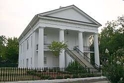 Kershaw County, South Carolina, original courthouse in Camden by Robert Mills built about 1827, now home of the Chamber of Commerce Visitor Center | |
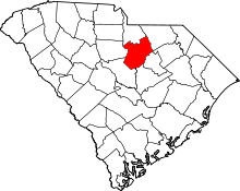 Location in the U.S. state of South Carolina | |
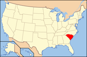 South Carolina's location in the U.S. | |
| Founded | 1791 |
| Named for | Joseph Brevard Kershaw |
| Seat | Camden |
| Largest city | Camden |
| Area | |
| • Total | 740 sq mi (1,917 km2) |
| • Land | 727 sq mi (1,883 km2) |
| • Water | 14 sq mi (36 km2), 1.9% |
| Population (est.) | |
| • (2016) | 64,097 |
| • Density | 85/sq mi (33/km2) |
| Congressional district | 5th |
| Time zone | Eastern: UTC−5/−4 |
| Website |
www |
Kershaw County is a county located in the U.S. state of South Carolina. As of the 2016 census, its population was 64,097.[1] The county seat and largest city is Camden.[2] The county was created in 1791 from parts of Claremont, Lancaster, Fairfield, and Richland counties.[3] It is named for Col. Joseph Kershaw (1727-1791), an early settler and American Revolutionary War patriot.
Kershaw County is part of the Columbia, South Carolina Metropolitan Statistical Area.
History
Kershaw County was named for Col. Joseph Kershaw (1727-1791), an early settler considered as "the father of Camden". Originally part of Camden District, Kershaw County was formed in 1791 from parts of Claremont, Lancaster, Fairfield, and Richland counties. The county seat is Camden, the oldest inland city in South Carolina. This site was settled around 1732 by English traders and farmers who moved inland from Charleston.
During the American Revolutionary War, the British occupied Camden from June 1780 to May 1781. Fourteen battles took place in the area, including the Battle of Camden (August 16, 1780) and the Battle of Hobkirk's Hill (April 25, 1781).
Kershaw County has a rich military history, producing several notable soldiers. The county produced six men who served in the American Civil War as Confederate generals: Joseph Brevard Kershaw (1822-1894), James Chesnut (1815-1885), James Cantey (1818-1873), Zachariah C. Deas (1819-1882), John Bordenave Villepigue (1830-1862), and John Doby Kennedy (1840-1896). Confederate soldier, and hero at the Battle of Fredericksburg, Richard Rowland Kirkland was also from Kershaw County, and served under General Kershaw. Union troops under Gen. William T. Sherman burned parts of Camden in February 1865.
During World War I, two Kershaw County men were awarded the Medal of Honor in two separate actions while fighting in France in October 1918. The first was Richmond Hobson Hilton, awarded his medal for actions taking place on October 11, 1918, during which he lost an arm. The second was John Canty Villepigue on October 15, 1918, in an action that resulted in his death months later from injuries received. Villepigue was a descendant of General John Bordenave Villepigue mentioned above.
Statesman and financier Bernard M. Baruch (1870-1965) and labor leader Lane Kirkland were born in Kershaw County, as was Larry Doby, the first African-American baseball player in the American League. Former South Carolina Governor John C. West was from Kershaw County.[4]
Geography
According to the U.S. Census Bureau, the county has a total area of 740 square miles (1,900 km2), of which 727 square miles (1,880 km2) is land and 14 square miles (36 km2) (1.9%) is water.[5] Kershaw County is one of three counties that compromises Lake Wateree, in which the lake is compromised with the Wateree River, which flows through Kershaw County.
Adjacent counties
- Richland County - southwest
- Lee County - southeast
- Fairfield County - west
- Lancaster County - north
- Chesterfield County - northeast
- Sumter County - southeast
- Darlington County - east
Parks and recreation
- Goodale State Park
- Lake Wateree Shaw AFB Recreational Area
National landmarks
Major highways
Demographics
| Historical population | |||
|---|---|---|---|
| Census | Pop. | %± | |
| 1800 | 7,340 | — | |
| 1810 | 9,867 | 34.4% | |
| 1820 | 12,432 | 26.0% | |
| 1830 | 13,545 | 9.0% | |
| 1840 | 12,281 | −9.3% | |
| 1850 | 14,473 | 17.8% | |
| 1860 | 13,086 | −9.6% | |
| 1870 | 11,754 | −10.2% | |
| 1880 | 21,538 | 83.2% | |
| 1890 | 22,361 | 3.8% | |
| 1900 | 24,696 | 10.4% | |
| 1910 | 27,094 | 9.7% | |
| 1920 | 29,398 | 8.5% | |
| 1930 | 32,070 | 9.1% | |
| 1940 | 32,913 | 2.6% | |
| 1950 | 32,287 | −1.9% | |
| 1960 | 33,585 | 4.0% | |
| 1970 | 34,727 | 3.4% | |
| 1980 | 39,015 | 12.3% | |
| 1990 | 43,599 | 11.7% | |
| 2000 | 52,647 | 20.8% | |
| 2010 | 61,697 | 17.2% | |
| Est. 2016 | 64,097 | [6] | 3.9% |
| U.S. Decennial Census[7] 1790-1960[8] 1900-1990[9] 1990-2000[10] 2010-2013[1] | |||
2000 census
As of the census[11] of 2000, there were 52,647 people, 20,188 households, and 14,918 families residing in the county. The population density was 72 people per square mile (28/km²). There were 22,683 housing units at an average density of 31 per square mile (12/km²). The racial makeup of the county was 71.61% White, 26.29% Black or African American, 0.29% Native American, 0.31% Asian, 0.03% Pacific Islander, 0.62% from other races, and 0.84% from two or more races. 1.68% of the population were Hispanic or Latino of any race.
There were 20,188 households out of which 33.70% had children under the age of 18 living with them, 55.80% were married couples living together, 13.60% had a female householder with no husband present, and 26.10% were non-families. 22.60% of all households were made up of individuals and 8.90% had someone living alone who was 65 years of age or older. The average household size was 2.58 and the average family size was 3.02.
In the county, the population was spread out with 26.10% under the age of 18, 7.60% from 18 to 24, 28.80% from 25 to 44, 24.50% from 45 to 64, and 12.90% who were 65 years of age or older. The median age was 37 years. For every 100 females, there were 93.40 males. For every 100 females age 18 and over, there were 90.00 males.
The median income for a household in the county was $38,804, and the median income for a family was $44,836. Males had a median income of $32,246 versus $22,714 for females. The per capita income for the county was $18,360. About 9.70% of families and 12.80% of the population were below the poverty line, including 16.90% of those under age 18 and 14.10% of those age 65 or over.
2010 census
As of the 2010 United States Census, there were 61,697 people, 23,928 households, and 17,114 families residing in the county.[12] The population density was 84.9 inhabitants per square mile (32.8/km2). There were 27,478 housing units at an average density of 37.8 per square mile (14.6/km2).[13] The racial makeup of the county was 71.3% white, 24.6% black or African American, 0.5% Asian, 0.3% American Indian, 1.7% from other races, and 1.6% from two or more races. Those of Hispanic or Latino origin made up 3.7% of the population.[12] In terms of ancestry, 28.1% were American, 7.8% were English, 7.7% were Irish, and 6.3% were German.[14]
Of the 23,928 households, 34.9% had children under the age of 18 living with them, 51.6% were married couples living together, 15.1% had a female householder with no husband present, 28.5% were non-families, and 24.5% of all households were made up of individuals. The average household size was 2.56 and the average family size was 3.02. The median age was 40.2 years.[12]
The median income for a household in the county was $44,064 and the median income for a family was $53,053. Males had a median income of $40,794 versus $30,553 for females. The per capita income for the county was $21,777. About 12.1% of families and 15.5% of the population were below the poverty line, including 21.6% of those under age 18 and 11.5% of those age 65 or over.[15]
Education
The Kershaw County School District serves as the governing body for all public schools in Kershaw County.
Central Carolina Technical College has two branches located in Camden.
Kershaw County is home to Camden Military Academy, the official state military academy of South Carolina. The Montessori School of Camden is a private school located in Camden.
High schools
- Camden High School
- Lugoff-Elgin High School
- North Central High School
- Applied Technology Education Campus
Middle schools
- Camden Middle School
- Lugoff-Elgin Middle School
- North Central Middle School
- Leslie M. Stover Middle School
Elementary schools
- Camden Elementary School
- Lugoff Elementary School
- Wateree Elementary School
- Blaney Elementary School
- Doby's Mill Elementary School
- Baron DeKalb Elementary School
- Mt. Pisgah Elementary School
- Midway Elementary School
- Pine Tree Hill Elementary School
- Jackson Elementary School
- Bethune Elementary School
Transportation
- Woodward Field (Kershaw County Airport)
- Camden station
Politics
| Year | Republican | Democratic | Third parties |
|---|---|---|---|
| 2016 | 60.5% 17,542 | 35.6% 10,330 | 3.9% 1,123 |
| 2012 | 58.4% 16,324 | 40.3% 11,259 | 1.3% 363 |
| 2008 | 58.8% 16,466 | 40.1% 11,226 | 1.1% 293 |
| 2004 | 61.8% 14,160 | 37.2% 8,515 | 1.1% 240 |
| 2000 | 60.5% 11,911 | 37.8% 7,428 | 1.7% 338 |
| 1996 | 52.1% 8,513 | 41.4% 6,764 | 6.6% 1,077 |
| 1992 | 49.1% 8,499 | 38.1% 6,585 | 12.8% 2,217 |
| 1988 | 65.9% 8,877 | 33.4% 4,494 | 0.8% 102 |
| 1984 | 66.7% 8,822 | 32.7% 4,323 | 0.6% 81 |
| 1980 | 55.6% 6,652 | 42.6% 5,103 | 1.8% 219 |
| 1976 | 49.4% 6,126 | 50.1% 6,211 | 0.5% 65 |
| 1972 | 74.8% 8,035 | 23.6% 2,531 | 1.7% 178 |
| 1968 | 38.6% 4,079 | 24.0% 2,539 | 37.4% 3,960 |
| 1964 | 63.9% 5,617 | 36.1% 3,168 | |
| 1960 | 52.2% 3,465 | 47.8% 3,178 | |
| 1956 | 28.2% 1,518 | 34.8% 1,875 | 37.0% 1,996 |
| 1952 | 58.9% 2,935 | 41.2% 2,052 | |
| 1948 | 2.5% 49 | 15.4% 302 | 82.2% 1,615 |
| 1944 | 1.1% 21 | 95.0% 1,872 | 4.0% 78 |
| 1940 | 1.7% 20 | 98.3% 1,174 | |
| 1936 | 1.4% 20 | 98.6% 1,400 | |
| 1932 | 0.8% 8 | 99.2% 1,051 | |
| 1928 | 1.1% 14 | 98.9% 1,274 | |
| 1924 | 0.1% 1 | 99.9% 733 | |
| 1920 | 3.5% 42 | 96.5% 1,156 | |
| 1916 | 1.4% 14 | 97.9% 989 | 0.7% 7 |
| 1912 | 1.0% 7 | 95.7% 708 | 3.4% 25 |
| 1904 | 2.9% 25 | 97.1% 850 | |
| 1900 | 4.5% 43 | 95.5% 910 |
Communities
City
- Camden (county seat)
Towns
Census-designated places
Unincorporated communities
- Antioch
- Cassatt
- DeKalb
- Liberty Hill
- Westville
- Mt. Pisgah
Gallery
 Original Kershaw County Courthouse in 1978
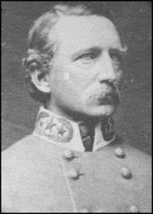
See also
References
- 1 2 "State & County QuickFacts". United States Census Bureau. Archived from the original on July 13, 2011. Retrieved November 22, 2013.
- ↑ "Find a County". National Association of Counties. Archived from the original on 2011-05-31. Retrieved 2011-06-07.
- ↑ "South Carolina: Individual County Chronologies". South Carolina Atlas of Historical County Boundaries. The Newberry Library. 2009. Retrieved March 21, 2015.
- ↑ South Carolina State Library Reference Room
- ↑ "2010 Census Gazetteer Files". United States Census Bureau. August 22, 2012. Retrieved March 18, 2015.
- ↑ "Population and Housing Unit Estimates". Retrieved June 9, 2017.
- ↑ "U.S. Decennial Census". United States Census Bureau. Archived from the original on May 12, 2015. Retrieved March 18, 2015.
- ↑ "Historical Census Browser". University of Virginia Library. Retrieved March 18, 2015.
- ↑ Forstall, Richard L., ed. (March 27, 1995). "Population of Counties by Decennial Census: 1900 to 1990". United States Census Bureau. Retrieved March 18, 2015.
- ↑ "Census 2000 PHC-T-4. Ranking Tables for Counties: 1990 and 2000" (PDF). United States Census Bureau. April 2, 2001. Retrieved March 18, 2015.
- ↑ "American FactFinder". United States Census Bureau. Retrieved 2011-05-14.
- 1 2 3 "DP-1 Profile of General Population and Housing Characteristics: 2010 Demographic Profile Data". United States Census Bureau. Retrieved 2016-03-11.
- ↑ "Population, Housing Units, Area, and Density: 2010 - County". United States Census Bureau. Retrieved 2016-03-11.
- ↑ "DP02 SELECTED SOCIAL CHARACTERISTICS IN THE UNITED STATES – 2006-2010 American Community Survey 5-Year Estimates". United States Census Bureau. Retrieved 2016-03-11.
- ↑ "DP03 SELECTED ECONOMIC CHARACTERISTICS – 2006-2010 American Community Survey 5-Year Estimates". United States Census Bureau. Retrieved 2016-03-11.
- ↑ Leip, David. "Dave Leip's Atlas of U.S. Presidential Elections". uselectionatlas.org. Retrieved 2018-03-13.
External links
Places adjacent to Kershaw County, South Carolina | ||||||||||
|---|---|---|---|---|---|---|---|---|---|---|
| ||||||||||
Municipalities and communities of Kershaw County, South Carolina, United States | ||
|---|---|---|
| City | | |
| Towns | ||
| CDPs | ||
| Unincorporated communities | ||