Abbeville, South Carolina
| Abbeville, South Carolina | |
|---|---|
| City | |
 | |
| Motto(s): "Pretty. Near. Perfect." | |
 Abbeville Location within the state of South Carolina | |
| Coordinates: 34°10′42.7584″N 82°22′39.6732″W / 34.178544000°N 82.377687000°WCoordinates: 34°10′42.7584″N 82°22′39.6732″W / 34.178544000°N 82.377687000°W | |
| Country | United States |
| State | South Carolina |
| County | Abbeville |
| Government | |
| • Mayor | Delano Freeman |
| Area | |
| • Total | 6.13 sq mi (15.87 km2) |
| • Land | 6.12 sq mi (15.84 km2) |
| • Water | 0.01 sq mi (0.03 km2) |
| Elevation | 591 ft (180 m) |
| Population (2010) | |
| • Total | 5,237 |
| • Density | 856/sq mi (330.6/km2) |
| Time zone | UTC−5 (Eastern (EST)) |
| • Summer (DST) | UTC−4 (EDT) |
| ZIP code | 29620 |
| Area code(s) | 864 |
| FIPS code | 45-00100[1] |
| GNIS feature ID | 1244839[2] |
| Website |
www |
Abbeville is a city in Abbeville County, South Carolina, United States, 86 miles (138 km) west of Columbia and 45 miles (72 km) south of Greenville.[3] Its population was 5,237 at the 2010 census.[1] It is the county seat of Abbeville County.[4][5] Settled by French Huguenot settlers, it was named, along with the county, for the French town of the same name.[3][6]
History
Abbeville was established by French Huguenots in 1764,[5] at a site named by John de la Howe.[5] It was incorporated in 1840.[3]
Famed states' rights advocate and Vice President John C. Calhoun first practiced law in Abbeville, and he was born on a farm on the outskirts[5] in what is now Mt. Carmel.[7]
Anthony Crawford was lynched here in 1916.
Abbeville and the American Civil War

Abbeville has the unique distinction of being both the birthplace and the deathbed of the Confederacy. On November 22, 1860, a meeting was held at Abbeville, at a site since dubbed "Secession Hill", to launch South Carolina's secession from the Union;[8][9] one month later, the state of South Carolina became the first state to secede.
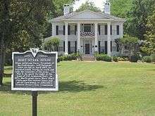
At the end of the Civil War, with the Confederacy in shambles, Confederate President Jefferson Davis fled Richmond, Virginia, and headed south, stopping for a night in Abbeville at the home of his friend Armistead Burt. It was on May 2, 1865, in the front parlor of what is now known as the Burt-Stark Mansion that Jefferson Davis officially acknowledged the dissolution of the Confederate government, in the last official cabinet meeting.[8][9]
2003 right-of-way standoff
On December 8, 2003, in a 14-hour standoff that stemmed from a land-survey dispute, two Abbeville lawmen were killed by West Abbeville resident Steven Bixby. This siege has been compared by both sympathizers of the Bixbys and law enforcement agents to the events of Waco and Ruby Ridge.[10] In February 2007, Steven Bixby was convicted on 17 counts including the two murders, as well as lesser charges of kidnapping and conspiracy. He was given two death sentences for the murders plus 125 years in prison on the other charges.
Architectural mention
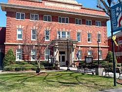
The Abbeville County Courthouse, Abbeville Historic District, Abbeville Opera House, Armistead Burt House, Patrick Calhoun Family Cemetery, Cedar Springs Historic District, Harbison College President's Home, Trinity Episcopal Church and Cemetery and Upper Long Cane Cemetery are listed on the National Register of Historic Places.[11][12]
Abbeville is also the location of the tallest building in South Carolina, the Prysmian Copper Wire Tower. Built in 2009, the tower is 373 feet (114 m) tall and has 30 floors.[13]
Notable people
- John C. Calhoun, (1782-1850), 7th American Vice President, 16th U.S. Secretary of State; born near Abbeville and also practiced law in Abbeville.[7][14]
- James S. Cothran (1830–1897), born near Abbeville, practiced law in Abbeville, confederate officer, judge, and United States Congressman from South Carolina, buried at Upper Long Cane Cemetery.[15][16]
- Thomas D. Howie (April 12, 1908 – July 17, 1944), American army officer killed during the Normandy Campaign of World War II while trying to capture the French town of Saint-Lô. He is known as "The Major of St. Lo".
- John Henry Logan (1822–1885), born in Abbeville, editor of Abbeville Banner newspaper, physician, served as a surgeon in the Confederate Army during the American Civil War, professor at Atlanta Medical College, and editor of the Atlanta Medical Journal[17]
- Samuel McGowan (general) (1819-1897), born in Laurens County, SC; Confederate General wounded four times. Post-war leader against "carpetbagger" rule; South Carolina Supreme Court associate justice.
- Benjamin Glover Shields (1808–1850), born in Abbeville, United States Congressman from Alabama, diplomat to Venezuela[18][19]
- William Washington Vance (1849-1900), Louisiana state senator and gubernatorial private secretary; born in Cokesbury, studied law privately in Abbeville in the 1870s[20]
Geography
Abbeville is located at 34°10′42.7584″N 82°22′39.6732″W / 34.178544000°N 82.377687000°W,[21] and is within the Piedmont Upland geographical region.[3][8]
According to the United States Census Bureau, the city has a total area of 6.1 square miles (15.9 km2), of which 0.012 square miles (0.03 km2), or 0.19%, is water.[1]
Nearby is the Sumter National Forest.[5]
Climate
Abbeville has a humid subtropical climate (Köppen Cfa). Winters are cool, sometimes cold, and short in duration. Summers are hot and humid. The transitional seasons of spring and fall can vary in temperature but tend to be warm. In the summer highs usually peak in the mid 90s, but temperatures over 100 °F (37.8 °C) occur on occasion, most recently in the summer of 2012 during a heat wave. That year, the all-time record high of 109 °F (42.8 °C) was recorded on July 1.[22] In the winter highs are in the low to mid 50s and lows are right around freezing, seldom dropping below 25 °F (−3.9 °C). Precipitation is well distributed throughout the year. Afternoon thunderstorms are a common occurrence in the summer months and can bring heavy winds and lightning. Snow is rare, falling every few years. On March 31, 1973, an F4 tornado struck Abbeville and killed 7 people, making it the deadliest single tornado in 1973.[23] The area was struck by two tornadoes on April 10, 2009. No fatalities were recorded, but the majority of the city lost power and many buildings sustained significant damage.[23][24]
| Climate data for Abbeville, SC | |||||||||||||
|---|---|---|---|---|---|---|---|---|---|---|---|---|---|
| Month | Jan | Feb | Mar | Apr | May | Jun | Jul | Aug | Sep | Oct | Nov | Dec | Year |
| Record high °F (°C) | 82 (28) |
80 (27) |
89 (32) |
92 (33) |
97 (36) |
105 (41) |
109 (43) |
107 (42) |
104 (40) |
100 (38) |
89 (32) |
78 (26) |
109 (43) |
| Average high °F (°C) | 53 (12) |
58 (14) |
66 (19) |
74 (23) |
82 (28) |
88 (31) |
91 (33) |
90 (32) |
84 (29) |
74 (23) |
65 (18) |
55 (13) |
73 (23) |
| Average low °F (°C) | 31 (−1) |
34 (1) |
40 (4) |
48 (9) |
57 (14) |
66 (19) |
70 (21) |
69 (21) |
62 (17) |
50 (10) |
41 (5) |
33 (1) |
50 (10) |
| Record low °F (°C) | −2 (−19) |
2 (−17) |
3 (−16) |
24 (−4) |
32 (0) |
41 (5) |
53 (12) |
50 (10) |
35 (2) |
25 (−4) |
13 (−11) |
1 (−17) |
−2 (−19) |
| Average precipitation inches (mm) | 4.16 (105.7) |
4.60 (116.8) |
4.68 (118.9) |
2.85 (72.4) |
3.40 (86.4) |
3.45 (87.6) |
4.01 (101.9) |
3.68 (93.5) |
3.11 (79) |
3.45 (87.6) |
3.62 (91.9) |
3.76 (95.5) |
44.77 (1,137.2) |
| Source: [25] | |||||||||||||
Demographics
| Historical population | |||
|---|---|---|---|
| Census | Pop. | %± | |
| 1850 | 1,251 | — | |
| 1860 | 592 | −52.7% | |
| 1880 | 1,543 | — | |
| 1890 | 1,696 | 9.9% | |
| 1900 | 3,766 | 122.1% | |
| 1910 | 4,459 | 18.4% | |
| 1920 | 4,570 | 2.5% | |
| 1930 | 4,414 | −3.4% | |
| 1940 | 4,930 | 11.7% | |
| 1950 | 5,395 | 9.4% | |
| 1960 | 5,436 | 0.8% | |
| 1970 | 5,515 | 1.5% | |
| 1980 | 5,833 | 5.8% | |
| 1990 | 5,778 | −0.9% | |
| 2000 | 5,840 | 1.1% | |
| 2010 | 5,237 | −10.3% | |
| Est. 2016 | 5,168 | [26] | −1.3% |
| U.S. Decennial Census | |||
2000
As of the census[1] of 2000, there were 5,840 people, 2,396 households, and 1,574 families residing in the city. The population density was 995.2 people per square mile (384.1/km²). There were 2,654 housing units at an average density of 452.3 per square mile (174.6/km²). The racial makeup of the city was 50.46% White, 48.48% African American, 0.12% Native American, 0.26% Asian, 0.02% Pacific Islander, 0.19% from other races, and 0.48% from two or more races. Hispanic or Latino of any race were 0.75% of the population.
There were 2,396 households out of which 30.7% had children under the age of 18 living with them, 37.1% were married couples living together, 23.9% had a female householder with no husband present, and 34.3% were non-families. 30.6% of all households were made up of individuals and 13.9% had someone living alone who was 65 years of age or older. The average household size was 2.39 and the average family size was 2.97.
In the city, the population was spread out with 27.2% under the age of 18, 8.8% from 18 to 24, 25.9% from 25 to 44, 21.2% from 45 to 64, and 16.8% who were 65 years of age or older. The median age was 36 years. For every 100 females, there were 80.4 males. For every 100 females age 18 and over, there were 73.9 males.
The median income for a household in the city was $25,756, and the median income for a family was $30,040. Males had a median income of $28,339 versus $21,824 for females. The per capita income for the city was $13,274. About 16.3% of families and 19.8% of the population were below the poverty line, including 29.2% of those under age 18 and 20.9% of those age 65 or over.
Abbeville is the center of a small urban cluster with a total population of 6,038 (2000 census).
2010
As of the 2010 census[27] the population of Abbeville was 5,237. The racial composition of the city was 46.9% White, 50.5% Black or African American, 0.9% Hispanic or Latino (of any race), 0.4% Asian, 0.2% Native American, 0.4% of other races, and 1.5% of Two or more races.
Economy
Agriculture and forestry are important industries in the area. Crops that are grown in quantities are cotton, soybeans, corn, oats, wheat, and peaches. Livestock, dairy cows, and poultry are also raised in the area. Finally textiles are the chief manufactured product, in particular, clothing. After the North American Free Trade Agreement clothing is no longer made in Abbeville. Also represented are plastic and metal products.[3][8]
See also
Footnotes
- 1 2 3 4 Anon 2014
- ↑ Anon 2015
- 1 2 3 4 5 Johnston 1997, p. 8
- ↑ Anon 2014a
- 1 2 3 4 5 Hoiberg 2010, p. 11
- ↑ Gannett 1905, p. 22
- 1 2 Ragsdale, Jacob & Nystrom 1989, p. 729
- 1 2 3 4 Cohen 1998, p. 3
- 1 2 Canby 1984, p. 2
- ↑ Anon 2003, p. 2
- ↑ Anon 2011a
- ↑ The Historic American Buildings Survey & Historic American Engineering Record 1995, p. 899
- ↑ Anon 2015a
- ↑ Galgoul, Wilson & Konya 1967, p. 160
- ↑ Galgoul, Wilson & Konya 1967, p. 192
- ↑ Ragsdale, Jacob & Nystrom 1989, p. 831
- ↑ Galgoul, Wilson & Konya 1967, p. 389
- ↑ Galgoul, Wilson & Konya 1967, p. 552
- ↑ Ragsdale, Jacob & Nystrom 1989, p. 1805
- ↑ Anon 1900
- ↑ Anon 2015b
- ↑ Anon 2012
- 1 2 Lietz 2015
- ↑ Anon 2009
- ↑ Anon 2014b
- ↑ "Population and Housing Unit Estimates". Retrieved June 9, 2017.
- ↑ "American FactFinder". United States Census Bureau. Retrieved 2017-04-12.
References
- Anon (2015). "Feature Detail Report for: Abbeville". Geographic Names Information System (GNIS). United States Geological Survey. Archived from the original on 2015-05-10. Retrieved May 10, 2015.
- Anon (October 21, 2015a). "Prysmian Unveils Nation's First Extra-high Voltage Cable Plant, State's Tallest Building in Abbeville". GSA Business. SC Biz News. Archived from the original on 2015-05-11. Retrieved May 10, 2015.
- Anon (March 24, 2015b). "National Places Gazetteer Files (2014)" (Text). United States Census Bureau. Archived from the original on 2015-05-11. Retrieved May 10, 2015.
- Anon (2014). "Abbeville City, South Carolina". American FactFinder. United States Census Bureau. Retrieved May 10, 2015.
- Anon (2014a). "Find a County: Abbeville County, SC". National Association of Counties. Washington, DC: National Association of Counties. Archived from the original on 2015-05-10. Retrieved May 10, 2015.
- Anon (2014b). "Average Weather for Abbeville, SC – Temperature and Precipitation". Weather.com.
- Anon (2012). "Record Temperature". National Weather Service.
- Anon (2011a). "Listed Properties as of October 1, 2011" (XLS). National Register of Historic Places. National Park Service. Archived from the original on 2015-05-11. Retrieved May 10, 2015.
- Anon (2014). "Race and Hispanic or Latino Origin: 2010: Abbeville City, South Carolina". American FactFinder. United States Census Bureau. Retrieved May 10, 2015.
- Anon (April 13, 2009). "Abbeville, SC Hit Hard by Friday Night's Storms". WJBF. Augusta, GA: Media General Communications Holdings. Archived from the original on May 18, 2015. Retrieved May 10, 2015.
- Anon (December 10, 2003). "Tragedy in Abbeville". The Index-Journal. Greenwood, SC. Retrieved May 11, 2015. (Subscription required (help)).
- Anon (February 17, 1900). "William Washington Vance". The Daily Advocate. Baton Rouge, LA. Archived from the original on May 11, 2015.
- Canby, Courtlandt, ed. (1984). "Abbeville". Encyclopedia of Historic Places. I: A-L. New York, NY: Facts on File Publications. ISBN 0-87196-397-3. LCCN 80025121.
- Cohen, Saul B., ed. (1998). "Abbeville". The Columbia Gazetteer of the World. 1: A to G. New York, NY: Columbia University Press. ISBN 0-231-11040-5. LCCN 98071262.
- Galgoul, Barbara Wardell; Wilson, Juanita; Konya, Rose, eds. (1967). Who Was Who in America: Historic Volume 1607-1896 (Revised ed.). Chicago, IL: A. N. Marquis Company. LCCN 43003789.
- Gannett, Henry (1905). The Origin of Certain Place Names in the United States (PDF) (2nd ed.). Washington, DC: Government Printing Office. LCCN 05000751.
- Hoiberg, Dale H., ed. (2010). "Abbeville". Encyclopædia Britannica. 1: A-ak Bayes (15th ed.). Chicago, IL: Encyclopædia Britannica, Inc. ISBN 978-1-5933-9837-8. LCCN 2008934270.
- Johnston, Bernard, ed. (1997). "Abbeville". Collier's Encyclopedia. I: A to Ameland (1st ed.). New York, NY: P. F. Collier. LCCN 96084127.
- Lietz, Joshua (2015). "Tornadoes in Abbeville County, South Carolina". Tornado History Project. Retrieved May 10, 2015.
- Ragsdale, Bruce A.; Jacob, Kathryn Allamong; Nystrom, Duane, eds. (1989). Biographical Directory of the United States Congress: 1774-1989 (Bicentennial ed.). Washington, DC: United States Government Printing Office. LCCN 88600335.
- The Historic American Buildings Survey; Historic American Engineering Record (1995). America Preserved: A Checklist of Historic Buildings, Structures, and Sites. Washington, DC: Library of Congress, Cataloging Distribution Service. ISBN 0-16-045255-4. LCCN 94019453.
External links
| Wikisource has the text of a 1921 Collier's Encyclopedia article about Abbeville. |
Municipalities and communities of Abbeville County, South Carolina, United States | ||
|---|---|---|
| City | 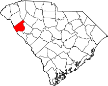 | |
| Towns | ||
| CDPs | ||
| Footnotes | ‡This populated place also has portions in an adjacent county or counties | |