Irmo, South Carolina
| Irmo, South Carolina | |
|---|---|
| Town | |
| Motto(s): "Gateway to Lake Murray and Tree City USA" | |
 Location in Richland County and the state of South Carolina. | |
| Coordinates: 34°05′10″N 81°10′59″W / 34.08611°N 81.18306°WCoordinates: 34°05′10″N 81°10′59″W / 34.08611°N 81.18306°W | |
| Country | United States |
| State | South Carolina |
| Counties | Lexington, Richland |
| Area | |
| • Total | 6.3 sq mi (16.2 km2) |
| • Land | 6.3 sq mi (16.2 km2) |
| • Water | 0 sq mi (0 km2) |
| Elevation | 358 ft (109 m) |
| Population (2010) | |
| • Total | 11,097 |
| • Density | 1,800/sq mi (690/km2) |
| Time zone | UTC-5 (EST) |
| • Summer (DST) | UTC-4 (EDT) |
| ZIP code | 29063 |
| Area code(s) | 803 |
| FIPS code | 45-35890[1] |
| GNIS feature ID | 1231420[2] |
| Demonym | Irmite |
| Website |
www |
Irmo is a town in Lexington and Richland counties, South Carolina, United States and a suburb of Columbia. It is part of the Columbia Metropolitan Statistical Area and is located 12 miles (19 km) northwest of the city center. The population of Irmo was 11,097 at the 2010 census.[3]
History
Irmo was chartered on Christmas Eve in 1890 in response to the opening of the Columbia, Newberry and Laurens Railroad. The name of Irmo was the result of combining the names of Captain C.J. Iredell and Henry Moseley, two important figures in the founding of the town. Despite the town's growth, Irmo does not have an actual downtown area. Rather, it consists of several clusters of suburban neighborhoods. Columbiana Centre mall was built in 1990, which led to the growth of the Harbison area.
The Jacob Wingard Dreher House was listed on the U.S. National Register of Historic Places in 1983.[4]
Geography
According to the United States Census Bureau, the town has a total area of 6.3 square miles (16.2 km2), all land.[3]
Demographics
| Historical population | |||
|---|---|---|---|
| Census | Pop. | %± | |
| 1900 | 193 | — | |
| 1910 | 267 | 38.3% | |
| 1920 | 236 | −11.6% | |
| 1930 | 365 | 54.7% | |
| 1940 | 230 | −37.0% | |
| 1950 | 281 | 22.2% | |
| 1960 | 359 | 27.8% | |
| 1970 | 517 | 44.0% | |
| 1980 | 3,957 | 665.4% | |
| 1990 | 11,280 | 185.1% | |
| 2000 | 11,039 | −2.1% | |
| 2010 | 11,097 | 0.5% | |
| Est. 2016 | 12,177 | [5] | 9.7% |
| U.S. Decennial Census[6] | |||
As of the census[1] of 2000, there were 11,039 people, 3,911 households, and 3,163 families residing in the town. The population density was 2,670.2 people per square mile (1,032.0/km2). There were 4,066 housing units at an average density of 983.5 per square mile (380.1/km2). The racial makeup of the town was 76.76% White, 20.16% African American, 0.25% Native American, 1.43% Asian, 0.08% Pacific Islander, 0.44% from other races, and 0.88% from two or more races. Hispanic or Latino of any race were 1.42% of the population.
There were 3,911 households out of which 47.7% had children under the age of 18 living with them, 65.9% were married couples living together, 12.0% had a female householder with no husband present, and 19.1% were non-families. 15.4% of all households were made up of individuals and 2.6% had someone living alone who was 65 years of age or older. The average household size was 2.81 and the average family size was 3.15.
In the town, the population was spread out with 30.7% under the age of 18, 6.6% from 18 to 24, 34.6% from 25 to 44, 23.3% from 45 to 64, and 4.8% who were 65 years of age or older. The median age was 34 years. For every 100 females, there were 93.6 males. For every 100 females age 18 and over, there were 88.7 males.
The median income for a household in the town was $55,847, and the median income for a family was $62,005. Males had a median income of $41,054 versus $30,171 for females. The per capita income for the town was $22,312. About 3.3% of families and 4.3% of the population were below the poverty line, including 4.4% of those under age 18 and 11.6% of those age 65 or over.
Arts and culture
The Okra Strut is an annual festival started in 1973 as a fundraising effort for a new library. Named for the okra plant, events have included a charity golf tournament, street dance, live entertainment, a midway, cycling and running competitions, arts and crafts exhibits, and a parade.[7]
Notable people
- Ben Bridwell (born 1978), lead singer of the Grammy-nominated indie Band of Horses known for Laredo (song), grew up in Irmo.
- The Movement, reggae-rock group; members attended Irmo High School
- Leeza Gibbons (born 1957), talk show host
- Dustin Johnson (born 1984), professional golfer; won the 2016 U.S. Open; ranked #1 golfer in the world; attended Dutch Fork High School
- B.J. McKie (born 1977), professional basketball player; leading scorer all-time for the University of South Carolina's Gamecock basketball team
- Courtney Shealy (born 1977), swimmer, 2000 Olympic Gold Medalist
- Alaina Coates (born 1995), professional basketball player
References
- 1 2 "American FactFinder". United States Census Bureau. Retrieved 2008-01-31.
- ↑ U.S. Geological Survey Geographic Names Information System: Irmo
- 1 2 "Geographic Identifiers: 2010 Demographic Profile Data (G001): Irmo town, South Carolina". U.S. Census Bureau, American Factfinder. Retrieved January 14, 2013.
- ↑ National Park Service (2009-03-13). "National Register Information System". National Register of Historic Places. National Park Service.
- ↑ "Population and Housing Unit Estimates". Retrieved June 9, 2017.
- ↑ "Census of Population and Housing". Census.gov. Archived from the original on May 12, 2015. Retrieved June 4, 2015.
- ↑ "The Irmo Okra Strut". Town of Irmo. Retrieved December 30, 2017.
External links
Municipalities and communities of Lexington County, South Carolina, United States | ||
|---|---|---|
| Cities | 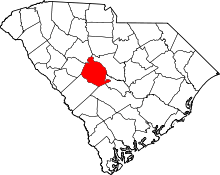 | |
| Towns | ||
| CDPs | ||
| Ghost town | ||
| Footnotes | ‡This populated place also has portions in an adjacent county or counties | |
Municipalities and communities of Richland County, South Carolina, United States | ||
|---|---|---|
| Cities | 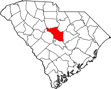 | |
| Towns | ||
| CDPs | ||
| Unincorporated communities | ||
| Footnotes | ‡This populated place also has portions in an adjacent county or counties | |