Chesterfield, South Carolina
| Chesterfield, South Carolina | |
|---|---|
| Town | |
| Motto(s): "The Heart of the Carolinas" | |
 Location of Chesterfield, South Carolina | |
| Coordinates: 34°44′1″N 80°5′20″W / 34.73361°N 80.08889°WCoordinates: 34°44′1″N 80°5′20″W / 34.73361°N 80.08889°W | |
| Country | United States |
| State | South Carolina |
| County | Chesterfield |
| Area | |
| • Total | 4.1 sq mi (10.5 km2) |
| • Land | 4.1 sq mi (10.5 km2) |
| • Water | 0.0 sq mi (0.0 km2) |
| Elevation | 292 ft (89 m) |
| Population (2010) | |
| • Total | 1,472 |
| • Density | 364/sq mi (140.5/km2) |
| Time zone | UTC-5 (Eastern (EST)) |
| • Summer (DST) | UTC-4 (EDT) |
| ZIP code | 29709 |
| Area code(s) | 843 |
| FIPS code | 45-14140[1] |
| GNIS feature ID | 1231164[2] |
| Website |
chesterfield-sc |
Chesterfield is a town in Chesterfield County, South Carolina, United States. The population was 1,472 at the 2010 census.[3] It is the county seat of Chesterfield County.[4] At the time of the 2010 census, Chesterfield was the least populous of all of South Carolina's county seats but was second only to Florence in growth rate among municipalities of 1,000 or more residents since 2000 in the Pee Dee region.
History
Chesterfield was established in 1785 when the County Court Act divided St. David's Parish into three districts and a court house was designated for Chesterfield County. Chesterfield, originally known as "Chesterfield Court House," has an active past that is an important part of its present with a positive influence on its future.
Many of the homes and buildings that are preserved from the 1700s through the early 1900s give a glimpse into the proud heritage of the fine citizens of this area.
Dr. W. J. Perry House, 321 East Main Street. This house was built in 1914-15 for Dr. Perry and of note are the tin ceilings. The house was home to the County Department of Social Services from 1952-1978.
Chesterfield Baptist Church, corner of East Main Street and Craig Street. This imposing brick edifice was constructed in 1928. In 1933, the bell from the Old Church was donated to Wake Forest University.
John Craig House, 203 East Main Street. This home was completed in 1798 by the town's first settler, John Craig. The oldest house in town, it was used by Union Army General William T. Sherman as his headquarters during his stay here in the American Civil War during his March northward from the Atlantic coast at Savannah, Georgia, continuing his famous "March to the Sea" southeast from Atlanta, then heading north through the Carolinas to the surrender of the second Confederate Army in the Eastern Theater under Gen. Joseph E. Johnston in April 1865, at Bennett Place near Durham, North Carolina.
U.S. Post Office, corner of East Main Street and Scotch Road. The grounds of this building, built in 1937, were once home to an Indian trading post. Inside is a fine example of New Deal Art, a relief sculpture "The Farmer's Letters." The Sculpture is one of only two such sculptures commissioned for post offices in the "Palmetto State".
1884 County Court House, 100 Main Street. This building, with its imposing cupola, was built to replace the previous 1825 courthouse which was burned by Sherman's Northern troops near the end of the Civil War. A monument on the grounds marks the site of the first secession meeting held in the South preceding the Civil War.
Old County Jail, 100 West Main Street This building was built in 1885 as a jail and as a residence for the county sheriff. Its steps are made from granite salvaged from the 1825 Courthouse burned in the Civil War. It is now used for offices.
Bank of Chesterfield building, 110 Main Street. Constructed in 1908 near the peak of the town's prosperity following the completion of railroad service, this building once served as the town's police department and is now a restaurant.
County Court House 200 West Main Street. This modern building was completed in 1977 as the center of Chesterfield County government. The main lobby features a large second story skylight.
Austin-Craig House 302 West Main Street. This house was completed in 1858 as a residence for James Austin, a lawyer from Pennsylvania. According to legend, Union troops attempted to burn the house during the Civil War but stopped when told by a slave woman it was built for a "Yankee." Evidence of the fire remains visible.
St. Paul United Methodist Church, 305 West Main Street. The First Methodist Church in Chesterfield was organized in 1930 and was called the Courthouse Methodist Church. The present Gothic Revival building was completed in 1905.
John T. Hurst House, 306 West Main Street. This Colonial Revival-influenced house was built in 1904 for a local merchant. The facade is built of handmade Pennsylvania brick while the back is made of local brick.
B. C. Moore House 312 West Main Street. This house, currently under renovation, was built in 1914 for the founder of the B.C. Moore department store chain. The porches and gables are of interest.
Dr. Dewett Thompson Teal House, 508 West Main Street.. This imposing residence was built in 1921 for Dr. Teal. He once supplied electricity to the town. Ironing could only be done at certain times to conserve electricity.
Dr. Thomas E. Lucas House, 716 West Main Street. This house was built in 1868 for Dr. Lucas, a member of the South Carolina House of Representatives. According to legend, he made the money to build the home while serving as a doctor to Union troops stationed here following the Civil War.
Mt. Tabor United Methodist Church, West Boulevard. This church building was completed in 1878. According to legend, a group of Black freedmen met in a brush arbor before erecting a building. The grounds contain the original church bell. The building now houses the Rivers Church.
Old Mall, 109 Church Street. The "Carolina Hotel" was completed in 1900. It housed a general merchandise store, hotel, market and bank. It is referred to as The Old Mall. It is now an apartment complex.
William Duke Craig House, Mill Street. This house, built c. 1820, stood on the site of the 1977 Court House before being moved here. Craig, who owned the nearby Craig's Grist Mill, donated the land for Craig Park.
Craig Park Between Page Street and Park Drive. Completed in 1935, in the Great Depression as a WPA (Works Progress Administration) project, this park was built on lands donated by William Duke Craig. The park area includes picnic facilities, playground, amphitheater and community house and is especially inviting in spring when dogwood, the town tree, is in bloom.
Chesterfield Presbyterian Church West Main Street. Established in 1908. The history of the church originates in 1889 with nine members. In 1894 the church discontinued services, then reorganized in 1908 with 15 members.
Old Court House and School, 601 West Main Street. This building, now a residence, was constructed as a temporary replacement to the 1825 court house burned in the Civil War. It was moved to its present location around 1900 and converted into a school.
When known as "Chesterfield Court House", the town was granted a United States Post Office on July 1, 1804, and its first Postmaster was Mr. John Craig. On December 12, 1893, the name of the town was officially changed simply to Chesterfield. It has been in continuous operation ever since its inception in 1804.
The East Main Street Historic District, Dr. Thomas E. Lucas House, and West Main Street Historic District are listed on the National Register of Historic Places, supervised by the National Park Service of the U.S. Department of the Interior.[5]
Geography
Chesterfield is located in northeastern Chesterfield County at 34°44′1″N 80°5′20″W / 34.73361°N 80.08889°W (34.733626, -80.088945).[6] According to the United States Census Bureau, the town has a total area of 4.1 square miles (10.5 km2), all land.[3]
South Carolina Highway 9 passes through the town, leading east 12 miles (19 km) to Cheraw and west 19 miles (31 km) to Pageland. South Carolina Highway 145 crosses SC 9 near the center of town, leading southwest 21 miles (34 km) to McBee and northeast 10 miles (16 km) to Morven, North Carolina. South Carolina Highway 102 leads south from Chesterfield 12 miles (19 km) to Patrick.
Demographics
| Historical population | |||
|---|---|---|---|
| Census | Pop. | %± | |
| 1900 | 308 | — | |
| 1910 | 618 | 100.6% | |
| 1920 | 856 | 38.5% | |
| 1930 | 1,030 | 20.3% | |
| 1940 | 1,263 | 22.6% | |
| 1950 | 1,530 | 21.1% | |
| 1960 | 1,532 | 0.1% | |
| 1970 | 1,667 | 8.8% | |
| 1980 | 1,432 | −14.1% | |
| 1990 | 1,373 | −4.1% | |
| 2000 | 1,318 | −4.0% | |
| 2010 | 1,472 | 11.7% | |
| Est. 2016 | 1,452 | [7] | −1.4% |
| U.S. Decennial Census | |||
As of the census[1] of 2000, there were 1472 people, 597 households, and 358 families residing in the town. The population density was 383.2 people per square mile (147.9/km²). There were 683 housing units at an average density of 198.6 per square mile (76.7/km²). The racial makeup of the town was 64.64% White, 34.67% African American, 0.15% Native American, 0.09% Asian, 0.29% from other races, and 0.15% from two or more races. Hispanic or Latino of any race were 0.83% of the population.
There were 597 households out of which 28.1% had children under the age of 18 living with them, 38.5% were married couples living together, 19.8% had a female householder with no husband present, and 39.9% were non-families. 37.2% of all households were made up of individuals and 17.8% had someone living alone who was 65 years of age or older. The average household size was 2.19 and the average family size was 2.86.
In the town, the population was spread out with 23.2% under the age of 18, 7.7% from 18 to 24, 25.7% from 25 to 44, 24.9% from 45 to 64, and 18.5% who were 65 years of age or older. The median age was 41 years. For every 100 females, there were 81.5 males. For every 100 females age 18 and over, there were 73.0 males.
The median income for a household in the town was $25,833, and the median income for a family was $36,806. Males had a median income of $31,488 versus $20,625 for females. The per capita income for the town was $16,481. About 19.7% of families and 23.7% of the population were below the poverty line, including 39.0% of those under age 18 and 22.2% of those age 65 or over.
Geology
The "great syenite dyke" extends from Hanging Rock through Taxahaw to the Brewer and Edgeworth mine in Chesterfield.[8]
See also
References
- 1 2 "American FactFinder". United States Census Bureau. Archived from the original on 2013-09-11. Retrieved 2008-01-31.
- ↑ "US Board on Geographic Names". United States Geological Survey. 2007-10-25. Retrieved 2008-01-31.
- 1 2 "Geographic Identifiers: 2010 Census Summary File 1 (G001): Chesterfield town, South Carolina". U.S. Census Bureau, American Factfinder. Retrieved July 1, 2015.
- ↑ "Find a County". National Association of Counties. Archived from the original on 2015-05-10. Retrieved 2011-06-07.
- ↑ National Park Service (2010-07-09). "National Register Information System". National Register of Historic Places. National Park Service.
- ↑ "US Gazetteer files: 2010, 2000, and 1990". United States Census Bureau. 2011-02-12. Retrieved 2011-04-23.
- ↑ "Population and Housing Unit Estimates". Retrieved June 9, 2017.
- ↑ Lieber, Oscar Montgomery (1856). Report on the Survey of South Carolina. South Carolina General Assembly. p. 32. Retrieved 2 December 2014.
External links
Municipalities and communities of Chesterfield County, South Carolina, United States | ||
|---|---|---|
| Towns | 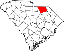 | |
| Unincorporated communities | ||
| Ghost towns | ||
| Footnotes | ‡This populated place also has portions in an adjacent county or counties | |