Conway, South Carolina
| Conway, South Carolina | ||
|---|---|---|
| City | ||
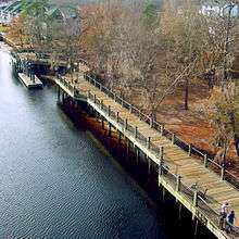
 The Riverwalk in downtown Conway | ||
| ||
| Nickname(s): "Historic Rivertown"[1] | ||
 Location of Conway in South Carolina | ||
| Coordinates: 33°50′17″N 79°3′22″W / 33.83806°N 79.05611°WCoordinates: 33°50′17″N 79°3′22″W / 33.83806°N 79.05611°W | ||
| Country | United States | |
| State | South Carolina | |
| County | Horry | |
| Government | ||
| • Mayor | Barbara Blain Bellamy[2] | |
| Area | ||
| • Total | 13.4 sq mi (59.0 km2) | |
| • Land | 12.7 sq mi (56.8 km2) | |
| • Water | 0.7 sq mi (2.2 km2) | |
| Elevation | 33 ft (10 m) | |
| Population (2010) | ||
| • Total | 17,103 | |
| • Density | 780/sq mi (301.0/km2) | |
| Time zone | UTC−5 (EST) | |
| • Summer (DST) | UTC−4 (EDT) | |
| ZIP codes | 29526-29528 | |
| Area code(s) | 843 | |
| FIPS code | 45-16405[3] | |
| GNIS feature ID | 1247370[4] | |
| Website |
www | |

Conway is a city in Horry County, South Carolina, United States. The population was 17,103 at the 2010 census,[5] and had an estimated population in 2016 of 22,761.[6] It is the county seat of Horry County[7] and is part of the Myrtle Beach metropolitan area. It is the home of Coastal Carolina University.
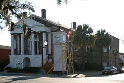
Numerous buildings and structures located in Conway are on the National Register of Historic Places. Among these is the City Hall building, designed by Robert Mills, architect of the Washington Monument. Since the completion of the Main Street USA project in the 1980s, Conway's downtown has been revitalized with shops and bistros. Highlighting the renovation of the downtown area is the Riverwalk, an area of fine dining which follows a stretch of the Waccamaw River that winds through Conway.
History
Conway is one of the oldest towns in South Carolina. Early English colonists named the village "Kings Town" but soon changed it to "Kingston". The town was founded in 1732 as part of Royal Governor Robert Johnson's Township Scheme. It was laid out on a bluff overlooking the Waccamaw River in what is now known as Horry County.
Many area residents fought in the American Revolution, and small engagements were fought near Kingston at Bear Bluff and at Black Lake. Francis Marion, who was known as the "Swamp Fox", had an encampment near Kingston just across the Waccamaw River. The areas of Kingston and Charles Town, S.C.[8] were communities with a higher population of Tories than many other Colonial American towns during the revolutionary war era. A Tory was a colonist who supported England during that period.
After the war, patriotic citizens wanted to discard the name that honored Great Britain's King George II. The county's name was changed to Horry (pronounced "oh-ree") in honor of General Peter Horry in 1801, and a courthouse was established in Kingston. "Kingston" was later changed to "Conwayborough", for General Robert Conway. In 1883, the General Assembly changed the name to "Conway".
Geography
Conway is situated on the South Carolina Coastal Plain on the western banks of the Waccamaw River, and is approximately 14 miles (23 km) from the Atlantic Ocean. U.S. Route 701 passes through the city center, leading northeast 44 miles (71 km) to Whiteville, North Carolina, and southwest 36 miles (58 km) to Georgetown. U.S. Route 501 runs through the southwest side of Conway, leading southeast 14 miles (23 km) to Myrtle Beach and northwest 33 miles (53 km) to Marion. U.S. Route 378 has its eastern terminus in Conway and leads west 46 miles (74 km) to Lake City.
According to the United States Census Bureau, the city has a total area of 22.8 square miles (59.0 km2), of which 21.9 square miles (56.8 km2) are land and 0.85 square miles (2.2 km2), or 3.69%, are water.[5] The downtown is sited on the west bank of the Waccamaw River where it is joined by a creek called Kingston Lake. The Waccamaw flows south to the Pee Dee River and ultimately Winyah Bay at Georgetown.
Demographics
| Historical population | |||
|---|---|---|---|
| Census | Pop. | %± | |
| 1860 | 476 | — | |
| 1870 | 696 | 46.2% | |
| 1880 | 575 | −17.4% | |
| 1890 | 677 | 17.7% | |
| 1900 | 705 | 4.1% | |
| 1910 | 1,228 | 74.2% | |
| 1920 | 1,969 | 60.3% | |
| 1930 | 3,011 | 52.9% | |
| 1940 | 5,066 | 68.2% | |
| 1950 | 6,073 | 19.9% | |
| 1960 | 8,563 | 41.0% | |
| 1970 | 8,151 | −4.8% | |
| 1980 | 10,240 | 25.6% | |
| 1990 | 9,819 | −4.1% | |
| 2000 | 11,788 | 20.1% | |
| 2010 | 17,103 | 45.1% | |
| Est. 2016 | 22,761 | [6] | 33.1% |
| U.S. Decennial Census[9] | |||

As of the census[3] of 2000, there were 11,788 people, 4,259 households, and 2,942 families residing in the city. The population density was 927.8 people per square mile (358.1/km²). There were 4,783 housing units at an average density of 376.5 per square mile (145.3/km²). The racial makeup of the city was 55.82% White, 41.85% African American, 0.21% Native American, 0.74% Asian, 0.03% Pacific Islander, 0.64% from other races, and 0.72% from two or more races. Hispanic or Latino of any race were 1.87% of the population.
There were 4,259 households out of which 32.8% had children under the age of 18 living with them, 42.3% were married couples living together, 23.3% had a female householder with no husband present, and 30.9% were non-families. 26.7% of all households were made up of individuals and 9.9% had someone living alone who was 65 years of age or older. The average household size was 2.52 and the average family size was 3.02.
In the city, the population was spread out with 25.1% under the age of 18, 15.8% from 18 to 24, 25.3% from 25 to 44, 20.2% from 45 to 64, and 13.6% who were 65 years of age or older. The median age was 33 years. For every 100 females, there were 83.2 males. For every 100 females age 18 and over, there were 75.0 males.
The median income for a household in the city was $32,155, and the median income for a family was $39,189. Males had a median income of $26,720 versus $21,310 for females. The per capita income for the city was $16,611. About 15.9% of families and 20.2% of the population were below the poverty line, including 32.9% of those under age 18 and 16.0% of those age 65 or over.
Government
The city is run by an elected mayor–council government system, with council members being Randle L. Alford, Ashley Smith, William Goldfinch IV, Jean M. Timbes, Thomas J. Anderson II, and Larry A. White. The current mayor is Barbara Jo Blain-Bellamy.[10]
Education
Most of the county is served by a single public school system, Horry County Schools. Private schools include Conway Christian School.
Conway is home to two major institutes of higher learning, Coastal Carolina University and Horry-Georgetown Technical College. It is also home to a branch of Webster University, an MBA graduate school, and North American Institute of Aviation (NAIA), a flight school.
Transportation
Air
Conway is home to the Conway-Horry County Airport (HYW),[11] a small airport located 4 miles (6 km) west of town, along US-378.
Bus
A large part of Horry County is served by the Coast Regional Transit Authority (RTA),[12] formerly known as the Waccamaw Regional Transit Authority and as Lymo. The primary station and offices are located in downtown Conway, near the historic district.
Railroads
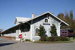
R. J. Corman Railroad's Carolina Line is a short-line railroad which serves parts of North and South Carolina. Conway is located on the railroad's Chadbourn, NC-Myrtle Beach, SC branch. The historical Conway railroad depot is located along this branch, although the depot is now an office building.
Economy
Notable companies/employers located in the Conway area include:
- New South Companies, Inc. (a subsidiary of Canfor)
- Vulcan Materials Company
- AVX Corporation
Grainger Generating Station was a coal-fired power plant operated by Santee Cooper. It generated electricity from 1966 until its retirement in 2012.[13]
Media
- Conway Journal
- Rivertown Radio
- Horry Independent
Culture
Conway is the home of Kimbel Library and the Rebecca Randall Bryan Art Gallery at Coastal Carolina University. The gallery houses differing exhibits throughout the year. Admission is free, and the gallery is open to the public.[14]
Sports
HTC Center, originally known as the Student Recreation and Convocation Center, is a 3,370-seat multi-purpose arena located on the campus of Coastal Carolina University in Conway. It is home to the university's men's and women's basketball teams, and the women's volleyball teams. It replaced Kimbel Arena for this purpose.
An arena project, known as Y2R2, intended to house the university teams and the proposed future Myrtle Beach Thunderboltz hockey team, did not gain approvals for development.
Notable people
- William Gibson, author, credited as the father of the cyberpunk genre of science fiction
- Junior Hemingway, former Michigan Wolverine wide receiver drafted in the 7th round of the 2012 NFL Draft by the Kansas City Chiefs
- Edgar L. McGowan, commissioner of South Carolina Department of Labor 1971 - 1989, born in Conway 1920 [15]
- Kristy McPherson, golfer on the LPGA Tour
- Allen Patrick, Oklahoma Sooner running back and NFL player drafted by the Baltimore Ravens in the 7th round in 2008
- Sheri Reynolds, author and associate professor of southern literature at Old Dominion University, Norfolk, Virginia
- Jesse Rice, award winning and multi-platinum Nashville songwriter of such hits as #1 country song "Cruise" by Florida Georgia Line
- Nick Shalosky, first openly gay elected official in South Carolina.
See also
- Chicora tribe, remnants of whom are centered in Conway and are seeking official recognition by the state
References
- ↑ "City of Conway, SC". City of Conway. Retrieved January 24, 2018.
- ↑ "CONWAY CITY COUNCIL". cityofconway.com. Archived from the original on 23 September 2015. Retrieved 19 August 2015.
- 1 2 "American FactFinder". United States Census Bureau. Archived from the original on 2013-09-11. Retrieved 2008-01-31.
- ↑ "US Board on Geographic Names". United States Geological Survey. 2007-10-25. Retrieved 2008-01-31.
- 1 2 "Geographic Identifiers: 2010 Census Summary File 1 (G001): Conway city, South Carolina". American Factfinder. U.S. Census Bureau. Retrieved January 24, 2018.
- 1 2 "Population and Housing Unit Estimates". Retrieved June 9, 2017.
- ↑ "Find a County". National Association of Counties. Archived from the original on 2011-05-31. Retrieved 2011-06-07.
- ↑ "Estate Confiscation Lists". sc_tories.tripod.com. Retrieved 2018-04-21.
- ↑ "Census of Population and Housing". Census.gov. Archived from the original on May 12, 2015. Retrieved June 4, 2015.
- ↑ Official Conway City Council Page Archived 2010-09-24 at the Wayback Machine.
- ↑ AirNav: KHYW - Conway-Horry County Airport
- ↑ The Coast RTA
- ↑ "Santee Cooper board authorizes retirements of Jefferies and Grainger generating units". The Summerville Journal Scene. October 19, 2012. Retrieved January 2, 2018.
- ↑ "Bryan Art Gallery". Coastal Carolina University. Retrieved January 24, 2018.
- ↑ http://accesswdun.com/article/2004/2/175888
External links
Places adjacent to Conway, South Carolina | |
|---|---|
Municipalities and communities of Horry County, South Carolina, United States | ||
|---|---|---|
| Cities | 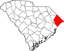 | |
| Towns | ||
| CDPs | ||
| Unincorporated communities | ||