Simpsonville, South Carolina
| Simpsonville, South Carolina | |
|---|---|
| City | |
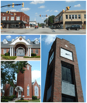 From top, left to right: Downtown, City Hall, Simpsonville Baptist Church, Simpsonville Clock Tower | |
| Motto(s): "Character Protected, Community Perfected" | |
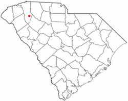 Location of Simpsonville, South Carolina | |
| Coordinates: 34°44′0″N 82°15′36″W / 34.73333°N 82.26000°WCoordinates: 34°44′0″N 82°15′36″W / 34.73333°N 82.26000°W | |
| Country | United States |
| State | South Carolina |
| County | Greenville |
| Government | |
| • Mayor | Janice Curtis |
| Area | |
| • Total | 8.83 sq mi (22.88 km2) |
| • Land | 8.81 sq mi (22.82 km2) |
| • Water | 0.02 sq mi (0.06 km2) |
| Elevation | 860 ft (262 m) |
| Population (2010) | |
| • Total | 18,238 |
| • Density | 2,070/sq mi (799.4/km2) |
| Time zone | UTC−5 (Eastern (EST)) |
| • Summer (DST) | UTC−4 (EDT) |
| ZIP codes | 29680-29681 |
| Area code(s) | 864 |
| FIPS code | 45-66580[1] |
| GNIS feature ID | 1250898[2] |
| Website |
www |
Simpsonville is a city in Greenville County, South Carolina, United States. It is part of the Greenville–Mauldin–Easley Metropolitan Statistical Area. The population was 18,238 at the 2010 census,[3] up from 14,352 in 2000. The population had risen to an estimated 20,736 as of 2015.[4] Simpsonville is part of the "Golden Strip", along with Mauldin and Fountain Inn, an area which is noted for having low unemployment due to a diversity of industries including Para-Chem, Kemet, Sealed Air and Milliken.
History
The Burdette Building, Cureton-Huff House, Hopkins Farm, and Simpsonville Baptist Church are listed on the National Register of Historic Places.[5]
Geography
Simpsonville is located in southeastern Greenville County at 34°44′0″N 82°15′36″W / 34.73333°N 82.26000°W (34.733375, -82.260001),[6] between Mauldin to the northwest and Fountain Inn to the southeast. The center of town has an elevation of 866 feet (264 m) above sea level.
South Carolina Highway 14 runs through the center of Simpsonville as Main Street, leading north 16 miles (26 km) to Greer and southeast 5 miles (8 km) to the center of Fountain Inn. The center of Mauldin is 4.5 miles (7.2 km) to the northwest via South Carolina Highway 417. Interstate 385 passes through Simpsonville west of the city center, with access from Exits 26 through 29. I-385 leads northwest 14 miles (23 km) to the center of Greenville and southeast 28 miles (45 km) to Interstate 26 near Clinton. Columbia, the state capital, is 89 miles (143 km) southeast of Simpsonville.
According to the United States Census Bureau, Simpsonville has a total area of 8.83 square miles (22.88 km2), of which 8.81 square miles (22.82 km2) are land and 0.02 square miles (0.06 km2), or 0.28%, are water.[3]
Demographics
| Historical population | |||
|---|---|---|---|
| Census | Pop. | %± | |
| 1900 | 195 | — | |
| 1910 | 521 | 167.2% | |
| 1920 | 566 | 8.6% | |
| 1930 | 1,400 | 147.3% | |
| 1940 | 1,298 | −7.3% | |
| 1950 | 1,529 | 17.8% | |
| 1960 | 2,282 | 49.2% | |
| 1970 | 3,308 | 45.0% | |
| 1980 | 9,037 | 173.2% | |
| 1990 | 11,708 | 29.6% | |
| 2000 | 14,352 | 22.6% | |
| 2010 | 18,238 | 27.1% | |
| Est. 2016 | 21,314 | [7] | 16.9% |
| U.S. Decennial Census[8] | |||
As of the census[1] of 2010, there were 18,238 people and 7,040 households. The population density was 2,070.1 people per square mile (799.4 per km2). There were 7,624 housing units at an average density of 865.4 per square mile (334.1 per km2). The racial makeup of the city was 75.7% White, 16.4% African American, 0.3% Native American, 1.3% Asian, 0.1% Pacific Islander, and 2.3% from two or more races. Hispanic or Latino of any race were 8.9% of the population. 26.0% of the population was under 18, and 11.0% of the population was over 65. 51.6% of the population was female.[9]
For the period 2011-2015, the estimated median annual income for a household in the city was $56,691, and the per capita income was $28,537. 7.3% of the population were below the poverty line.[10]
Crime
While Simpsonville's crime statistics are higher than national average crime rates, they are drastically lower than major U.S. cities. Violent crimes in 2010 totalled 82 for the year.[11] 2006 statistics of violent crime in Simpsonville reflect there was not one murder, reported incidents of rape were slightly higher than the national average(39 per 100,000 in Simpsonville, with a national average of 33 per 100,000), and incidents of aggravated assaults were what tipped the 2006 violent crime scales, tallying in at 75% over the national average. In 2007 the personal crime incidents rate tallied in at 6 per 1000 residents, while the national average was 1.3 per 1000.[12] In September 2007, the FBI reported that the state of South Carolina's violent crime rate was the highest in the nation per capita, although Simpsonville is not mentioned at all in the article.[13] Car theft in Simpsonville was lower than the national average, causing unsubstantiated claims that Simpsonville allegedly has a high rate of car-jackings to be discredited.
Government
Simpsonville is governed by a mayor, a city council, and several boards and commissions. The current officeholders are:
- Mayor: Janice Curtis (1st term ends 12-31-2019)
- Council Ward I: Matthew Gooch (2nd term ends 12-31-2019)
- Council Ward II: Stephanie Kelley (1st term ends 12-31-2021)
- Council Ward III: Jenn Hulehan (1st term ends 12-31-2019)
- Council Ward IV: Sherry Roche (1st term ends 12-31-2021)
- Council Ward V: Ken Cummings (1st term ends 12-31-2019)
- Council Ward VI: Lou Hutchings (1st term ends 12-31-2021)
- City Administrator: Vacant, following the death of City Administrator Eddie Case. Dianna Gracely, currently the City Administrator of nearby Travelers Rest, will fill the position effective March 1, 2018.
Education and activities
Simpsonville is home to Hillcrest High School. The city was home to the 2008 Little League Softball World Champions.
Abiding Peace Academy is a K2-5 grade school of the Wisconsin Evangelical Lutheran Synod in Simpsonville.[14]
Notable people
- Justin Bolli, professional golfer
- Danielle Brooks, actress, stars in Orange Is the New Black and was Tony Award-nominated for role as Sofia on Broadway in The Color Purple.
- Chandler Catanzaro, placekicker for NFL's New York Jets
- Danelle German, creator of cat handbags and founder of National Cat Groomers Institute of America
- Lucas Glover, PGA Tour golfer, winner of 2009 U.S. Open Golf Championship
- Shane Hall, NASCAR driver
- Tommy Jones, professional bowler; 2005-06 PBA Player of the Year
- Jamon Meredith, offensive tackle, 2009 fifth-round draft pick of NFL's Green Bay Packers
- Travelle Wharton, offensive tackle for NFL's Carolina Panthers
- Stephen Thompson , UFC fighter
- Emilio Pagan, pitcher for MLB's Oakland A's
- Sam Tam, Musician, world-class pianist, singer, professional time-waster
References
- 1 2 "American FactFinder". United States Census Bureau. Retrieved 2008-01-31.
- ↑ "US Board on Geographic Names". United States Geological Survey. 2007-10-25. Retrieved 2008-01-31.
- 1 2 "Geographic Identifiers: 2010 Demographic Profile Data (G001): Simpsonville city, South Carolina". American Factfinder. U.S. Census Bureau. Retrieved February 10, 2017.
- ↑ "QuickFacts: Simpsonville city, South Carolina". U.S. Census Bureau. Retrieved February 10, 2017.
- ↑ National Park Service (2010-07-09). "National Register Information System". National Register of Historic Places. National Park Service.
- ↑ "US Gazetteer files: 2010, 2000, and 1990". United States Census Bureau. 2011-02-12. Retrieved 2011-04-23.
- ↑ "Population and Housing Unit Estimates". Retrieved June 9, 2017.
- ↑ "Census of Population and Housing". Census.gov. Retrieved June 4, 2015.
- ↑ "Profile of General Population and Housing Characteristics: 2010 Census Summary File 1 (DP-1): Simpsonville city, South Carolina". American Factfinder. U.S. Census Bureau. Retrieved February 10, 2017.
- ↑ "Selected Economic Characteristics: 2011-2015 American Community Survey 5-Year Estimates (DP03): Simpsonville city, South Carolina". American Factfinder. U.S. Census Bureau. Retrieved February 10, 2017.
- ↑ "FBI Uniform Crime Reports". Retrieved 23 March 2014.
- ↑ MONEY Magazine: Best places to live 2007: Simpsonville, SC snapshot
- ↑ S.C.'s violent crime rate again highest in nation | Spartanburg, South Carolina | GoUpstate.com, Spartanburg Herald-Journal
- ↑ "Our School".
External links
| Wikimedia Commons has media related to Simpsonville, South Carolina. |
| Wikivoyage has a travel guide for Simpsonville. |
Municipalities and communities of Greenville County, South Carolina, United States | ||
|---|---|---|
| Cities | 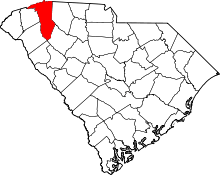 | |
| CDPs | ||
| Unincorporated communities | ||
| Footnotes | ‡This populated place also has portions in an adjacent county or counties | |
Columbia (capital) | ||
| Regions | ||
| Larger cities | ||
| Smaller cities |
| |
| Towns |
| |
| CDPs | ||
| Counties |
| |
| Topics |
| |
| Society | ||