Koval'sky (crater)
 THEMIS image of Koval'sky | |
| Planet | Mars |
|---|---|
| Region | Memnonia quadrangle |
| Coordinates | 29°34′S 142°32′W / 29.56°S 142.54°WCoordinates: 29°34′S 142°32′W / 29.56°S 142.54°W |
| Diameter | 296.67 km |
| Eponym | Marian Kowalski |
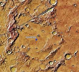
Koval'sky is a small impact crater on Mars, located in the southernmost area of the Memnonia quadrangle at 29.56° south and longitude 142.54° west. It measures approximately 297 kilometers in diameter. The crater's southern portion is located in the Phaethontis quadrangle, in the southwestern part of Mars. Its was named after Polish–Russian astronomer Marian Kowalski (1821–1884). The name was adopted by IAU's Working Group for Planetary System Nomenclature in 1985.[1]
Nearby named craters include Pickering to the east-southeast, Bernard to the west-northwest and the tiny Zumba to the east, that is inside Phoenicis quadrangle.
The crater are in between two smaller rilles that were once fault lines, the northwestern part is called Sirenum Fossae. Parts of the crater were covered by lava flows from Arsia Mons. and the area to the northeast.[2] In that location with a few craters predominantly small is the Daedalia Planum.
The crater is not circular at all due to the lava flows in the past. The southern portion south of the small crater and the hills forms no part of Koval'sky, but the southwestern portion that was once a separate crater forms a part of Koval'sky.
See also
References
- ↑ "Gazetteer of Planetary Nomenclature | Koval'sky". usgs.gov. International Astronomical Union. Retrieved 20 August 2017.
- ↑ NASA SP-441: VIKING ORBITER VIEWS OF MARS, Viking Orbiter Imaging Team, 1980, chapter 5 (Volcanic Features)
External links
- NASA Astronomy Picture of the Day: Odyssey over Mars (22 March 2002) - includes a part of Terra Sirenum that was above the crater Koval'sky