Huggins (Martian crater)
 Topographic location of Huggins Crater. The map is partly oval due to the mapping marked at the equator which makes features north or south of it oval | |
| Planet | Mars |
|---|---|
| Region | Eridania quadrangle |
| Coordinates | 49°24′S 150°36′E / 49.4°S 150.6°ECoordinates: 49°24′S 150°36′E / 49.4°S 150.6°E |
| Diameter | 90 km |
| Eponym | William Huggins |
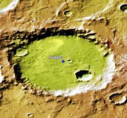
Huggins is an impact crater in the Eridania quadrangle of Mars, located at 49.4°S latitude and 204.4°W longitude, and is part of Terra Cimmeria. It is 90.0 km in diameter and was named after William Huggins, and the name was approved in 1973 by the International Astronomical Union (IAU) Working Group for Planetary System Nomenclature (WGPSN).[1]

Huggins Crater, as seen by CTX camera (on Mars Reconnaissance Orbiter).
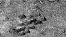
Dunes and dust devil tracks on floor of Huggins Crater, as seen by CTX camera (on Mars Reconnaissance Orbiter). Dark streaks on dunes are dust devil tracks. Note: this is an enlargement of the previous image of Huggins Crater.
Nearby named craters include Cruls to the northeast, Rossby almost to the east, Campbell to the southeast, and the small Tycho Brahe to the west and the larger Kepler. West of Huggins is a feature known as Eridania Scopulus.
See also
References
- ↑ "Gazetteer of Planetary Nomenclature | Huggins". usgs.gov. International Astronomical Union. Retrieved 4 March 2015.
This article is issued from
Wikipedia.
The text is licensed under Creative Commons - Attribution - Sharealike.
Additional terms may apply for the media files.