Brooklyn Bridge–City Hall/Chambers Street (New York City Subway)
Brooklyn Bridge–City Hall/ Chambers Street | |||||||||||
|---|---|---|---|---|---|---|---|---|---|---|---|
|
| |||||||||||
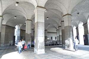 Municipal Building entrance | |||||||||||
| Station statistics | |||||||||||
| Borough | Manhattan | ||||||||||
| Locale | Civic Center | ||||||||||
| Coordinates | 40°42′46″N 74°0′17″W / 40.71278°N 74.00472°WCoordinates: 40°42′46″N 74°0′17″W / 40.71278°N 74.00472°W | ||||||||||
| Division | A (IRT), B (BMT) | ||||||||||
| Line |
IRT Lexington Avenue Line BMT Nassau Street Line | ||||||||||
| Services |
4 5 6 J Z | ||||||||||
| Transit connections |
| ||||||||||
| Structure | Underground | ||||||||||
| Other information | |||||||||||
| Opened | 1914 | ||||||||||
| Station code | 622[1] | ||||||||||
| Accessible |
| ||||||||||
| Wireless service |
| ||||||||||
| Traffic | |||||||||||
| Passengers (2017) |
9,360,484 (station complex)[3] | ||||||||||
| Rank | 31 out of 425 | ||||||||||
| |||||||||||
| |||||||||||
| |||||||||||


Brooklyn Bridge–City Hall/Chambers Street is a New York City Subway station complex in Lower Manhattan. The complex is served by trains of the IRT Lexington Avenue Line and the BMT Nassau Street Line. The following services stop at this station:
Station layout
| G | Street Level | Exit/ Entrance |
| M | Mezzanine | Fare control, station agents |
| P Nassau Street Line Platform |
Side platform, not in service | |
| Northbound | ← | |
| Island platform, doors will open on the left | ||
| Northbound boarding | ← No regular service | |
| Island platform, not in service | ||
| Southbound termination | → No regular service | |
| Island platform, doors will open on the left | ||
| Southbound through | → | |
| Side platform, not in service, mostly demolished | ||
| P Lexington Avenue Line Platform |
Side platform, not in service | |
| Northbound local | ← ← | |
| Island platform, doors will open on the left, right | ||
| Northbound express | ← ← | |
| Southbound express | → → | |
| Island platform, doors will open on the left, right | ||
| Southbound local | → (No service: City Hall) | |
| Side platform, not in service | ||
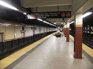
BMT Nassau Street Line platforms
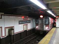
Chambers Street | |||||||||||
|---|---|---|---|---|---|---|---|---|---|---|---|
|
| |||||||||||
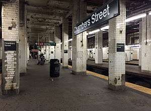 Northbound platform. On the right is the unused middle platform and downtown platform. | |||||||||||
| Station statistics | |||||||||||
| Division | B (BMT) | ||||||||||
| Line | BMT Nassau Street Line | ||||||||||
| Services |
J Z | ||||||||||
| Structure | Underground | ||||||||||
| Platforms | 3 island platforms (2 active), 2 side platforms (1 demolished; 1 disused) | ||||||||||
| Tracks | 4 (2 in regular service) | ||||||||||
| Other information | |||||||||||
| Opened | August 4, 1913[4] | ||||||||||
| Station code | 105[1] | ||||||||||
| Accessible |
| ||||||||||
| Wireless service |
| ||||||||||
| Station succession | |||||||||||
| Next north |
Canal Street: J | ||||||||||
| Next south |
Fulton Street: J | ||||||||||
| |||||||||||
|
| |||||||||||
|
Chambers Street Subway Station (Dual System BMT) | |||||||||||
| MPS | New York City Subway System MPS | ||||||||||
| NRHP reference # | 05000669[5] | ||||||||||
| Added to NRHP | July 6, 2005 | ||||||||||
Chambers Street on the BMT Nassau Street Line is located at the intersection of Centre and Chambers Streets beneath the Manhattan Municipal Building. The station has four tracks, three island platforms, and one side platform (originally two).
The southbound platform is slightly higher at the southern end of the station because the next stop south, Fulton Street, is bi-level with the southbound platform being above the northern one. The two "express" tracks, currently unused in regular revenue service, merge into a single tail track south of the station. The tail track is 620 feet (190 m) long from the switch points to the bumper block, where an emergency exit is available. The tail track south of the station was the site of an M train crash on November 6, 2007.[6]
North of this station, there are two stub tracks, which end behind the now-closed Queens-bound side platform.[7][8] These tracks were formerly connected to the Manhattan Bridge, until they were disconnected in 1967 as part of the Chrystie Street Connection, with the BMT Broadway Line being connected to the bridge instead. Also north of this station, the former southbound express track (now the northbound track) splits into two tracks just south of Canal Street: the former northbound local track, and the former southbound express track (the current northbound track).
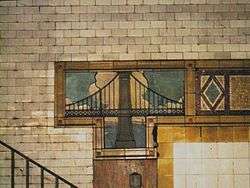
The tile work on this station includes a depiction of the nearby Brooklyn Bridge that has a subtle mistake: it features the parallel up-down cables between the main cable and the roadway (as seen alone on most suspension bridges) but misses the second set of diagonal cables that radiate from the bridge to the roadway (as seen on cable-stayed bridges).
Exits
The BMT station has two main exits/entrances, both of which are shared with the IRT station via a passageway:
- Stair on south edge of Foley Square[9]
- Stair under Manhattan Municipal Building just southeast of the intersection of Centre and Chambers Streets[9]
History
When it was being built before World War I, Chambers Street was designed to be the BMT's Manhattan hub, with trains arriving from Brooklyn in both directions, and terminating here. It was envisioned as a City Hall terminal, a kind of downtown Grand Central Terminal at a time when the business and population center of the city was still closer to the southern end of the island. Three years after the Chambers Street station opened, its four wide platforms were so overcrowded that one newspaper article described them as "more dangerous during the rush hours than at the Grand Central or the Fourteenth Street Stations."[10]
Originally, trains arrived from the north via either the Williamsburg Bridge or the Manhattan Bridge; the connection to the Montague Street Tunnel had not yet been completed. The loop configuration permitted trains arriving in either direction from the BMT Fourth Avenue Line in Brooklyn to pass through Chambers Street and return to Fourth Avenue without having to reverse direction. The BMT Brooklyn Loops, a track connection to the Brooklyn Bridge that would have connected to the Williamsburg Bridge tracks, was planned in the station's design, but was only partially built. The finished portions of the tunnel to the Brooklyn Bridge led directly to wine vaults under the bridge.[11]
By the mid-1920s, the subway itself was pushing the city's population north and leaving Chambers Street behind. The Nassau Street Loop was completed in 1931, making Chambers Street a through station south to the Montague Street Tunnel to Brooklyn. At this point, the center island platform and the two side platforms were closed. By the 1950s, many of the city's business interests had shifted to Midtown. The west side platform was walled up and most of it was destroyed when Brooklyn Bridge–City Hall on the IRT Lexington Avenue Line was rebuilt on the other side of the wall in 1960–62. The Chrystie Street Connection, completed in 1967, severed the Nassau line's connection to the Manhattan Bridge, so that the bridge tracks could connect instead to the uptown IND Sixth Avenue Line. The tracks heading towards the Manhattan Bridge (now used for train storage) are visible from northbound trains leaving Chambers Street.
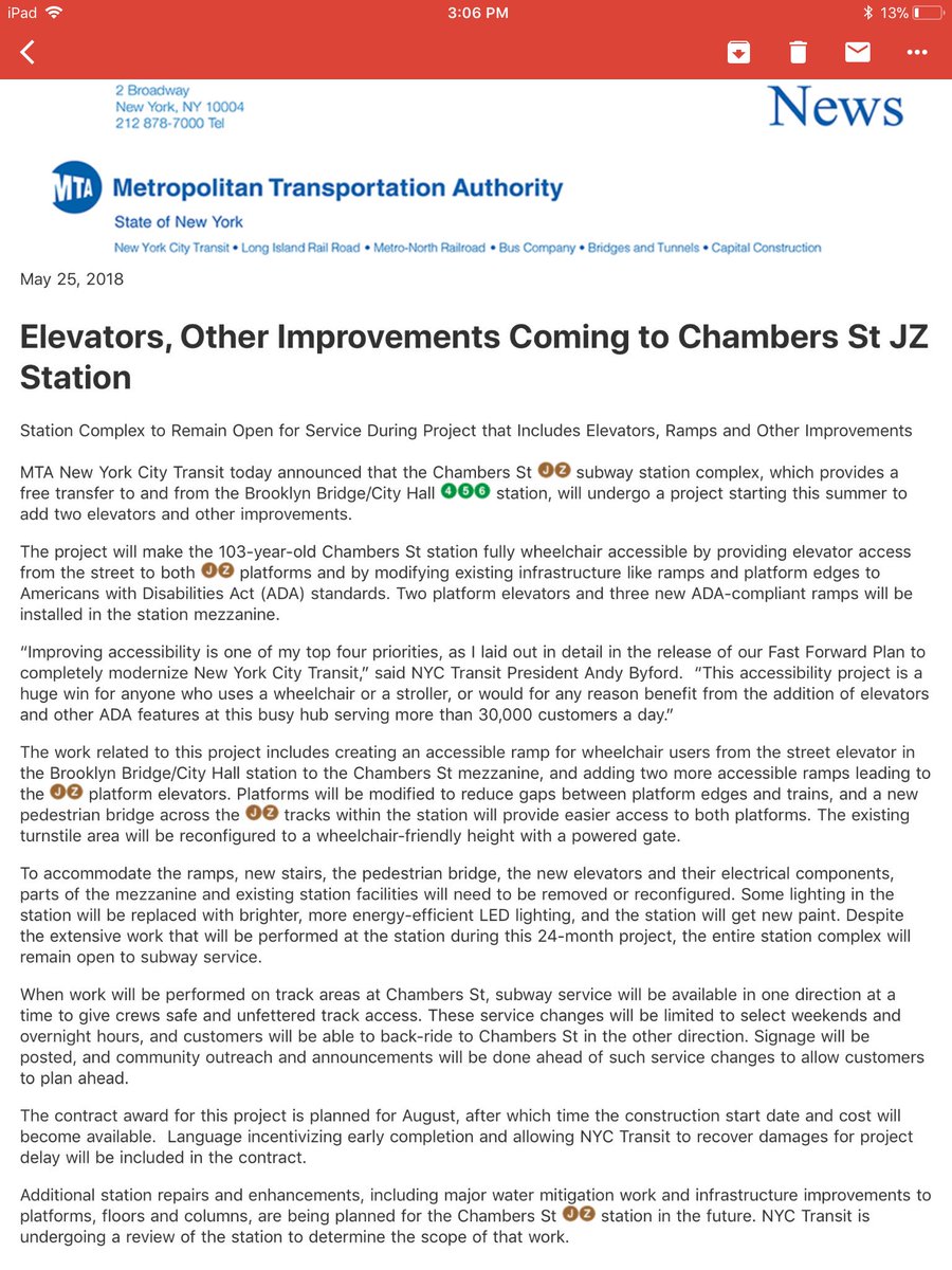
Although altered over the years to account for changing ridership patterns, the station has not been renovated. In a 2003 poll, it was voted the ugliest station in the system.[10] In May 2018, it was announced that the MTA would start renovating the Chambers Street station that August. The station will receive two platform elevators and three new ramps in the mezzanine. One ramp will allow passengers using the Chambers Street mezzanine to use the street elevator in the Brooklyn Bridge–City Hall station. The two other ramps will lead to the two platform elevators. The station platforms will be modified to reduce the gap between trains and the platform edges, and a pedestrian bridge will be installed above the tracks, connecting both of the open platforms. To accommodate the ramps, elevators, and pedestrian bridge, portions of the station and mezzanine will need to be removed or reconfigured. These improvements will make the station compliant with the Americans with Disabilities Act of 1990,[12] and are being funded as part of the 2015–2019 MTA Capital Program.[13][14][15][16] The project will take at least 24 months to be completed.[17]
In popular culture
- Subway scenes from the 1956 film Somebody Up There Likes Me were filmed at the Chambers Street station.
- The station was used to film a scene in the 1980 film Fame.
- In the 1986 film Crocodile Dundee, muggers inside the Municipal Building entrance to the station pull a knife on the title character (Paul Hogan) and his girlfriend Sue (Linda Kozlowski); Dundee responds by saying of the muggers' knife, "That's not a knife." Pulling a larger knife of his own, he then says, "That's a knife."[18]
- The station was used in the 1998 adaptation of Great Expectations, in a climactic scene featuring Ethan Hawke and Robert De Niro.
- The station was also briefly featured in the short film/music video "Hurricane" by Thirty Seconds to Mars.
- The corridor connecting the two stations was used for a scene in the TV show Person of Interest.
- The Foley Square entrance staircase has been a popular filming location for numerous New York based TV shows, specifically Law & Order and Flight of the Conchords.
Image gallery
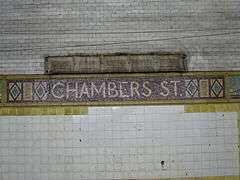 Name of station in mosaics
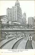 Early postcard depiction of station
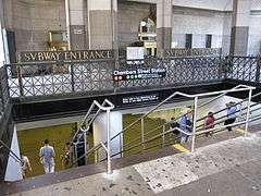 Renovated Municipal Building entrance
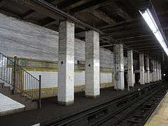 Disused northbound side platform
 Northbound platform used by J train
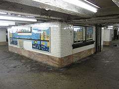 Former ticket booths at Chambers Street
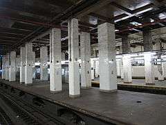 Disused center platform
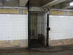 Abandoned women's restroom
IRT Lexington Avenue Line platforms
Brooklyn Bridge–City Hall | |||||||||||
|---|---|---|---|---|---|---|---|---|---|---|---|
|
| |||||||||||
 Uptown island platform | |||||||||||
| Station statistics | |||||||||||
| Address |
Park Row & Centre Street New York, NY 10007 | ||||||||||
| Division | A (IRT) | ||||||||||
| Line | IRT Lexington Avenue Line | ||||||||||
| Services |
4 5 6 | ||||||||||
| Structure | Underground | ||||||||||
| Platforms |
2 island platforms (in service) cross-platform interchange 2 side platforms (abandoned) | ||||||||||
| Tracks | 4 | ||||||||||
| Other information | |||||||||||
| Opened | October 27, 1904[19] | ||||||||||
| Station code | 411[1] | ||||||||||
| Accessible |
| ||||||||||
| Wireless service |
| ||||||||||
| Former/other names |
Brooklyn Bridge Brooklyn Bridge–Worth Street Chambers Street | ||||||||||
| Station succession | |||||||||||
| Next north |
14th Street–Union Square (express): 4 Canal Street (local): 4 Worth Street (local; closed): no service | ||||||||||
| Next south |
(Terminal): 6 City Hall (local; closed): no passenger service Fulton Street: 4 | ||||||||||
|
| |||||||||||
| Next |
Grand Central–42nd Street (express): 4 Canal Street (local): 4 | ||||||||||
| Next |
none: 6 Fulton Street: 4 | ||||||||||
| |||||||||||
|
| |||||||||||
|
Brooklyn Bridge-City Hall Subway Station (IRT) | |||||||||||
| MPS | New York City Subway System MPS | ||||||||||
| NRHP reference # | 05000674[5] | ||||||||||
| Added to NRHP | July 6, 2005 | ||||||||||
Brooklyn Bridge–City Hall is an express station on the IRT Lexington Avenue Line which is located on Park Row at the Manhattan end of the Brooklyn Bridge. This is the southern terminal for the 6 train, which turns via the City Hall Loop to head back uptown.
Just north of the station are crossovers that allow trains to switch between the local and express tracks, which allow Lexington Avenue local trains to continue south via the express tracks if necessary (rather than using the City Hall loop). Due to the closure of City Hall station in 1945, Brooklyn Bridge–City Hall (which had simply been Brooklyn Bridge) became the southernmost station on normal Lexington Avenue local service.
South of the station, the downtown local track splits into three tracks. The westernmost track loops around to the northbound local track through City Hall station. The other two are layup tracks parallel to the downtown express track. Until 1963, they merged into the downtown express track north of Fulton Street, but now they end at bumper blocks a little north of Fulton Street, and are occasionally used for train storage.[20]
The station has been renovated, with new tile and ADA-accessible elevator access. It is the zero point for the IRT East Side chain; mile 0 is at the south end of the station.
The Brooklyn Bridge station has a number of closed off areas as construction and service patterns have required changes to be made to the station. In addition to the two island platforms, there are two short side platforms on the outer edges of the station. Like those on the IRT Lexington Avenue Line at 14th Street–Union Square and on the IRT Broadway–Seventh Avenue Line at 96th Street, these side platforms were built to accommodate extra passenger volume and were built to the five-car length of the original IRT local trains. These platforms did not see much use as they were located at express stations, which allow cross-platform interchanges via the island platforms. When trains were lengthened to their current ten-car length, it was impractical to lengthen both these side platforms and the island platforms. They were closed in 1910 after only six years in operation and walled off along the platform edges.
The side platform on the southbound side is now home to some electrical equipment and a backup control tower for the Brooklyn Bridge interlocking, just north of the station. The tower is functional but not normally used, because the Grand Central–42nd Street tower is the primary control point for the whole line. The interlocking board can be seen through a window along the wall along the southbound local trackway. The south end of the downtown side platform is still visible near the dispatcher's booth on the downtown island platform.
There are also some closed portions at the south ends of the existing express platforms that feature gap fillers and original mosaic tiles. During the station lengthening projects, it was deemed easier to lengthen the express platform northward, as the curves at the south end proved impossible to rework. The lengthening resulted in the closure of Worth Street, the closure of the curved southern ends of the express platforms, and the demolition of the western side platform at Chambers Street on the BMT Nassau Line.
Artwork includes a 1996 work by Mark Gibian titled Cable Crossing.
After Worth Street station closed, the Brooklyn Bridge–City Hall station was known as Brooklyn Bridge–Worth Street. The name was reverted to Brooklyn Bridge–City Hall in 1995.
Exits
All of the IRT station's exits are shared with the BMT station via a passageway. This includes the elevator, even though the BMT platforms do not have elevators.
- Two stairs to northwest corner of Reade and Centre Streets[9]

A long passageway at the south end of the station leads to:
- One stair to a plaza just south of the Manhattan Municipal Building. This exit is smaller and faces the large BMT entrance under the building.[9]
- One stair to the Brooklyn Bridge walkway itself[9]
- Two stairs to the south side of Frankfort Street at Pace Plaza, in front of Pace University[9]
Image gallery
 Downtown Local 6 train arriving
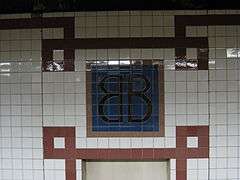 Tiles
Tiles Replica of an original IRT subway entrance kiosk (really an elevator)
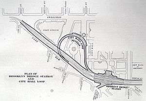 Plan of the station (lower-right corner)
References
- 1 2 3 "Station Developers' Information". Metropolitan Transportation Authority. Retrieved June 13, 2017.
- 1 2 3 "NYC Subway Wireless – Active Stations". Transit Wireless Wifi. Retrieved May 18, 2016.
- ↑ "Facts and Figures: Annual Subway Ridership 2012–2017". Metropolitan Transportation Authority. July 12, 2018. Retrieved July 12, 2018.
- ↑ New York Times, Passenger Killed on Loop's First Day, August 5, 1913, page 2
- 1 2 "NPS Focus". National Register of Historic Places. National Park Service. Retrieved December 23, 2011.
- ↑ Metropolitan Transportation Authority, M Train Incident at Chambers Street, November 6, 2007
- ↑ https://www.youtube.com/watch?v=V69X72HAZ1g The provisions for 2 tracks are clearly visible towards the right at the 3:11 mark, just after the train leaves the Chambers Street station.
- ↑ http://ltvsquad.com/2005/07/04/marginalized/
- 1 2 3 4 5 6 7 "MTA Neighborhood Maps: Lower Manhattan" (PDF). mta.info. Metropolitan Transportation Authority. 2015. Retrieved August 16, 2016.
- 1 2 Kennedy, Randy (May 13, 2003). "TUNNEL VISION; They're Subway Experts. Take Their Word on What's Ugly". New York Times. New York. Retrieved April 21, 2015.
But eventually they came to settle on the Chambers Street station beneath the Municipal Building as the clear winner in their 2003 subway station ugly contest.
- ↑ https://untappedcities.com/2018/05/24/inside-the-champagne-vaults-of-the-brooklyn-bridge-on-the-135th-anniversary-photos/
- ↑ "MTA overhauling 'forgotten' subway station after Post report". New York Post. 2018-05-25. Retrieved 2018-05-28.
- ↑ "MTA Capital Program 2015–2019: Renew. Enhance. Expand" (PDF). Metropolitan Transportation Authority. October 28, 2015. p. 61. Retrieved October 28, 2015.
- ↑ "The MTA's Key Station Plan for subway accessibility – The Weekly Nabe". The Weekly Nabe. June 13, 2013.
- ↑ "MTA 2017 Preliminary Budget July Financial Plan 2017 –2020 Volume 2" (PDF). mta.info. Metropolitan Transportation Authority. July 2016. Retrieved August 6, 2016.
- ↑ "Funding For Subway Station ADA-Accessibility Approved". www.mta.info. April 26, 2018. Retrieved April 27, 2018.
- ↑ "Elevators, Other Improvements Coming to Chambers Street JZ Station". Twitter. Metropolitan Transportation Authority. May 25, 2018. Retrieved May 28, 2018.
- ↑ Chuck Katz, Manhattan on Film: Walking Tours of Hollywood's Fabled Front Lot (Limelight, 1995), pp. 298–99.
- ↑ New York Times, Our Subway Open: 150,000 Try It, October 28, 1904
- ↑ "IRT Lexington Ave. Trackage To Be Changed". The New York Division Bulletin. Electric Railroaders' Association. 6 (3): 6. June 1963 – via Issue.
Further reading
- Stokey, Lee (1994). Subway Ceramics: A History and Iconography. ISBN 978-0-9635486-1-0.
External links
| Wikimedia Commons has media related to Brooklyn Bridge – City Hall / Chambers Street (New York City Subway). |
- nycsubway.org – BMT Nassau Street/Jamaica Line: Chambers Street
- nycsubway.org – IRT East Side Line: Brooklyn Bridge/City Hall
- Station Reporter—Brooklyn Bridge/Chambers Street Complex
- MTA's Arts For Transit—Brooklyn Bridge–City Hall/Chambers Street
- Forgotten NY—The Original 28 Subway Stations
Google Maps: Street View:
- Entrance near City Hall Park from Google Maps Street View
- Entrance north of Brooklyn Bridge from Google Maps Street View
- Entrance south of Brooklyn Bridge from Google Maps Street View
- Reade Street and Centre Street entrance from Google Maps Street View
- Foley Square entrance from Google Maps Street View
- Centre Street entrance from Google Maps Street View
- IRT platforms from Google Maps Street View
- BMT platforms from Google Maps Street View
- BMT mezzanine from Google Maps Street View
Abandoned Stations:
| Lexington Ave. Line |
|
|---|---|
| Nassau St. Line | |
| |
| Topics |   | |
|---|---|---|
| Lists by county |
| |
| Lists by city | ||
| Other lists | ||
| ||