Flushing Avenue (BMT Jamaica Line)
Flushing Avenue | |||||||||
|---|---|---|---|---|---|---|---|---|---|
|
| |||||||||
 | |||||||||
| Station statistics | |||||||||
| Address |
Flushing Avenue & Broadway Brooklyn, NY 11206 | ||||||||
| Borough | Brooklyn | ||||||||
| Locale | Williamsburg, Bedford-Stuyvesant, Bushwick | ||||||||
| Coordinates | 40°42′02″N 73°56′31″W / 40.700683°N 73.941979°WCoordinates: 40°42′02″N 73°56′31″W / 40.700683°N 73.941979°W | ||||||||
| Division | B (BMT) | ||||||||
| Line | BMT Jamaica Line | ||||||||
| Services |
J M | ||||||||
| Transit connections |
| ||||||||
| Structure | Elevated | ||||||||
| Platforms | 2 side platforms | ||||||||
| Tracks | 3 | ||||||||
| Other information | |||||||||
| Opened | June 25, 1888[1] | ||||||||
| Station code | 098[2] | ||||||||
| Accessible |
| ||||||||
| Traffic | |||||||||
| Passengers (2017) |
2,764,583[3] | ||||||||
| Rank | 189 out of 425 | ||||||||
| Station succession | |||||||||
| Next east |
Myrtle Avenue: J Park Avenue: no service; demolished | ||||||||
| Next west |
Lorimer Street: J | ||||||||
|
| |||||||||
| Next |
Sutphin Boulevard: J Myrtle-Wyckoff Avenues: M | ||||||||
| Next |
Marcy Avenue: J | ||||||||
| |||||||||
| |||||||||
| |||||||||


Flushing Avenue is a local station on the BMT Jamaica Line of the New York City Subway. Located at the intersection of Flushing Avenue and Broadway in Brooklyn, it is served by the J train at all times except weekdays in the peak direction and the M train at all times except late nights. The Z train skips this station when it operates.
History
The Union Elevated Railroad, leased to the Brooklyn Elevated Railroad, opened an elevated line above Broadway from Gates Avenue northwest to Driggs Avenue in Williamsburg on June 25, 1888. As part of the new line, the Flushing Avenue station was opened.[4] This was a branch of the existing Lexington Avenue Elevated, which then ended at Van Siclen Avenue; Broadway trains ran between Driggs and Van Siclen Avenues.[5]
Station layout
| P Platform level |
Side platform, doors will open on the right | |
| Westbound local[6] | ← ← | |
| Peak-direction express | ← | |
| Eastbound local[6] | → → | |
| Side platform, doors will open on the right | ||
| M | Mezzanine | Fare control, station agent |
| G | Street Level | Exit / Entrance |

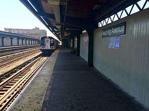
This elevated station has two side platforms and three tracks. The center track is used by the J and Z trains in the peak direction weekday midday and rush hours. Both platforms have beige windscreens with red canopies supported by green frames and support columns along the entire length. The station signs are in the standard black plate with white lettering.
The 2006 artwork here is called Migration by Robin Holder. It features stained glass windows on the platform windscreens and station house.
Exits
There are two sets of entrance/exits at the station. One is located at an elevated station house beneath the tracks, which has two staircases from either southern corners of Flushing Avenue and Broadway, token booth, turnstile bank, a waiting area that allows a free transfer between directions, and a single staircase to each platform at their extreme north end. Each staircase landing has an exit-only turnstile to allow passengers to exit the station without having to go through the station house.[7] Three elevators were installed in Fall 2003 to make this station ADA accessible due to its proximity to Woodhull Hospital. One of them is at the southwest corner of Broadway and Flushing Avenue and goes up to the adjacent staircase balcony. The other two go up to the platforms from the staircase landing.[8]
The other set of entrance/exit are stairs located at the south ends of each platform. These stairs lead to Fayette Street. There was formerly another station house at this end, but it was removed. These stairs were closed in the 1980s due to high crime,[9][10][11] but were reopened in July 2017 to address potential capacity constraints from shuttle bus transfers due to reconstruction on the Myrtle Avenue Line and the 14th Street Tunnel.[12][13]
References
- ↑ "The Broadway Line Opened". Brooklyn Daily Eagle. Brooklyn, NY. June 25, 1888. p. 6.
- ↑ "Station Developers' Information". Metropolitan Transportation Authority. Retrieved June 13, 2017.
- ↑ "Facts and Figures: Annual Subway Ridership 2012–2017". Metropolitan Transportation Authority. July 12, 2018. Retrieved July 12, 2018.
- ↑ "The Broadway Line Opened". Brooklyn Daily Eagle. Brooklyn, NY. June 25, 1888. p. 6. Retrieved February 18, 2018.
- ↑ "Trains Running This Morning". Brooklyn Daily Eagle. Brooklyn, NY. May 30, 1893. p. 10. Retrieved February 18, 2018.
- 1 2 This is a wrong-way concurrency in railroad direction.
- ↑ "MTA Neighborhood Maps: Williamsburg & Bedford-Stuyvesant" (PDF). Metropolitan Transportation Authority. 2015. Retrieved July 3, 2015.
- ↑ "Accessible Stations in the MTA Network". web.mta.info. Metropolitan Transportation Authority. Retrieved November 29, 2016.
- ↑ Harshbarger, Rebecca; De La Hoz, Felipe (October 12, 2015). "Williamsburg, Bushwick subway entrances sealed despite ridership spike". AM New York. Retrieved July 4, 2016.
- ↑ Hinds, KAte; Palazzolo, Alan (November 10, 2015). "No Exit: What Closed Subway Entrances Have to Do with Delays and Crowding". WNYC (AM). Retrieved July 4, 2016.
- ↑ "Closed subway entrances". WNYC (AM). October 31, 2015. Retrieved July 4, 2016.
- ↑ "Archived copy". Archived from the original on July 22, 2017. Retrieved August 13, 2017.
- ↑ http://secondavenuesagas.com/2017/12/13/first-look-dot-mta-ready-plans-l-train-shutdown/
External links
| Wikimedia Commons has media related to Flushing Avenue (BMT Jamaica Line). |
- nycsubway.org – BMT Jamaica Line: Flushing Avenue
- Station Reporter — J Train
- Station Reporter — M Train
- The Subway Nut — Flushing Avenue Pictures
- MTA's Arts For Transit — Flushing Avenue (BMT Jamaica Line)
- Flushing Avenue entrance from Google Maps Street View
- Platforms from Google Maps Street View
| Jamaica Line |
|
|---|---|
| |