Parkchester (IRT Pelham Line)
Parkchester | |||||||||||
|---|---|---|---|---|---|---|---|---|---|---|---|
|
| |||||||||||
_by_David_Shankbone.jpg) | |||||||||||
| Station statistics | |||||||||||
| Address |
Hugh J. Grant Circle Bronx, NY 10472 | ||||||||||
| Borough | The Bronx | ||||||||||
| Locale | Parkchester | ||||||||||
| Coordinates | 40°50′0″N 73°51′39.5″W / 40.83333°N 73.860972°WCoordinates: 40°50′0″N 73°51′39.5″W / 40.83333°N 73.860972°W | ||||||||||
| Division | A (IRT) | ||||||||||
| Line | IRT Pelham Line | ||||||||||
| Services |
6 | ||||||||||
| Transit connections |
| ||||||||||
| Structure | Elevated | ||||||||||
| Platforms |
2 island platforms cross-platform interchange | ||||||||||
| Tracks | 3 | ||||||||||
| Other information | |||||||||||
| Opened | May 30, 1920[1] | ||||||||||
| Station code | 365[2] | ||||||||||
| Former/other names |
Parkchester–East 177th Street East 177th Street–Parkchester East 177th Street | ||||||||||
| Traffic | |||||||||||
| Passengers (2017) |
5,071,740[3] | ||||||||||
| Rank | 92 out of 425 | ||||||||||
| Station succession | |||||||||||
| Next north |
Pelham Bay Park (express): no regular service Castle Hill Avenue (local): 6 (Terminal): 6 | ||||||||||
| Next south |
St. Lawrence Avenue (local): 6 Hunts Point Avenue (express): <6> | ||||||||||
| |||||||||||
| |||||||||||
| |||||||||||


Parkchester (also known as Parkchester–East 177th Street) is an express station on the IRT Pelham Line of the New York City Subway. The station opened on May 30, 1920.[1] It is located in the Bronx inside Hugh J. Grant Circle, where East 177th Street (the Cross Bronx Expressway service road), Metropolitan Avenue, and Westchester Avenue intersect. It is served by the 6 train at all times and the <6> train during weekdays in the peak direction. By passenger count, Parkchester was the third-busiest station in the Bronx in 2017, behind 161st Street–Yankee Stadium and Third Avenue–149th Street, and the busiest station on the Pelham Line.
Station layout
| P Platform level |
Southbound local | ← |
| Island platform, doors will open on the left, right | ||
| Peak-direction express | ← → (No service: Pelham Bay Park) → | |
| Island platform, doors will open on the left, right | ||
| Northbound local | → → | |
| M | Mezzanine | Station agent, MetroCard vending machines, fare control |
| G | Street Level | Exit/Entrance |
Parkchester is an express station with three tracks and two island platforms. There are 1950s-style mushroom-shaped lights at the end of the platforms and the staircases to the mezzanine are sheltered. Just north of the station is a signal tower which was used until the late 1990s, when a new master tower was created in Westchester Yard. This station was rehabilitated in 2010.
When <6> express trains operate, 6 local trains terminate here. <6> express trains always stop on the center track and 6 local trains always stop on the outer track, even when they terminate there. Trains use the switches north of the station to get to their respective track. Terminating trains use the center track past those switches as a pocket track to relay.
The IRT Pelham Line north of this station is served by a local train at all times except rush hours when <6> trains make local stops between this station and Pelham Bay Park. During this time, trains switch designations at Pelham Bay Park for the return trip to Manhattan.
Exit
The station's only exit is a mezzanine in the center of the Hugh Grant Circle, a traffic circle. It has a crossunder and windows in a simulated 12-pane pattern similar to those at Whitlock Avenue. The fare control is at street level and the room features a painting entitled Live The Dream. There is an escalator from fare control to the southbound platform, bypassing the mezzanine.[4]
Image gallery
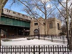 Entrance to Parkchester station
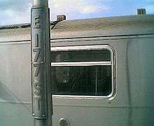 The lampposts at the station, which still read "E 177 ST"
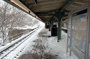 Snow on the platform
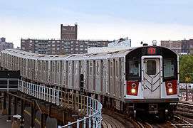 A R142A train approaching Parkchester
References
- 1 2 "Bronx Subway Extension Opened" (PDF). New York Times. May 28, 1920. Retrieved January 25, 2016.
- ↑ "Station Developers' Information". Metropolitan Transportation Authority. Retrieved June 13, 2017.
- ↑ "Facts and Figures: Annual Subway Ridership 2012–2017". Metropolitan Transportation Authority. July 12, 2018. Retrieved July 12, 2018.
- ↑ "MTA Neighborhood Maps: Bronx Zoo" (PDF). mta.info. Metropolitan Transportation Authority. 2015. Retrieved July 20, 2016.
External links
| Wikimedia Commons has media related to Parkchester (IRT Pelham Line). |
- nycsubway.org – IRT Pelham Line: East 177th Street/Parkchester
- nycsubway.org — Live the Dream Artwork (Artist and date unknown)
- Station Reporter — 6 Train
- Map of Bronx Subways
- The Subway Nut — Parkchester – East 177th Street Pictures
- Hugh Grant Circle (west) entrance from Google Maps Street View
- Hugh Grant Circle (east) entrance from Google Maps Street View
- Platforms from Google Maps Street View
| Pelham Line |
|
|---|---|
| |