Kingsbridge Road (IRT Jerome Avenue Line)
Kingsbridge Road | |||||||
|---|---|---|---|---|---|---|---|
|
| |||||||
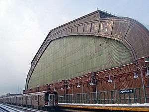 Platform view, with Kingsbridge Armory | |||||||
| Station statistics | |||||||
| Address |
Kingsbridge Road & Jerome Avenue Bronx, NY 10468 | ||||||
| Borough | The Bronx | ||||||
| Locale | Kingsbridge Heights, Fordham | ||||||
| Coordinates | 40°52′03″N 73°53′51″W / 40.867444°N 73.897433°WCoordinates: 40°52′03″N 73°53′51″W / 40.867444°N 73.897433°W | ||||||
| Division | A (IRT) | ||||||
| Line | IRT Jerome Avenue Line | ||||||
| Services |
4 | ||||||
| Transit connections |
| ||||||
| Structure | Elevated | ||||||
| Platforms | 2 side platforms | ||||||
| Tracks | 3 (2 in regular service) | ||||||
| Other information | |||||||
| Opened | June 2, 1917 | ||||||
| Station code | 381[1] | ||||||
| Traffic | |||||||
| Passengers (2017) |
3,024,692[2] | ||||||
| Rank | 169 out of 425 | ||||||
| Station succession | |||||||
| Next north |
Bedford Park Boulevard–Lehman College: 4 | ||||||
| Next south |
Fordham Road: 4 | ||||||
| |||||||
| |||||||
| |||||||


Kingsbridge Road is a rehabilitated local station on the elevated IRT Jerome Avenue Line of the New York City Subway. Located at the intersection of Kingsbridge Road and Jerome Avenue in the Bronx, it is served by the 4 train at all times.
Station layout
| P Platform level |
Side platform, doors will open on the right | |
| Northbound local | ← | |
| Peak-direction express | No regular service | |
| Southbound local | | |
| Side platform, doors will open on the right | ||
| M | Mezzanine | Fare control, station agent, MetroCard machines |
| G | Street level | Entrances/exits |
The station has three tracks and two side platforms. The middle track is generally not used in revenue service. It is a typical IRT elevated station. The Kingsbridge Armory rises immediately to the west of the station.
Kingsbridge Road station was originally opened on June 2, 1917, and was the original northern terminus of the line until April 15, 1918 when the line was extended to Woodlawn.
Exits
The station has a wooden mezzanine under the tracks. Exit stairs go to both northern corners of Jerome Avenue and Kingsbridge Road. There are two stairs to the northeast corner and one to the northwest.[3]
References
- ↑ "Station Developers' Information". Metropolitan Transportation Authority. Retrieved June 13, 2017.
- ↑ "Facts and Figures: Annual Subway Ridership 2012–2017". Metropolitan Transportation Authority. July 12, 2018. Retrieved July 12, 2018.
- ↑ "MTA Neighborhood Maps: Van Cortlandt Park / NY Botanical Garden" (PDF). Metropolitan Transportation Authority. 2015. Retrieved 7 October 2015.
External links

- nycsubway.org – IRT Woodlawn Line: Kingsbridge Road
- nycsubway.org — Urban Motif Artwork by Mario M. Muller (2006)
- Station Reporter — 4 Train
- The Subway Nut — Kingsbridge Road Pictures
- MTA's Arts For Transit — Kingsbridge Road (IRT Jerome Avenue Line)
- Kingsbridge Road entrance from Google Maps Street View
- Platforms from Google Maps Street View
| Jerome Ave. Line |
|
|---|---|
| |