Rector Street (BMT Broadway Line)
Rector Street | |||||||||||
|---|---|---|---|---|---|---|---|---|---|---|---|
|
| |||||||||||
 Station platforms and tracks | |||||||||||
| Station statistics | |||||||||||
| Address |
Rector Street & Trinity Place New York, NY 10006 | ||||||||||
| Borough | Manhattan | ||||||||||
| Locale | Financial District | ||||||||||
| Coordinates | 40°42′28″N 74°00′47″W / 40.70771°N 74.013004°WCoordinates: 40°42′28″N 74°00′47″W / 40.70771°N 74.013004°W | ||||||||||
| Division | B (BMT) | ||||||||||
| Line | BMT Broadway Line | ||||||||||
| Services |
N R W | ||||||||||
| Transit connections |
| ||||||||||
| Structure | Underground | ||||||||||
| Platforms | 2 side platforms | ||||||||||
| Tracks | 2 | ||||||||||
| Other information | |||||||||||
| Opened | January 5, 1918[1] | ||||||||||
| Wireless service |
| ||||||||||
| Traffic | |||||||||||
| Passengers (2017) |
2,213,971[3] | ||||||||||
| Rank | 226 out of 425 | ||||||||||
| Station succession | |||||||||||
| Next north |
Cortlandt Street: N | ||||||||||
| Next south |
Whitehall Street–South Ferry: N | ||||||||||
| |||||||||||
| |||||||||||
| |||||||||||


Rector Street is a local station on the BMT Broadway Line of the New York City Subway. Located at the corner of Rector Street and Trinity Place in Financial District, Lower Manhattan, the station is served by the R train at all times except late nights, when the N train takes over service. The W train also serves this station on weekdays.
Station layout
| G | Street Level | Exit/Entrance |
| B1 Platform level |
Side platform, doors will open on the right | |
| Northbound | ← ← | |
| Southbound | → → → | |
| Side platform, doors will open on the right | ||
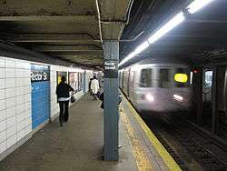
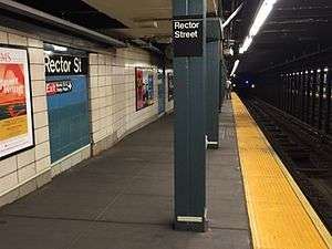
Since the station is on a grade, there is a noticeable slant. The station has two side platforms, and there are no overpasses, underpasses, or mezzanines to connect the platforms within fare control. This station was overhauled in the late 1970s. The overhaul changed the station's structure and the overall appearance, replacing the original wall tiles, old signs, and incandescent lighting to the 1970s-style wall tiles, signs and fluorescent lights. It also modernized staircases and platform edges. The blue tiles, which are not standard in BMT stations, provide the backdrop to the lettering, similar to Prospect Avenue station in Brooklyn.
The uptown platform maintains one old style sign while at the north end of the downtown/Brooklyn platform is an entire closed off portion of the platform. There are several (painted over) old style Rector Street mosaic signs on this platform.
Exits
Each platform has its own platform-level fare controls. The full-time exit is at the north end of the station, at Rector Street and Trinity Place. The uptown platform contains a token booth and three street stairs: two to the northeast corner of the aforementioned intersection, and one to the southeast corner. The downtown platform is unstaffed and has four street stairs: two to the southwest corner and two to the northwest corner.[4][5]
Just south of the fare control for the downtown platform, there are two exit-only turnstiles leading to an exit-only stair to the western side of Trinity Place.[4][5]
At the extreme south end of the station, there is another street stair from the uptown platform to the northwest corner of Greenwich and Morris Streets.[4][5]
Lower Manhattan transit | |||||||||||||||||||||||||||||||||||||||||||||||||||||||||||||||||||||||||||||||||||||||||||||||||||||||||||||||||||||||||||||||||||||||||||||||||||||||||||||||||||||||||||||||||||||||||||||||||||||||
|---|---|---|---|---|---|---|---|---|---|---|---|---|---|---|---|---|---|---|---|---|---|---|---|---|---|---|---|---|---|---|---|---|---|---|---|---|---|---|---|---|---|---|---|---|---|---|---|---|---|---|---|---|---|---|---|---|---|---|---|---|---|---|---|---|---|---|---|---|---|---|---|---|---|---|---|---|---|---|---|---|---|---|---|---|---|---|---|---|---|---|---|---|---|---|---|---|---|---|---|---|---|---|---|---|---|---|---|---|---|---|---|---|---|---|---|---|---|---|---|---|---|---|---|---|---|---|---|---|---|---|---|---|---|---|---|---|---|---|---|---|---|---|---|---|---|---|---|---|---|---|---|---|---|---|---|---|---|---|---|---|---|---|---|---|---|---|---|---|---|---|---|---|---|---|---|---|---|---|---|---|---|---|---|---|---|---|---|---|---|---|---|---|---|---|---|---|---|---|---|
| |||||||||||||||||||||||||||||||||||||||||||||||||||||||||||||||||||||||||||||||||||||||||||||||||||||||||||||||||||||||||||||||||||||||||||||||||||||||||||||||||||||||||||||||||||||||||||||||||||||||
Image gallery
 Remaining part of the original tiles and mosaics on the uptown platform
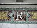 Mosaic
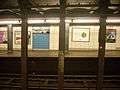 Slant of the platform, this station being on a grade
 Part of the platform on the southern side that is walled off
 Station slope
References
- ↑ New York Times, Open New Subway to Times Square, January 6, 1918
- ↑ "NYC Subway Wireless – Active Stations". Transit Wireless Wifi. Retrieved May 18, 2016.
- ↑ "Facts and Figures: Annual Subway Ridership 2012–2017". Metropolitan Transportation Authority. July 12, 2018. Retrieved July 12, 2018.
- 1 2 3 Cox, Jeremiah. "Rector Street (R)". The SubwayNut. Retrieved January 2, 2017.
- 1 2 3 "MTA Neighborhood Maps: Lower Manhattan" (PDF). mta.info. Metropolitan Transportation Authority. 2015. Retrieved August 21, 2015.
External links
| Wikimedia Commons has media related to Rector Street (BMT Broadway Line). |
- nycsubway.org – BMT Broadway Line: Rector Street
- Station Reporter — N Train
- Station Reporter — R Train
- Rector Street entrance from Google Maps Street View
- entrance near Brooklyn Battery Tunnel from Google Maps Street View
- Platforms from Google Maps Street View