Nereid Avenue (IRT White Plains Road Line)
Nereid Avenue | |||||||||
|---|---|---|---|---|---|---|---|---|---|
|
| |||||||||
 Southbound platform | |||||||||
| Station statistics | |||||||||
| Address |
Nereid Avenue (East 238th Street) & White Plains Road Bronx, NY 10466 | ||||||||
| Borough | The Bronx | ||||||||
| Locale | Wakefield | ||||||||
| Coordinates | 40°53′53″N 73°51′14″W / 40.898°N 73.854°WCoordinates: 40°53′53″N 73°51′14″W / 40.898°N 73.854°W | ||||||||
| Division | A (IRT) | ||||||||
| Line | IRT White Plains Road Line | ||||||||
| Services |
2 5 | ||||||||
| Transit connections |
| ||||||||
| Structure | Elevated | ||||||||
| Platforms | 2 side platforms | ||||||||
| Tracks | 3 (2 in regular service) | ||||||||
| Other information | |||||||||
| Opened | March 31, 1917 | ||||||||
| Station code | 417[1] | ||||||||
| Former/other names |
East 238th Street 238th Street–Nereid Avenue Nereid Avenue–238th Street | ||||||||
| Traffic | |||||||||
| Passengers (2017) |
1,085,289[2] | ||||||||
| Rank | 343 out of 425 | ||||||||
| Station succession | |||||||||
| Next north |
Wakefield–241st Street: 2 (Terminal): 5 | ||||||||
| Next south |
233rd Street: 2 | ||||||||
| |||||||||
| |||||||||
| |||||||||


Nereid Avenue (/ˈnɪəriɪd/; formerly East 238th Street; is a local station on the IRT White Plains Road Line of the New York City Subway, located at the intersection of Nereid Avenue (East 238th Street) and White Plains Road in the Bronx.[3] It is served by the 2 train at all times and by the 5 train during rush hours in the peak direction. Nereid Avenue is the northern terminal for most peak-direction rush-hour 5 trains that use this branch. All 2 trains terminate at the next stop, Wakefield–241st Street.[4][5]
Station layout
| P Platform level |
Side platform, doors will open on the right | |
| Southbound local | ← ← | |
| Peak-direction express | No regular service | |
| Northbound local | | |
| Side platform, doors will open on the right | ||
| M | Mezzanine | Fare control, station agent, MetroCard machines |
| G | Street level | Exit/entrance |
This station was the terminal of the White Plains Road line when the station opened on March 31, 1917.[6]
This station has three tracks and two side platforms. At the north end of the station, the northbound track ascends to pass over yard leads, while the others descend. A three-story tower is located north of the station which has an old blue and white letter sign "Warning — Do not lean over edge of Platform." North of this tower, two tracks enter the line from the 239th Street Yard.[7]
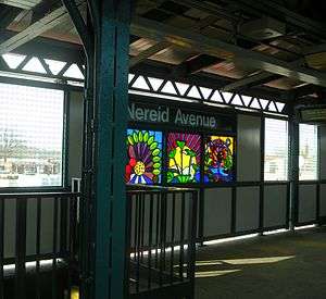
The 2006 artwork here is called Leaf of Life by Noel Copeland.[8][9]
Exits
This station has one elevated station house beneath the center of the platforms and tracks. Two staircases from each platform go down to a waiting area. Outside fare control, two staircases go down to the northwest and southeast corners of Nereid Avenue and White Plains Road.[10]
References
- ↑ "Station Developers' Information". Metropolitan Transportation Authority. Retrieved June 13, 2017.
- ↑ "Facts and Figures: Annual Subway Ridership 2012–2017". Metropolitan Transportation Authority. July 12, 2018. Retrieved July 12, 2018.
- ↑ "Neighborhood Map Woodlawn, Wakefield, Williamsbridge" (PDF). mta.info. Metropolitan Transportation Authority. 2015. Retrieved September 30, 2016.
- ↑ "2 Subway Timetable, Effective June 24, 2018" (PDF). Metropolitan Transportation Authority. Retrieved June 24, 2018.
- ↑ "5 Subway Timetable, Effective June 24, 2018" (PDF). Metropolitan Transportation Authority. Retrieved June 24, 2018.
- ↑ "New Subway Line Opened: White Plains Extension is Now Running to 238th Street" (PDF). New York Times. April 1, 1917. Retrieved December 20, 2015.
- ↑ Dougherty, Peter (2006) [2002]. Tracks of the New York City Subway 2006 (3rd ed.). Dougherty. OCLC 49777633 – via Google Books.
- ↑ "www.nycsubway.org: Artwork: Leaf of Life (Noel Copeland)". www.nycsubway.org. Retrieved September 30, 2016.
- ↑ "MTA - Arts & Design | NYCT Permanent Art". web.mta.info. Retrieved September 30, 2016.
- ↑ "MTA Neighborhood Maps: Woodlawn" (PDF). mta.info. Metropolitan Transportation Authority. 2015. Retrieved July 20, 2016.
External links
| Wikimedia Commons has media related to Nereid Avenue (IRT White Plains Road Line). |
- nycsubway.org – IRT White Plains Road Line: 238th Street (Nereid Avenue)
- nycsubway.org — Leaf of Life Artwork by Noel Copeland (2006)
- Station Reporter — 2 Train
- The Subway Nut — Nereid Avenue – 238th Street Pictures
- MTA's Arts For Transit — Nereid Avenue – 238th Street (IRT White Plains Road Line)
- Nereid Avenue entrance from Google Maps Street View
- Platforms from Google Maps Street View
| White Plains Rd. Line |
|
|---|---|
| |