Morrison Avenue–Soundview (IRT Pelham Line)
Morrison Avenue–Soundview | |||||||
|---|---|---|---|---|---|---|---|
|
| |||||||
 | |||||||
| Station statistics | |||||||
| Address |
Morrison Avenue & Westchester Avenue Bronx, NY 10472 | ||||||
| Borough | The Bronx | ||||||
| Locale | Soundview | ||||||
| Coordinates | 40°49′46″N 73°52′28″W / 40.829495°N 73.874474°WCoordinates: 40°49′46″N 73°52′28″W / 40.829495°N 73.874474°W | ||||||
| Division | A (IRT) | ||||||
| Line | IRT Pelham Line | ||||||
| Services |
6 | ||||||
| Transit connections |
⛴ NYC Ferry: Soundview route (at Soundview Park) | ||||||
| Structure | Elevated | ||||||
| Platforms | 2 side platforms | ||||||
| Tracks | 3 | ||||||
| Other information | |||||||
| Opened | May 30, 1920 | ||||||
| Rebuilt | February 8, 2010 to September 13, 2010 | ||||||
| Station code | 368[1] | ||||||
| Former/other names |
Sound View Avenue Morrison–Sound View Avenues Morrison Avenue–Sound View Avenue | ||||||
| Traffic | |||||||
| Passengers (2017) |
2,125,767[2] | ||||||
| Rank | 234 out of 425 | ||||||
| Station succession | |||||||
| Next north |
St. Lawrence Avenue: 6 | ||||||
| Next south |
Elder Avenue: 6 | ||||||
| |||||||
| |||||||
| |||||||


Morrison Avenue–Soundview[3] is a local station on the IRT Pelham Line of the New York City Subway. It is served by the 6 train at all times and is located at Morrison Avenue and Westchester Avenue in the Soundview neighborhood of the Bronx.
History
The station opened on May 30, 1920 as Sound View Avenue and has also been known as Morrison Avenue–Sound View Avenue and Morrison–Sound View Avenues.[4] The station was opened as the Pelham Line was extended to East 177th Street from Hunts Point Avenue.[5][6] The construction of the Pelham Line was part of the Dual Contracts, signed on March 19, 1913 and also known as the Dual Subway System.[7] The Pelham Line was built as a branch of the Lexington Avenue Line running northeast via 138th Street, Southern Boulevard and Westchester Avenue.[8] Initially, service to the extension was served by a shuttle service operating with elevated cars. Passengers transferred to the shuttle at Hunts Point Avenue.[9]
In 1981, the MTA listed the station among the 69 most deteriorated stations in the subway system.[10]
Station layout
| P Platform level |
Side platform, doors will open on the right | |
| Southbound local | ← | |
| Peak-direction express | ← | |
| Northbound local | | |
| Side platform, doors will open on the right | ||
| M | Mezzanine | Fare control, station agent, MetroCard machines |
| G | Street level | Exit/entrance |
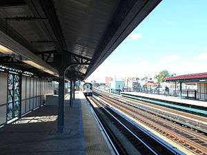
This elevated station has three tracks and two side platforms. The center track is used by the <6> train on weekdays in the peak direction.[11] The platforms have beige windscreen, green canopies, and red roofs in the center and waist-level black steel fence at both ends.
Exits
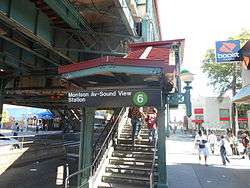
Two staircases from each platform lead to the wooden elevated mezzanine beneath the tracks. The station house has a turnstile bank, token booth, and three street staircases to all four corners of Morrison and Westchester Avenues except for the southeast one.[12]
References
- ↑ "Station Developers' Information". Metropolitan Transportation Authority. Retrieved June 13, 2017.
- ↑ "Facts and Figures: Annual Subway Ridership 2012–2017". Metropolitan Transportation Authority. July 12, 2018. Retrieved July 12, 2018.
- ↑ "Subway Map" (PDF). Metropolitan Transportation Authority. January 18, 2018. Retrieved January 18, 2018.
- ↑ "Bronx Subway Extension Opened" (PDF). New York Times. May 28, 1920. Retrieved January 25, 2016.
- ↑ Brooklyn Daily Eagle Almanac. Brooklyn Daily Eagle. 1922. p. 372.
- ↑ Annual Report for the Year Ending June 30, 1920. Interborough Rapid Transit Company. 1920. pp. 5, 13.
- ↑ nycsubway.org—The Dual Contracts
- ↑ "The Dual System of Rapid Transit (1912)". www.nycsubway.org. Retrieved March 25, 2014.
- ↑ Cunningham, Joseph; DeHart, Leonard O. (1993). A History of the New York City Subway System. J. Schmidt, R. Giglio, and K. Lang. p. 48.
- ↑ Gargan, Edward A. (June 11, 1981). "AGENCY LISTS ITS 69 MOST DETERIORATED SUBWAY STATIONS". The New York Times. Retrieved August 13, 2016.
- ↑ Dougherty, Peter (2006) [2002]. Tracks of the New York City Subway 2006 (3rd ed.). Dougherty. OCLC 49777633 – via Google Books.
- ↑ "MTA Neighborhood Maps: Bronx Zoo" (PDF). mta.info. Metropolitan Transportation Authority. 2015. Retrieved July 20, 2016.
External links
| Wikimedia Commons has media related to Morrison Avenue – Soundview (IRT Pelham Line). |
- nycsubway.org – IRT Pelham Line: Morrison/Soundview Aves.
- The Subway Nut — Morrison–Soundview Avenues Pictures
- Morrison Avenue entrance from Google Maps Street View
- Platforms from Google Maps Street View
| |
| |
| Pelham Line |
|
|---|---|
| |