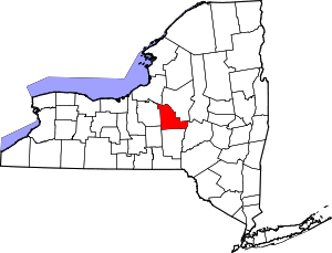
| [3] |
Name on the Register |
Image |
Date listed[4] |
Location |
City or town |
Description |
|---|
| 1 |
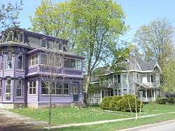
Abell Farmhouse and Barn |
|
November 2, 1987
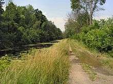
(#87001860) |
Ballina Rd.
42°54′11″N 75°49′31″W / 42.903056°N 75.825278°W / 42.903056; -75.825278 (Abell Farmhouse and Barn) |
Cazenovia |
|
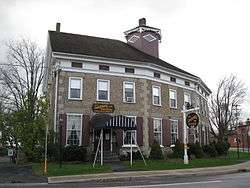
| 2 |
Albany Street Historic District |
|
October 10, 1978
(#78001859) |
Irregular pattern along Albany St.
42°55′47″N 75°51′19″W / 42.929722°N 75.855278°W / 42.929722; -75.855278 (Albany Street Historic District) |
Cazenovia |
|
| 3 |
Annas Farmhouse |
|
February 18, 1988
(#87001861) |
4812 Ridge Rd.
42°57′25″N 75°51′20″W / 42.956944°N 75.855556°W / 42.956944; -75.855556 (Annas Farmhouse) |
Cazenovia |
|
| 4 |
Beckwith Farmhouse |
|
November 2, 1987
(#87001862) |
4652 Syracuse Rd.
42°56′51″N 75°53′07″W / 42.9475°N 75.885278°W / 42.9475; -75.885278 (Beckwith Farmhouse) |
Cazenovia |
|
| 5 |
Brick House |
|
February 18, 1988
(#87001863) |
3318 Rippleton Rd.
42°54′22″N 75°52′22″W / 42.906111°N 75.872778°W / 42.906111; -75.872778 (Brick House) |
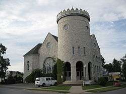
Cazenovia |
|
| 6 |
Canal Town Museum |
|
May 23, 1986
(#86001292) |
122 Canal St.
43°04′47″N 75°45′06″W / 43.079722°N 75.751667°W / 43.079722; -75.751667 (Canal Town Museum) |
Canastota |
|
| 7 |
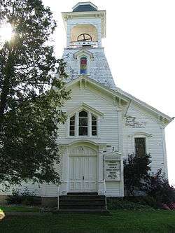
Canastota Methodist Church |
|
May 23, 1986
(#86001293) |
Main and New Boston Sts.
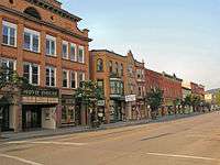
43°04′52″N 75°45′19″W / 43.081111°N 75.755278°W / 43.081111; -75.755278 (Canastota Methodist Church) |
Canastota |
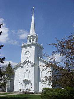
|
| 8 |
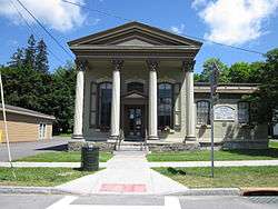
Canastota Public Library |
|
May 23, 1986
(#86001294) |
102 W. Center St.
43°04′42″N 75°45′20″W / 43.078333°N 75.755556°W / 43.078333; -75.755556 (Canastota Public Library) |
Canastota |
|
| 9 |
Cazenovia Village Historic District |
|
June 19, 1986
(#86001352) |
Roughly bounded by Union, Lincklean and Chenango Sts., and Rippleton Rd. and Foreman St.
42°55′43″N 75°51′24″W / 42.928611°N 75.856667°W / 42.928611; -75.856667 (Cazenovia Village Historic District) |
Cazenovia |
|
| 10 |
Cedar Cove |
|
July 15, 1991
(#91000867) |
W side of E. Lake Rd.
42°57′00″N 75°51′49″W / 42.95°N 75.863611°W / 42.95; -75.863611 (Cedar Cove) |
Cazenovia |
|
| 11 |
Chappell Farmhouse |
|
November 2, 1987
(#87001864) |
Ridge Rd.
42°56′52″N 75°51′23″W / 42.947778°N 75.856389°W / 42.947778; -75.856389 (Chappell Farmhouse) |
Cazenovia |
|
| 12 |
Chenango Canal Summit Level |
|
July 6, 2005
(#05000684) |
Along Canal Rd.
42°52′19″N 75°33′33″W / 42.871944°N 75.559167°W / 42.871944; -75.559167 (Chenango Canal Summit Level) |
Bouckville |
A portion of Chenango Canal |
| 13 |
Chittenango Landing Dry Dock Complex |
|
April 30, 1992
(#92000458) |
Lakeport Rd. at Old Erie Canal
43°03′36″N 75°52′26″W / 43.06°N 75.873889°W / 43.06; -75.873889 (Chittenango Landing Dry Dock Complex) |
Sullivan |
|
| 14 |
Chittenango Pottery |
|
December 11, 2009
(#09001083) |
11-13 Pottery St.
43°03′33″N 75°52′07″W / 43.059286°N 75.868719°W / 43.059286; -75.868719 (Chittenango Pottery) |
Chittenango |
New listing; refnum 09001083 |
| 15 |
Cobblestone House |
|
November 2, 1987
(#87001865) |
Syracuse Rd.
42°56′35″N 75°52′59″W / 42.943056°N 75.883056°W / 42.943056; -75.883056 (Cobblestone House) |
Cazenovia |
|
| 16 |
Zephnia Comstock Farmhouse |
|
November 2, 1987
(#87001866) |
2363 Nelson St.
42°55′30″N 75°50′19″W / 42.925°N 75.838611°W / 42.925; -75.838611 (Zephnia Comstock Farmhouse) |
Cazenovia |
|
| 17 |
Coolidge Stores Building |
|
January 26, 2001
(#00001686) |
US 20
42°53′21″N 75°33′07″W / 42.889167°N 75.551944°W / 42.889167; -75.551944 (Coolidge Stores Building) |
Bouckville |
|
| 18 |
Cottage Lawn |
|
November 6, 1980
(#80002650) |
435 Main St.
43°05′14″N 75°38′50″W / 43.087222°N 75.647222°W / 43.087222; -75.647222 (Cottage Lawn) |
Oneida |
|
| 19 |
Crandall Farm Complex |
|
November 2, 1987
(#87001867) |
2430 Ballina Rd.
42°53′35″N 75°50′13″W / 42.893056°N 75.836944°W / 42.893056; -75.836944 (Crandall Farm Complex) |
Cazenovia |
|
| 20 |
DeFerriere House |
|
March 1, 2007
(#07000097) |
2089 Genesee St.
43°04′26″N 75°41′39″W / 43.073831°N 75.694092°W / 43.073831; -75.694092 (DeFerriere House) |
Oneida |
|
| 21 |
Earlville Historic District |
|
October 29, 1982
(#82001096) |
Fayette, N., S., E., and W. Main Sts.
42°44′25″N 75°32′42″W / 42.740278°N 75.545°W / 42.740278; -75.545 (Earlville Historic District) |
Earlville |
|
| 22 |
Evergreen Acres |
|
November 2, 1987
(#87001868) |
Syracuse Rd.
42°55′38″N 75°52′38″W / 42.927222°N 75.877222°W / 42.927222; -75.877222 (Evergreen Acres) |
Cazenovia |
|
| 23 |
Fenner Baptist Church |
|
January 24, 2002
(#01001501) |
3122 Bingley Rd.
42°58′09″N 75°47′17″W / 42.969167°N 75.788056°W / 42.969167; -75.788056 (Fenner Baptist Church) |
Fenner |
|
| 24 |
First National Bank of Morrisville |
|
September 12, 1985
(#85002365) |
Main St.
42°53′56″N 75°38′37″W / 42.898889°N 75.643611°W / 42.898889; -75.643611 (First National Bank of Morrisville) |
Morrisville |
|
| 25 |
Hamilton Village Historic District |
|
September 13, 1984
(#84002494) |
Roughly Kendrick Ave., Broad, Payne, Hamilton, Madison, Pleasant and Lewbanon Sts.
42°49′22″N 75°32′33″W / 42.822778°N 75.5425°W / 42.822778; -75.5425 (Hamilton Village Historic District) |
Hamilton |
|
| 26 |
Hillcrest |
|
July 15, 1991
(#91000869) |
Ridge Rd. S of Hoffman
42°56′20″N 75°51′27″W / 42.938889°N 75.8575°W / 42.938889; -75.8575 (Hillcrest) |
Cazenovia |
|
| 27 |
House at 107 Stroud Street |
|
May 23, 1986
(#86001302) |
107 Stroud St.
43°04′27″N 75°45′41″W / 43.074167°N 75.761389°W / 43.074167; -75.761389 (House at 107 Stroud Street) |
Canastota |
|
| 28 |
House at 115 South Main Street |
|
May 23, 1986
(#86001289) |
115 S. Main St.
43°04′43″N 75°45′20″W / 43.078611°N 75.755556°W / 43.078611; -75.755556 (House at 115 South Main Street) |
Canastota |
|
| 29 |
House at 205 North Main Street |
|
May 23, 1986
(#86001296) |
205 N. Main St.
43°04′53″N 75°45′19″W / 43.081389°N 75.755278°W / 43.081389; -75.755278 (House at 205 North Main Street) |
Canastota |
|
| 30 |
House at 233 James Street |
|
May 23, 1986
(#86001295) |
233 James St.
43°04′31″N 75°45′35″W / 43.075278°N 75.759722°W / 43.075278; -75.759722 (House at 233 James Street) |
Canastota |
|
| 31 |
House at 313 North Main Street |
|
May 23, 1986
(#86001298) |
313 N. Main St.
43°05′03″N 75°45′18″W / 43.084167°N 75.755°W / 43.084167; -75.755 (House at 313 North Main Street) |
Canastota |
|
| 32 |
House at 326 North Peterboro Street |
|
May 23, 1986
(#86001299) |
326 N. Peterboro St.
43°05′08″N 75°45′01″W / 43.085556°N 75.750278°W / 43.085556; -75.750278 (House at 326 North Peterboro Street) |
Canastota |
|
| 33 |
House at 328 North Peterboro Street |
|
May 23, 1986
(#86001301) |
328 N. Peterboro St.
43°05′09″N 75°45′01″W / 43.085833°N 75.750278°W / 43.085833; -75.750278 (House at 328 North Peterboro Street) |
Canastota |
|
| 34 |
Lehigh Valley Railroad Depot |
|
July 15, 1991
(#91000874) |
William St.
42°55′58″N 75°50′56″W / 42.932778°N 75.848889°W / 42.932778; -75.848889 (Lehigh Valley Railroad Depot) |
Cazenovia |
|
| 35 |
Lenox District No. 4 Schoolhouse |
|
February 23, 1996
(#96000135) |
Timmerman Rd. N side, at jct. with Old Co. Rd.
43°02′31″N 75°44′32″W / 43.041944°N 75.742222°W / 43.041944; -75.742222 (Lenox District No. 4 Schoolhouse) |
Clockville |
|
| 36 |
Lorenzo |
|
February 18, 1971
(#71000541) |
Ledyard St. (U.S. 20)
42°55′23″N 75°51′56″W / 42.923056°N 75.865556°W / 42.923056; -75.865556 (Lorenzo) |
Cazenovia |
|
| 37 |
Main-Broad-Grove Streets Historic District |
|
September 15, 1983
(#83001705) |
Roughly bounded by Main, Broad, E. Grove, W. Grove, Wilbur, Elizabeth, E. Walnut, W. Walnut, and Stone Sts.
43°05′11″N 75°38′47″W / 43.086389°N 75.646389°W / 43.086389; -75.646389 (Main-Broad-Grove Streets Historic District) |
Oneida |
|
| 38 |
The Maples |
|
November 2, 1987
(#87001876) |
2420 Nelson Rd.
42°55′19″N 75°50′08″W / 42.921944°N 75.835556°W / 42.921944; -75.835556 (The Maples) |
Cazenovia |
|
| 39 |
Meadows Farm Complex |
|
November 2, 1987
(#87001869) |
Rippleton Rd.
42°55′01″N 75°51′40″W / 42.916944°N 75.861111°W / 42.916944; -75.861111 (Meadows Farm Complex) |
Cazenovia |
|
| 40 |
Middle Farmhouse |
|
November 2, 1987
(#87001870) |
4875 W. Lake Rd.
42°57′29″N 75°52′58″W / 42.958056°N 75.882778°W / 42.958056; -75.882778 (Middle Farmhouse) |
Cazenovia |
|
| 41 |
Morrisville Public Library |
|
October 5, 2005
(#05001126) |
87 East Main St.
42°53′56″N 75°38′35″W / 42.898889°N 75.643056°W / 42.898889; -75.643056 (Morrisville Public Library) |
Morrisville |
|
| 42 |
Mount Hope Reservoir |
|
August 29, 1997
(#97000981) |
Between Mt. Hope and Fairview Aves.
43°03′34″N 75°38′47″W / 43.059444°N 75.646389°W / 43.059444; -75.646389 (Mount Hope Reservoir) |
Oneida |
|
| 43 |
Nelson Methodist Episcopal Church |
|
April 17, 2017
(#100000894) |
3333 U.S. 20 E.
42°55′02″N 75°46′29″W / 42.91734°N 75.77485°W / 42.91734; -75.77485 (Nelson Methodist Episcopal Church) |
Nelson |
19th century wooden church |
| 44 |
Nelson Welsh Congregational Church |
|
August 6, 1993
(#93000681) |
Jct. of Welsh Church and Old State Rds.
42°54′07″N 75°45′17″W / 42.901944°N 75.754722°W / 42.901944; -75.754722 (Nelson Welsh Congregational Church) |
Nelson |
|
| 45 |
New York State Barge Canal |
|
October 15, 2014
(#14000860) |
Mainly Oneida Lake
43°09′51″N 75°48′52″W / 43.164100°N 75.814512°W / 43.164100; -75.814512 (New York State Barge Canal) |
Lenox, Sullivan |
Successor to Erie Canal approved by state voters in early 20th century to compete with railroads. |
| 46 |
Niles Farmhouse |
|
November 2, 1987
(#87001871) |
Rippleton Rd.
42°54′45″N 75°52′08″W / 42.9125°N 75.868889°W / 42.9125; -75.868889 (Niles Farmhouse) |
Cazenovia |
|
| 47 |
Notleymere |
|
July 15, 1991
(#91000868) |
4641 E. Lake Rd.
42°56′52″N 75°51′47″W / 42.947778°N 75.863056°W / 42.947778; -75.863056 (Notleymere) |
Cazenovia |
|
| 48 |
Old Biology Hall |
|
September 20, 1973
(#73001199) |
Colgate University
42°49′04″N 75°32′06″W / 42.817778°N 75.535°W / 42.817778; -75.535 (Old Biology Hall) |
Hamilton |
|
| 49 |
Old Madison County Courthouse |
|
June 15, 1978
(#78001860) |
E. Main St.
42°53′53″N 75°38′30″W / 42.898056°N 75.641667°W / 42.898056; -75.641667 (Old Madison County Courthouse) |
Morrisville |
|
| 50 |
Old Trees |
|
July 15, 1991
(#91000865) |
W side of Rippleton Rd.
42°54′59″N 75°52′35″W / 42.916389°N 75.876389°W / 42.916389; -75.876389 (Old Trees) |
Cazenovia |
|
| 51 |
Oneida Armory |
|
March 2, 1995
(#95000084) |
217 Cedar St.
43°05′36″N 75°39′01″W / 43.093333°N 75.650278°W / 43.093333; -75.650278 (Oneida Armory) |
Oneida |
|
| 52 |
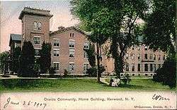
Oneida Community Mansion House |
|
October 15, 1966
(#66000527) |
Sherrill Rd.
43°03′37″N 75°36′19″W / 43.060278°N 75.605278°W / 43.060278; -75.605278 (Oneida Community Mansion House) |
Oneida |
|
| 53 |
Oneida Downtown Commercial Historic District |
|
July 13, 2018
(#100002667) |
Broad, Main & Cedar Sts., S of Elm, N of Washington
43°05′41″N 75°39′06″W / 43.0947°N 75.6517°W / 43.0947; -75.6517 (Oneida Downtown Commercial Historic District) |
Oneida |
|
| 54 |
Oneida Lake Congregational Church |
|
March 22, 2006
(#06000159) |
2508 NY 31
43°09′28″N 75°49′45″W / 43.157778°N 75.829167°W / 43.157778; -75.829167 (Oneida Lake Congregational Church) |
Oneida Lake |
|
| 55 |
Ormonde |
|
July 15, 1991
(#91000866) |
Between E. Lake Rd. and Ormonde Dr.
42°57′20″N 75°51′41″W / 42.955556°N 75.861389°W / 42.955556; -75.861389 (Ormonde) |
Cazenovia |
|
| 56 |
Parker Farmhouse |
|
November 2, 1987
(#87001872) |
3981 East Rd.
42°54′58″N 75°51′04″W / 42.916111°N 75.851111°W / 42.916111; -75.851111 (Parker Farmhouse) |
Cazenovia |
|
| 57 |
Peterboro Land Office |
|
September 7, 1984
(#84002498) |
Peterboro Rd.
42°58′03″N 75°41′14″W / 42.9675°N 75.687222°W / 42.9675; -75.687222 (Peterboro Land Office) |
Peterboro |
|
| 58 |
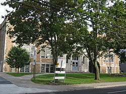
Peterboro Street Elementary School |
|
May 23, 1986
(#86001304) |
220 N. Peterboro St.
43°04′54″N 75°45′00″W / 43.081667°N 75.75°W / 43.081667; -75.75 (Peterboro Street Elementary School) |
Canastota |
|
| 59 |
Dorothy Riester House and Studio |
|
March 19, 2014
(#14000066) |
3883 Stone Quarry Rd.
42°54′42″N 75°50′04″W / 42.911779°N 75.834445°W / 42.911779; -75.834445 (Dorothy Riester House and Studio) |
Cazenovia |
|
| 60 |
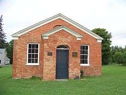
Rippleton Schoolhouse |
|
August 6, 1998
(#98000996) |
Rippleton Rd., 15 mi. SE of Syracuse
42°55′16″N 75°51′46″W / 42.921111°N 75.862778°W / 42.921111; -75.862778 (Rippleton Schoolhouse) |
Cazenovia |
|
| 61 |
Judge Nathan S. Roberts House |
|
May 23, 1986
(#86001305) |
W. Seneca Ave.
43°04′06″N 75°45′32″W / 43.068333°N 75.758889°W / 43.068333; -75.758889 (Judge Nathan S. Roberts House) |
Canastota |
|
| 62 |
Rolling Ridge Farm |
|
November 2, 1987
(#87001873) |
3937 Number Nine Rd.
42°54′46″N 75°50′45″W / 42.912778°N 75.845833°W / 42.912778; -75.845833 (Rolling Ridge Farm) |
Cazenovia |
|
| 63 |
Seventh Day Baptist Church |
|
October 5, 2005
(#05001136) |
Utica St.
42°45′40″N 75°53′07″W / 42.761111°N 75.885278°W / 42.761111; -75.885278 (Seventh Day Baptist Church) |
DeRuyter |
|
| 64 |
Shattuck House |
|
July 15, 1991
(#91000873) |
W. Lake Rd.
42°58′16″N 75°53′04″W / 42.971111°N 75.884444°W / 42.971111; -75.884444 (Shattuck House) |
Cazenovia |
|
| 65 |
Adon Smith House |
|
May 2, 1974
(#74001256) |
3 Broad St.
42°49′37″N 75°32′36″W / 42.826944°N 75.543333°W / 42.826944; -75.543333 (Adon Smith House) |
Hamilton |
|
| 66 |
Gerrit Smith Estate |
|
November 24, 1997
(#97001386) |
Jct. of Main and Nelson Sts.
42°58′05″N 75°41′13″W / 42.968056°N 75.686944°W / 42.968056; -75.686944 (Gerrit Smith Estate) |
Peterboro |
|
| 67 |
Smithfield Presbyterian Church |
|
December 12, 1994
(#94001370) |
Pleasant Valley Rd. between Elizabeth and Park Sts.
42°57′56″N 75°41′17″W / 42.965556°N 75.688056°W / 42.965556; -75.688056 (Smithfield Presbyterian Church) |
Peterboro |
|
| 68 |
South Peterboro Street Commercial Historic District |
|
May 23, 1986
(#86001287) |
Roughly bounded by NY 76, Diamond St., Penn Central RR tracks, and Commerce Ave.
43°04′41″N 75°45′06″W / 43.078056°N 75.751667°W / 43.078056; -75.751667 (South Peterboro Street Commercial Historic District) |
Canastota |
|
| 69 |
South Peterboro Street Residential Historic District |
|
May 23, 1986
(#86001288) |
S. Peterboro St. between Terrace and Rasbach Sts.
43°04′30″N 75°45′09″W / 43.075°N 75.7525°W / 43.075; -75.7525 (South Peterboro Street Residential Historic District) |
Canastota |
|
| 70 |
Spirit House |
|
March 22, 2006
(#06000160) |
NY 26
42°40′32″N 75°44′15″W / 42.675556°N 75.7375°W / 42.675556; -75.7375 (Spirit House) |
Georgetown |
|
| 71 |
St. Paul's Church |
|
August 30, 1996
(#96000956) |
204 Genesee St.
43°02′37″N 75°52′00″W / 43.043611°N 75.866667°W / 43.043611; -75.866667 (St. Paul's Church) |
Chittenango |
|
| 72 |
Sweetland Farmhouse |
|
November 2, 1987
(#87001874) |
Number Nine Rd.
42°54′52″N 75°50′44″W / 42.914444°N 75.845556°W / 42.914444; -75.845556 (Sweetland Farmhouse) |
Cazenovia |
|
| 73 |
Tall Pines |
|
November 2, 1987
(#87001875) |
Ridge Rd.
42°57′03″N 75°51′23″W / 42.950833°N 75.856389°W / 42.950833; -75.856389 (Tall Pines) |
Cazenovia |
|
| 74 |
The Hickories |
|
July 15, 1991
(#91000870) |
47 Forman St.
42°56′04″N 75°51′37″W / 42.934444°N 75.860278°W / 42.934444; -75.860278 (The Hickories) |
Cazenovia |
|
| 75 |
United Church of Canastota |
|
May 23, 1986
(#86001306) |
144 W. Center St.
43°04′42″N 75°45′14″W / 43.078333°N 75.753889°W / 43.078333; -75.753889 (United Church of Canastota) |
Canastota |
|
| 76 |
Upenough |
|
July 15, 1991
(#91000871) |
Rippleton St.
42°54′12″N 75°52′34″W / 42.903333°N 75.876111°W / 42.903333; -75.876111 (Upenough) |
Cazenovia |
|
| 77 |
US Post Office-Canastota |
|
November 17, 1988
(#88002467) |
118 S. Peterboro St.
43°04′43″N 75°45′05″W / 43.078611°N 75.751389°W / 43.078611; -75.751389 (US Post Office-Canastota) |
Canastota |
|
| 78 |
US Post Office-Hamilton |
|
May 11, 1989
(#88002522) |
32 Broad St.
42°49′00″N 75°32′40″W / 42.816667°N 75.544444°W / 42.816667; -75.544444 (US Post Office-Hamilton) |
Hamilton |
|
| 79 |
US Post Office-Oneida |
|
May 11, 1989
(#88002390) |
133 Farrier Ave.
43°05′39″N 75°39′12″W / 43.094167°N 75.653333°W / 43.094167; -75.653333 (US Post Office-Oneida) |
Oneida |
|
| 80 |
Wampsville Presbyterian Church |
|
February 2, 2018
(#100002075) |
109 Genesee St.
43°04′30″N 75°42′20″W / 43.07493°N 75.70547°W / 43.07493; -75.70547 (Wampsville Presbyterian Church) |
Wampsville |
1830 church, converted from meeting house, was first one in Wampsville; has been altered several times since but retains basic form |
| 81 |
Wheeler House Complex |
|
September 22, 1983
(#83001706) |
NY 8
42°48′32″N 75°15′10″W / 42.808889°N 75.252778°W / 42.808889; -75.252778 (Wheeler House Complex) |
Leonardsville |
|
| 82 |
York Lodge |
|
July 15, 1991
(#91000872) |
4448 E. Lake Rd.
42°56′21″N 75°51′29″W / 42.939167°N 75.858056°W / 42.939167; -75.858056 (York Lodge) |
Cazenovia |
|
.jpg)