| [3] |
Name on the Register |
Image |
Date listed[4] |
Location |
City or town |
Description |
|---|
| 1 |
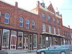
Bainbridge Historic District |
|
November 9, 1982
(#82001095) |
E. Main, Juliand, N. Main, Pearl, S. Main, and W. Main Sts., Park Pl. and Railroad Ave.
42°17′41″N 75°28′46″W / 42.294722°N 75.479444°W / 42.294722; -75.479444 (Bainbridge Historic District) |
Bainbridge |
|
| 2 |
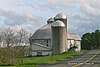
Bates Round Barn |
|
September 29, 1984
(#84002071) |
NY 12
42°18′10″N 75°48′07″W / 42.302778°N 75.801944°W / 42.302778; -75.801944 (Bates Round Barn) |
Greene |
|
| 3 |
Theodore Burr House |
|
September 11, 1981
(#81000402) |
Fort Hill Sq.
42°26′27″N 75°35′48″W / 42.440833°N 75.596667°W / 42.440833; -75.596667 (Theodore Burr House) |
Oxford |
|
| 4 |
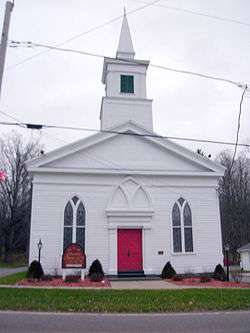
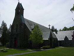
Calvary Episcopal Church |
|
February 20, 1998
(#98000130) |
North St., W of Moon Hill Rd.
42°29′58″N 75°46′05″W / 42.499444°N 75.768056°W / 42.499444; -75.768056 (Calvary Episcopal Church) |
McDonough |
|
| 5 |
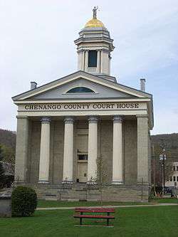
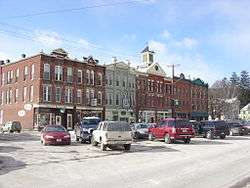
Chenango County Courthouse District |
|
June 10, 1975
(#75001178) |
Irregular pattern between Hayes and Mechanic Sts. and Maple Ave. and City Hall
42°31′53″N 75°31′27″W / 42.531389°N 75.524167°W / 42.531389; -75.524167 (Chenango County Courthouse District) |
Norwich |
|
| 6 |
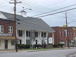
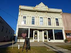
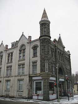
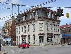
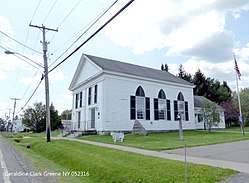
Clinton-Rosekrans Law Building |
|
July 27, 1979
(#79001569) |
62 Genesee St
42°19′47″N 75°46′15″W / 42.329722°N 75.770833°W / 42.329722; -75.770833 (Clinton-Rosekrans Law Building) |
Greene |
|
| 7 |
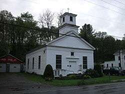
Columbus Community Church |
|
March 20, 1986
(#86000487) |
NY 80
42°41′01″N 75°22′24″W / 42.683611°N 75.373333°W / 42.683611; -75.373333 (Columbus Community Church) |
Columbus |
|
| 8 |
District School 2 |
|
February 25, 2004
(#04000096) |
Cty Rte 27
42°18′53″N 75°35′54″W / 42.314722°N 75.598333°W / 42.314722; -75.598333 (District School 2) |
Coventryville |
|
| 9 |
District School 4 |
|
April 21, 2004
(#04000353) |
NY 235
42°18′53″N 75°38′22″W / 42.314722°N 75.639444°W / 42.314722; -75.639444 (District School 4) |
Coventry |
|
| 10 |
Earlville Historic District |
|
October 29, 1982
(#82001096) |
Fayette and N., S., E., and W. Main Sts.
42°44′25″N 75°32′42″W / 42.740278°N 75.545000°W / 42.740278; -75.545000 (Earlville Historic District) |
Earlville |
|
| 11 |
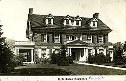
Eaton Family Residence-Jewish Center of Norwich |
|
June 4, 2009
(#09000375) |
72 S. Broad St.
42°31′38″N 75°31′24″W / 42.527339°N 75.523472°W / 42.527339; -75.523472 (Eaton Family Residence-Jewish Center of Norwich) |
Norwich |
|
| 12 |
Earlville Opera House |
|
January 22, 1973
(#73001169) |
12-20 E. Main St.
42°44′22″N 75°32′41″W / 42.739444°N 75.544722°W / 42.739444; -75.544722 (Earlville Opera House) |
Earlville |
|
| 13 |
Emmanuel Episcopal Church Complex |
|
August 26, 2009
(#09000654) |
37 W. Main St.
42°31′50″N 75°31′38″W / 42.530478°N 75.527261°W / 42.530478; -75.527261 (Emmanuel Episcopal Church Complex) |
Norwich |
|
| 14 |
Greene Historic District |
|
September 9, 1982
(#82003350) |
Chenango, Genesee, and Jackson Sts.
42°19′44″N 75°46′18″W / 42.328889°N 75.771667°W / 42.328889; -75.771667 (Greene Historic District) |
Greene |
|
| 15 |
Guildford Center Presbyterian Church |
|
September 24, 2004
(#04001059) |
Cty Rd. 36
42°24′23″N 75°27′53″W / 42.406389°N 75.464722°W / 42.406389; -75.464722 (Guildford Center Presbyterian Church) |
Guilford Center |
|
| 16 |
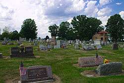
Guilford Center Cemetery |
|
October 5, 2005
(#05001129) |
Cty Rte. 36
42°24′29″N 75°27′57″W / 42.408056°N 75.465833°W / 42.408056; -75.465833 (Guilford Center Cemetery) |
Guilford Center |
|
| 17 |
Charles C. Hovey House and Strong Leather Company Mill |
|
December 6, 1996
(#96001426) |
53 W. Main St. and 10 Bixby St.
42°17′45″N 75°29′00″W / 42.295833°N 75.483333°W / 42.295833; -75.483333 (Charles C. Hovey House and Strong Leather Company Mill) |
Bainbridge |
|
| 18 |
Jewell Family Homestead |
|
January 31, 2017
(#100000611) |
120 Furnace Rd.
42°24′29″N 75°29′34″W / 42.407980°N 75.492743°W / 42.407980; -75.492743 (Jewell Family Homestead) |
Guilford |
1824 house built by New Hampshire family is well-preserved example of New England-style center-hall plan structure from that era. |
| 19 |
Loomis Family Farm |
|
June 13, 2014
(#14000329) |
414 S. Tyner Rd.
42°25′27″N 75°39′58″W / 42.424241°N 75.6661437°W / 42.424241; -75.6661437 (Loomis Family Farm) |
Oxford |
|
| 20 |
Main Street Historic District |
|
June 30, 1983
(#83001662) |
169-191 and 158-180 Main St.
42°13′41″N 75°31′36″W / 42.228056°N 75.526667°W / 42.228056; -75.526667 (Main Street Historic District) |
Afton |
|
| 21 |
Holden B. Mathewson House |
|
October 23, 2009
(#09000860) |
1567 NY 26
42°13′41″N 75°31′36″W / 42.228056°N 75.526667°W / 42.228056; -75.526667 (Holden B. Mathewson House) |
South Otselic |
|
| 22 |
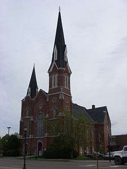
Methodist-Episcopal Church of Norwich |
|
August 28, 2003
(#03000846) |
74 N. Broad St.
42°32′01″N 75°31′26″W / 42.533611°N 75.523889°W / 42.533611; -75.523889 (Methodist-Episcopal Church of Norwich) |
Norwich |
|
| 23 |
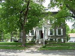
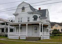
Horace O. Moss House |
|
May 17, 1974
(#74001224) |
45 S. Main St.
42°37′16″N 75°19′55″W / 42.621111°N 75.331944°W / 42.621111; -75.331944 (Horace O. Moss House) |
New Berlin |
|
| 24 |
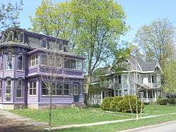
New Berlin Historic District |
|
August 12, 1982
(#82005025) |
Roughly along Main, West and Genesee Sts.
42°37′21″N 75°19′56″W / 42.6225°N 75.332222°W / 42.6225; -75.332222 (New Berlin Historic District) |
New Berlin |
|
| 25 |
Newton Homestead |
|
June 3, 1982
(#82003351) |
Ridge Rd.
42°39′04″N 75°47′08″W / 42.651111°N 75.785556°W / 42.651111; -75.785556 (Newton Homestead) |
South Otselic |
Octagon house built in 1860 |
| 26 |
North Broad Street Historic District |
|
November 21, 1978
(#78001845) |
Broad St.
42°32′14″N 75°31′30″W / 42.537222°N 75.525°W / 42.537222; -75.525 (North Broad Street Historic District) |
Norwich |
|
| 27 |
Oxford Village Historic District |
|
September 17, 1985
(#85002481) |
Roughly Washington Ave., State St., Chenango River, Merchant & Green Sts., Washington Park, Albany & Pleasant Sts.
42°26′27″N 75°35′40″W / 42.440833°N 75.594444°W / 42.440833; -75.594444 (Oxford Village Historic District) |
Oxford |
|
| 28 |
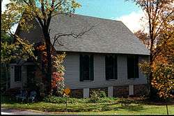
Phillips–Manning House |
|
March 13, 2017
(#100000754) |
154 Nursery St.
42°19′03″N 75°38′17″W / 42.31762°N 75.63817°W / 42.31762; -75.63817 (Phillips–Manning House) |
Coventry |
1840s Greek Revival house of two prominent families in town |
| 29 |
Rockdale Community Church |
|
October 5, 2005
(#05001128) |
NY 8
42°22′39″N 75°24′30″W / 42.3775°N 75.408333°W / 42.3775; -75.408333 (Rockdale Community Church) |
Rockdale |
|
| 30 |
Rockwells Mills Historic District |
|
August 30, 2010
(#10000610) |
NY 8 and Crandall Road
42°26′56″N 75°23′24″W / 42.448889°N 75.39°W / 42.448889; -75.39 (Rockwells Mills Historic District) |
Guilford |
|
| 31 |
Sannick Family Farm |
|
April 18, 2007
(#07000335) |
129 Jordan Ln.
42°23′27″N 75°36′59″W / 42.390805°N 75.616370°W / 42.390805; -75.616370 (Sannick Family Farm) |
South Oxford |
|
| 32 |
Sherburne High School |
|
November 3, 1988
(#88002185) |
16 Chapel St.
42°40′33″N 75°29′39″W / 42.675833°N 75.494167°W / 42.675833; -75.494167 (Sherburne High School) |
Sherburne |
|
| 33 |
Sherburne Historic District |
|
October 29, 1982
(#82001097) |
N. and S. Main, E. and W. State, Classic, Summit and Church Sts. and Park Ave.
42°40′37″N 75°29′38″W / 42.676944°N 75.493889°W / 42.676944; -75.493889 (Sherburne Historic District) |
Sherburne |
|
| 34 |
Smithville Valley Grange No. 1397 |
|
August 6, 1998
(#98001009) |
NY 41
42°23′57″N 75°48′33″W / 42.399167°N 75.809167°W / 42.399167; -75.809167 (Smithville Valley Grange No. 1397) |
Smithville Flats |
|
| 35 |
Smyrna Elementary School |
|
December 16, 1996
(#96001428) |
School St., SE of NY 80
42°41′10″N 75°34′12″W / 42.686111°N 75.57°W / 42.686111; -75.57 (Smyrna Elementary School) |
Smyrna |
|
| 36 |
Smyrna Town Hall-Opera House |
|
July 25, 2008
(#08000699) |
Academy Street
42°41′14″N 75°34′14″W / 42.687222°N 75.570556°W / 42.687222; -75.570556 (Smyrna Town Hall-Opera House) |
Smyrna |
|
| 37 |
South Otselic Historic District |
|
September 8, 1983
(#83001663) |
Gladding, N. and S. Main Sts., Clarence Church and Plank Rds., and Potter Ave.
42°38′48″N 75°46′52″W / 42.646667°N 75.781111°W / 42.646667; -75.781111 (South Otselic Historic District) |
South Otselic |
|
| 38 |
Upperville Meeting House |
|
April 1, 2002
(#02000307) |
NY 80
42°42′00″N 75°36′58″W / 42.7°N 75.616111°W / 42.7; -75.616111 (Upperville Meeting House) |
Upperville |
|
| 39 |
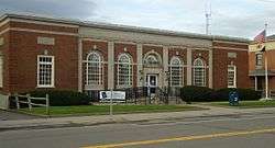
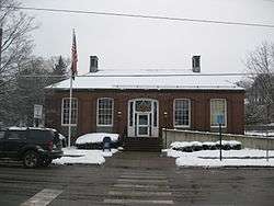
US Post Office-Norwich |
|
May 11, 1989
(#88002380) |
20-22 E. Main St.
42°31′51″N 75°31′20″W / 42.530833°N 75.522222°W / 42.530833; -75.522222 (US Post Office-Norwich) |
Norwich |
1932 building with elaborate classically-detailed stonework |
| 40 |
US Post Office-Oxford |
|
May 11, 1989
(#88002392) |
2 S. Washington Ave.[5]
42°26′32″N 75°35′56″W / 42.442222°N 75.598889°W / 42.442222; -75.598889 (US Post Office-Oxford) |
Oxford |
|
| 41 |
West Hill Cemetery |
|
January 18, 2006
(#05001534) |
NY 80
42°41′39″N 75°31′56″W / 42.694167°N 75.532222°W / 42.694167; -75.532222 (West Hill Cemetery) |
Sherburne |
|
| 42 |
White Store Church and Evergreen Cemetery |
|
February 10, 1995
(#95000047) |
Jct. of NY 8 and White Store Rd., 4 mi. S of South New Berlin
42°29′01″N 75°24′23″W / 42.483611°N 75.406389°W / 42.483611; -75.406389 (White Store Church and Evergreen Cemetery) |
Norwich |
|
| 43 |
Young Round Barn |
|
September 29, 1984
(#84002072) |
NY 12
42°17′39″N 75°48′28″W / 42.294167°N 75.807778°W / 42.294167; -75.807778 (Young Round Barn) |
Greene |
|