Van Siclen Avenue (BMT Jamaica Line)
Van Siclen Avenue | |||||||||
|---|---|---|---|---|---|---|---|---|---|
|
| |||||||||
 | |||||||||
| Station statistics | |||||||||
| Address |
Van Siclen Avenue & Fulton Street Brooklyn, NY 11207 | ||||||||
| Borough | Brooklyn | ||||||||
| Locale | East New York, Cypress Hills | ||||||||
| Coordinates | 40°40′41″N 73°53′30″W / 40.678002°N 73.891726°WCoordinates: 40°40′41″N 73°53′30″W / 40.678002°N 73.891726°W | ||||||||
| Division | B (BMT) | ||||||||
| Line |
BMT Jamaica Line BMT Lexington Avenue Line (formerly) | ||||||||
| Services |
J Z | ||||||||
| Transit connections |
| ||||||||
| Structure | Elevated | ||||||||
| Platforms | 1 island platform | ||||||||
| Tracks | 2 | ||||||||
| Other information | |||||||||
| Opened | December 3, 1885[1] | ||||||||
| Station code | 090[2] | ||||||||
| Traffic | |||||||||
| Passengers (2017) |
910,042[3] | ||||||||
| Rank | 370 out of 425 | ||||||||
| Station succession | |||||||||
| Next north |
Cleveland Street: J (Z | ||||||||
| Next south |
Alabama Avenue: J | ||||||||
| |||||||||
| |||||||||
| |||||||||


Van Siclen Avenue is a skip-stop station on the BMT Jamaica Line of the New York City Subway. Located at the intersection of Fulton Street and Van Siclen Avenue in Brooklyn,[4] it is served by the Z train during rush hours in the peak direction, and by the J train other times.[5]
History
The station opened on December 3, 1885 as part of a one station extension of the Lexington Avenue Line from Alabama Avenue.[1][6][7] This station was the eastern terminus of the line until May 30, 1893 when it was extended to Cypress Hills.[8] This station was closed from March 25, 2006 to August 6, 2006 in order to be rehabilitated. As part of the rehabilitation project, the stairs were rehabilitated, the floors were renewed, major structural repairs were made, new canopies were installed, the area around the station booth was reconfigured, the platform edge strips were replaced, walls were replaced, and a high-quality public address system was installed.[9]
Station layout
| P Platform level |
Southbound | ← ← |
| Island platform, doors will open on the left | ||
| Northbound | → → | |
| M | Mezzanine | Fare control, station agent |
| G | Street Level | Exit / Entrance |
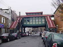
This elevated station has two tracks and one island platform.[10] The canopy is short and has a squared off, flat roof-line.
The artwork here, THE VIEW FROM HERE by Barbara Ellmann, was installed in 2007. This artwork is supposed to be evocative of structures in the surrounding area.[11][12][13]
Exit
The station's only entrance and exit is a center mezzanine under the tracks with wooden floors and walls. This mezzanine is to the geographic south of the northbound track. Outside of fare control, a single stair goes to the southwest corner of Fulton Street and Van Siclen Avenue.[14]
References
- 1 2 "Finished At Last The Elevated Complete from the River to Schenck Avenue". The Brooklyn Daily Eagle. December 3, 1885. p. 4. Retrieved October 2, 2016 – via Brooklyn Newspapers.
- ↑ "Station Developers' Information". Metropolitan Transportation Authority. Retrieved June 13, 2017.
- ↑ "Facts and Figures: Annual Subway Ridership 2012–2017". Metropolitan Transportation Authority. July 12, 2018. Retrieved July 12, 2018.
- ↑ "Neighborhood Map East New York Cypress Hills Woodhaven New Lots" (PDF). mta.info. Metropolitan Transportation Authority. 2015. Retrieved October 2, 2016.
- ↑ "J/Z Subway Timetable, Effective June 24, 2018" (PDF). Metropolitan Transportation Authority. Retrieved June 24, 2018.
- ↑ "BROOKLYN ELEVATED ROADS". The New York Times. 1885-12-04. ISSN 0362-4331. Retrieved 2016-10-02.
- ↑ "Five Hundred Passengers". The Brooklyn Daily Eagle. December 4, 1995. p. 6. Retrieved October 2, 2016 – via Brooklyn Newspapers.
- ↑ "Trains Running This Morning The Elevated Road to Cypress Hills Still in Operation". The Brooklyn Daily Eagle. May 30, 1893. p. 10. Retrieved October 2, 2016 – via Brooklyn Newspapers.
- ↑ "Van Siclen Av station closed for rehabilitation 12:01 AM Sat, Mar 25 to midnight Sun, Aug 6, 2006" (PDF). mta.info. New York City Transit. 2006. Archived from the original (PDF) on 2006-04-09. Retrieved October 2, 2016.
- ↑ Dougherty, Peter (2006) [2002]. Tracks of the New York City Subway 2006 (3rd ed.). Dougherty. OCLC 49777633 – via Google Books.
- ↑ "www.nycsubway.org: Artwork: The View From Here (Barbara Ellmann)". www.nycsubway.org. Retrieved 2016-10-02.
- ↑ "public works". 2014-09-04. Retrieved 2016-10-02.
- ↑ "MTA - Arts & Design | NYCT Permanent Art". web.mta.info. Retrieved 2016-10-02.
- ↑ "Neighborhood Map East New York Cypress Hills Woodhaven New Lots" (PDF). mta.info. Metropolitan Transportation Authority. 2015. Retrieved October 2, 2016.
External links
| Wikimedia Commons has media related to Van Siclen Avenue (BMT Jamaica Line). |
- nycsubway.org – BMT Jamaica Line: Van Siclen Avenue
- Station Reporter — J Train
- The Subway Nut — Van Siclen Avenue Pictures
- MTA's Arts For Transit — Van Siclen Avenue (BMT Jamaica Line)
- Van Siclen Avenue entrance from Google Maps Street View
- Platform from Google Maps Street View
- The View From Here, nycsubway.org
| Jamaica Line |
|
|---|---|
| |