Gun Hill Road (IRT Dyre Avenue Line)
Gun Hill Road | |||||||||||
|---|---|---|---|---|---|---|---|---|---|---|---|
|
| |||||||||||
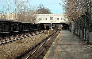 2006 photograph from the Dyre Avenue platform with a train beneath the station approaching the East 180th Street-bound platform. | |||||||||||
| Station statistics | |||||||||||
| Address |
East Gun Hill Road & Seymour Avenue Bronx, NY 10469 | ||||||||||
| Borough | The Bronx | ||||||||||
| Locale | Baychester, Allerton | ||||||||||
| Coordinates | 40°52′13″N 73°50′45″W / 40.87017°N 73.845806°WCoordinates: 40°52′13″N 73°50′45″W / 40.87017°N 73.845806°W | ||||||||||
| Division | A (IRT, formerly NYW&B) | ||||||||||
| Line | IRT Dyre Avenue Line | ||||||||||
| Services |
5 | ||||||||||
| Transit connections |
| ||||||||||
| Structure | Open-cut | ||||||||||
| Platforms | 2 side platforms | ||||||||||
| Tracks | 3 (2 in regular service) | ||||||||||
| Other information | |||||||||||
| Opened |
May 29, 1912 (NYW&B station) May 15, 1941 (re-opened as a Subway station) | ||||||||||
| Station code | 444[1] | ||||||||||
| Accessible | not ADA-accessible; accessibility planned | ||||||||||
| Former/other names | Gunhill Road | ||||||||||
| Traffic | |||||||||||
| Passengers (2017) |
1,555,601[2] | ||||||||||
| Rank | 297 out of 425 | ||||||||||
| Station succession | |||||||||||
| Next north |
Baychester Avenue: 5 | ||||||||||
| Next south |
Pelham Parkway: 5 | ||||||||||
| |||||||||||
| |||||||||||
| |||||||||||


Gun Hill Road is a station on the IRT Dyre Avenue Line of the New York City Subway, located at the intersection of Gun Hill Road and Seymour Avenue in the Baychester and Allerton sections of The Bronx. It is served by the 5 train at all times.
Station layout
| G | Street level station house | Exit/Entrance, fare control, station agent |
| P Platform level |
Side platform, doors will open on the right | |
| Northbound local | ← | |
| Northbound express | Trackbed | |
| Southbound express | No regular service | |
| Southbound local | → | |
| Side platform, doors will open on the right | ||
Originally opened on May 29, 1912 as a local station of the New York, Westchester and Boston Railway, the station was closed on December 12, 1937 when the NYW&B went bankrupt. In 1940, the City of New York purchased the right-of-way from the Bronx county line southward. In 1941, a shuttle service was implemented between Eastchester–Dyre Avenue and East 180th Street using IRT gate cars. In 1957, a physical connection was made to the IRT White Plains Road Line, and through service provided.
The station has two side platforms with three tracks and space for a fourth. It is in an open-cut. The street (Gun Hill Road) is above the northern part of the station. The entrance is at street level.
Exit
The station's only entrance/exit is a head house on the south side of Gun Hill Road between Sexton and Dewitt Places. The entrance and exit are separate from each other within the headhouse.[3]
References
- ↑ "Station Developers' Information". Metropolitan Transportation Authority. Retrieved June 13, 2017.
- ↑ "Facts and Figures: Annual Subway Ridership 2012–2017". Metropolitan Transportation Authority. July 12, 2018. Retrieved July 12, 2018.
- ↑ "MTA Neighborhood Maps: Pelham Parkway" (PDF). mta.info. Metropolitan Transportation Authority. 2015. Retrieved 20 July 2016.
External links
| Wikimedia Commons has media related to Gun Hill Road (IRT Dyre Avenue Line). |
- nycsubway.org – IRT White Plains Road Line: Gun Hill Road
- Station Reporter — 5 Train
- The Subway Nut — Gun Hill Road Pictures
- Gun Hill Road entrance from Google Maps Street View
- Platforms from Google Maps Street View
| Preceding station | New York, Westchester and Boston Railway | Following station | ||
|---|---|---|---|---|
| Former services | ||||
| Pelham Parkway | Main Line | Baychester Avenue | ||
Express | |
|---|---|
| |
| Dyre Ave. Line | |
|---|---|
| |