Whitlock Avenue (IRT Pelham Line)
Whitlock Avenue | |||||||
|---|---|---|---|---|---|---|---|
|
| |||||||
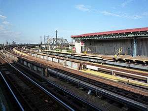 Whitlock Avenue station looking northeast toward the curve at the bridge over the Northeast Corridor and Bronx River. | |||||||
| Station statistics | |||||||
| Address |
Whitlock Avenue & Westchester Avenue Bronx, NY 10459 | ||||||
| Borough | The Bronx | ||||||
| Locale | Foxhurst | ||||||
| Coordinates | 40°49′39″N 73°53′10″W / 40.827514°N 73.886147°WCoordinates: 40°49′39″N 73°53′10″W / 40.827514°N 73.886147°W | ||||||
| Division | A (IRT) | ||||||
| Line | IRT Pelham Line | ||||||
| Services |
6 | ||||||
| Transit connections |
| ||||||
| Structure | Elevated | ||||||
| Platforms | 2 side platforms | ||||||
| Tracks | 3 | ||||||
| Other information | |||||||
| Opened | May 30, 1920 | ||||||
| Rebuilt | February 8, 2010 to September 13, 2010 | ||||||
| Station code | 370[1] | ||||||
| Traffic | |||||||
| Passengers (2017) |
595,385[2] | ||||||
| Rank | 398 out of 425 | ||||||
| Station succession | |||||||
| Next north |
Elder Avenue: 6 | ||||||
| Next south |
Hunts Point Avenue: 6 | ||||||
| |||||||
| |||||||
| |||||||


Whitlock Avenue is a local station on the IRT Pelham Line of the New York City Subway. It is served by the 6 train at all times and is located at Whitlock Avenue and Westchester Avenue in the Bronx.
History
The Whitlock Avenue station opened on May 30, 1920 as the Pelham Line was extended to East 177th Street from Hunts Point Avenue.[3][4][5] The construction of the Pelham Line was part of the Dual Contracts, signed on March 19, 1913 and also known as the Dual Subway System.[6] The Pelham Line was built as a branch of the Lexington Avenue Line running northeast via 138th Street, Southern Boulevard and Westchester Avenue.[7] Initially, service to the extension was served by a shuttle service operating with elevated cars. Passengers transferred to the shuttle at Hunts Point Avenue.[8]
Station layout
| P Platform level |
Side platform, doors will open on the right | |
| Southbound local | ← | |
| Peak-direction express | ← | |
| Northbound local | | |
| Side platform, doors will open on the right | ||
| M | Mezzanine | Fare control, station agent, MetroCard machines |
| G | Street level | Exit/entrance |
.jpg)
The station has three tracks and two side platforms, with the center express track used by the <6> service on weekdays in the peak direction.[9] The station has covered-over old signs and a windscreen on the south end. The north end has a full canopy over the platform.
The station is adjacent to an abandoned railroad station called Westchester Avenue which was served by the New York, Westchester and Boston Railroad (NYW&B), and the Harlem River Branch of the New York, New Haven and Hartford Railroad. Currently, the line is used by Amtrak. The former NYW&B line was at one time proposed to be converted into an extension of the IRT Dyre Avenue Line leading to this station, rather than its current terminus at East 180th Street on the IRT White Plains Road Line. The station is also located right next to the Sheridan Expressway.
Southbound, this is the last elevated station before the wholly underground stretch to Brooklyn Bridge station. Northbound, the line makes a right angle turn to the east and crosses the Bronx River via a bridge.
Exits
The mezzanine is wood and features frosted windows in a simulated 16-pane pattern. At one time there were doors to the fare control but they have been removed; doors from fare control to the street remain. Outside fare control, exit stairs lead to either southern corner of Westchester Avenue and Whitlock Avenue.[10]
References
- ↑ "Station Developers' Information". Metropolitan Transportation Authority. Retrieved June 13, 2017.
- ↑ "Facts and Figures: Annual Subway Ridership 2012–2017". Metropolitan Transportation Authority. July 12, 2018. Retrieved July 12, 2018.
- ↑ "Bronx Subway Extension Opened" (PDF). New York Times. May 28, 1920. Retrieved January 25, 2016.
- ↑ Brooklyn Daily Eagle Almanac. Brooklyn Daily Eagle. 1922. p. 372.
- ↑ Annual Report for the Year Ending June 30, 1920. Interborough Rapid Transit Company. 1920. pp. 5, 13.
- ↑ nycsubway.org—The Dual Contracts
- ↑ "The Dual System of Rapid Transit (1912)". www.nycsubway.org. Retrieved March 25, 2014.
- ↑ Cunningham, Joseph; DeHart, Leonard O. (1993). A History of the New York City Subway System. J. Schmidt, R. Giglio, and K. Lang. p. 48.
- ↑ Dougherty, Peter (2006) [2002]. Tracks of the New York City Subway 2006 (3rd ed.). Dougherty. OCLC 49777633 – via Google Books.
- ↑ "MTA Neighborhood Maps: Bronx Zoo" (PDF). mta.info. Metropolitan Transportation Authority. 2015. Retrieved July 20, 2016.
External links
- nycsubway.org – IRT Pelham Line: Whitlock Avenue
- Station Reporter — 6 Train
- The Subway Nut — Whitlock Avenue Pictures
- Whitlock Avenue entrances from Google Maps Street View
- Platforms from Google Maps Street View
| |
| |
| Pelham Line |
|
|---|---|
| |