Woodhaven Boulevard (BMT Jamaica Line)
Woodhaven Boulevard | |||||||||||
|---|---|---|---|---|---|---|---|---|---|---|---|
|
| |||||||||||
 | |||||||||||
| Station statistics | |||||||||||
| Address |
Woodhaven Boulevard & Jamaica Avenue Queens, NY 11421 | ||||||||||
| Borough | Queens | ||||||||||
| Locale | Woodhaven | ||||||||||
| Coordinates | 40°41′37″N 73°51′08″W / 40.693622°N 73.852158°WCoordinates: 40°41′37″N 73°51′08″W / 40.693622°N 73.852158°W | ||||||||||
| Division | B (BMT) | ||||||||||
| Line | BMT Jamaica Line | ||||||||||
| Services |
J Z | ||||||||||
| Transit connections |
| ||||||||||
| Structure | Elevated | ||||||||||
| Platforms | 2 side platforms | ||||||||||
| Tracks | 2 | ||||||||||
| Other information | |||||||||||
| Opened | May 28, 1917[1] | ||||||||||
| Station code | 083[2] | ||||||||||
| Accessible | not ADA-accessible; accessibility planned | ||||||||||
| Traffic | |||||||||||
| Passengers (2017) |
1,512,676[3] | ||||||||||
| Rank | 302 out of 425 | ||||||||||
| Station succession | |||||||||||
| Next north |
104th Street: J (J | ||||||||||
| Next south |
85th Street–Forest Parkway: J (Z | ||||||||||
| |||||||||||
| |||||||||||
| |||||||||||


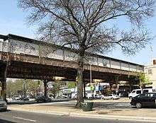
Woodhaven Boulevard is an elevated station on the BMT Jamaica Line of the New York City Subway, located in Woodhaven, Queens.[4] It is served by the J train at all times and the Z train during rush hours in the peak direction.[5]
Station layout
| P Platform level |
Side platform, doors will open on the right | |
| Southbound | ← ← | |
| Center track | → No track or roadbed | |
| Northbound | → → (Temporarily closed: 104th Street) | |
| Side platform, doors will open on the right | ||
| M | Mezzanine | Fare control, station agent |
| G | Street Level | Exit / Entrance |

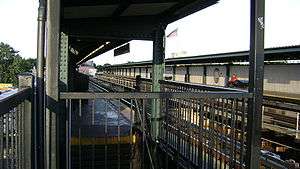
This elevated station opened on May 28, 1917,[1] and has two tracks and two side platforms with space for a center track.[6] Both platforms have beige windscreens and brown canopies with green roofs along the entire length except for a section at the west (railroad south) end. Here, there are only waist-high black steel fences.
This station has provisions built in its structure to convert it into an express station, if the center third track was to be installed. The other station on the line that had such provisions was the now demolished Sutphin Boulevard station.
The 1990 artwork here is called Five Points of Observation by Kathleen McCarthy. It affords a view of the street from the platforms and resembles a face when seen from the street. This artwork is also located on four other BMT Jamaica Line stations.[7][8]
Exits
This station has two entrances/exits, both of which are elevated station houses beneath the tracks that allow free transfers between directions. The main one is at the extreme west end and has a single staircase from each platform, turnstile bank, token booth, and two street stairs going down to either western corners of Woodhaven Boulevard and Jamaica Avenue.[9]
The other station house is un-staffed, containing just two HEET turnstiles, a staircase to each platform, and one staircase going down to the southwest corner of 95th Street and Jamaica Avenue.[9][4] The Queens-bound staircase's landing has an exit-only turnstile that allows passengers to exit the station without having to go through the station house.[9]
References
- 1 2
- "TO OPEN JAMAICA AV. LINE.; Nearly Two and a Half Miles Ready for Operation Tonight" (May 27, 1917). New York Times Company. May 27, 1917. p. 24. Retrieved April 21, 2015.
- "Jamaica Avenue 'L' is an Old Story Already" (PDF) (May 31, 1917). Leader Observer (Queens/Brooklyn, NY). May 31, 1917. p. 1. Retrieved April 20, 2015.
- Report of the Public Service Commission for the First District of the State of New York, Volume 1. New York State Public Service Commission. January 15, 1918. pp. 73, 81, 312–314. Retrieved April 20, 2015.
- ↑ "Station Developers' Information". Metropolitan Transportation Authority. Retrieved June 13, 2017.
- ↑ "Facts and Figures: Annual Subway Ridership 2012–2017". Metropolitan Transportation Authority. July 12, 2018. Retrieved July 12, 2018.
- 1 2 "Neighborhood Map Woodhaven City Line Cypress Hills Forest Hills Glendale Ozone Park" (PDF). mta.info. Metropolitan Transportation Authority. 2015. Retrieved October 2, 2016.
- ↑ "J/Z Subway Timetable, Effective June 24, 2018" (PDF). Metropolitan Transportation Authority. Retrieved June 24, 2018.
- ↑ Dougherty, Peter (2006) [2002]. Tracks of the New York City Subway 2006 (3rd ed.). Dougherty. OCLC 49777633 – via Google Books.
- ↑ "www.nycsubway.org: Artwork: Five Points of Observation (Kathleen McCarthy)". www.nycsubway.org. Retrieved 2016-10-02.
- ↑ "MTA - Arts & Design | NYCT Permanent Art". web.mta.info. Retrieved 2016-10-02.
- 1 2 3 "MTA Neighborhood Maps: Woodhaven" (PDF). mta.info. Metropolitan Transportation Authority. 2015. Retrieved 30 June 2015.
External links
| Wikimedia Commons has media related to Woodhaven Boulevard (BMT Jamaica Line). |
- nycsubway.org – BMT Jamaica Line: Woodhaven Boulevard
- Station Reporter — J Train
- The Subway Nut — Woodhaven Boulevard Pictures
- MTA's Arts For Transit — Woodhaven Boulevard (BMT Jamaica Line)
- Woodhaven Boulevard entrance from Google Maps Street View
- 95th Street entrance from Google Maps Street View
- Platforms from Google Maps Street View
| Jamaica Line |
|
|---|---|
| |