103rd Street (IRT Lexington Avenue Line)
103 Street | |||||||||||
|---|---|---|---|---|---|---|---|---|---|---|---|
|
| |||||||||||
 | |||||||||||
| Station statistics | |||||||||||
| Address |
East 103rd Street & Lexington Avenue New York, NY 10029 | ||||||||||
| Borough | Manhattan | ||||||||||
| Locale | East Harlem | ||||||||||
| Coordinates | 40°47′25″N 73°56′52″W / 40.79029°N 73.947687°WCoordinates: 40°47′25″N 73°56′52″W / 40.79029°N 73.947687°W | ||||||||||
| Division | A (IRT) | ||||||||||
| Line | IRT Lexington Avenue Line | ||||||||||
| Services |
4 6 | ||||||||||
| Transit connections |
| ||||||||||
| Structure | Underground | ||||||||||
| Platforms | 2 side platforms | ||||||||||
| Tracks | 4 | ||||||||||
| Other information | |||||||||||
| Opened | July 17, 1918 | ||||||||||
| Station code | 395[1] | ||||||||||
| Wireless service |
| ||||||||||
| Traffic | |||||||||||
| Passengers (2017) |
4,402,069[3] | ||||||||||
| Rank | 112 out of 425 | ||||||||||
| Station succession | |||||||||||
| Next north |
110th Street: 4 | ||||||||||
| Next south |
96th Street: 4 | ||||||||||
| |||||||||||
| |||||||||||
| |||||||||||


103rd Street is a local station on the IRT Lexington Avenue Line of the New York City Subway. Located at the intersection of Lexington Avenue and 103rd Street in East Harlem, it is served by the 6 train at all times, the <6> during weekdays in peak direction, and the 4 train during late nights.
Station layout
| G | Street Level | Exit/ Entrance |
| M | Mezzanine | Fare control, station agent |
| P Platform level |
Side platform, doors will open on the right | |
| Northbound local | ← ← | |
| Northbound express | ← | |
| Southbound express | → | |
| Southbound local | → → | |
| Side platform, doors will open on the right | ||
_by_David_Shankbone.jpg)
This underground station, which opened on July 17, 1918, has four tracks and two side platforms. The two center express tracks are used by the 4 and 5 trains during daytime hours. All other stations between Grand Central – 42nd Street and 125th Street on the line except 110th Street have the local tracks on an upper level and express ones on the lower level, with Emergency Exits provided at local stations for Emergency Egress.
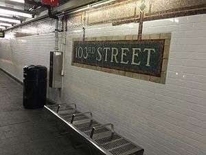
Both platforms have their original trim line, which has "103" tablets on it at regular intervals, and name tablets, which read "103RD STREET" in the original mosaic. Prior to the 1990 remodeling, mosaic tiles were used so as to depict the 103rd Street mosaic as a sign hanging down from a horizontal support beam above. These "signholders" were covered over in 1990. An emergency phone is present immediately to the south of the southbound local platform.
The Downtown/Brooklyn platform was renovated in 2015, with the placement of new white wall tiles, new floor tiles and benches. From January 26, 2016 to May 23rd, 2016, the Uptown/Bronx-bound platform was closed for renovation and was done in the same style as the Downtown/Brooklyn platform. This was completed about a month earlier than planned.[4]
The station's only entrance/exit is a mezzanine above the platforms and tracks near the south end. It has two staircases from each platform, a waiting area that can be used as a crossover, turnstile bank, token booth, and two street stairs going up to the southeast and southwest corners of 103rd Street and Lexington Avenue. The mezzanine has mosaics indicating uptown and downtown directions.
The 1990 ceramic artwork here is called Neo-Boriken by Nitza Tufiño.
Exits
Both exits serve both platforms.
| Exit location[5] | Exit type | Number of exits |
|---|---|---|
| SW corner of Lexington Avenue and 103rd Street | Staircase | 1 |
| SE corner of Lexington Avenue and 103rd Street | Staircase | 1 |
References
- ↑ "Station Developers' Information". Metropolitan Transportation Authority. Retrieved June 13, 2017.
- ↑ "NYC Subway Wireless – Active Stations". Transit Wireless Wifi. Retrieved May 18, 2016.
- ↑ "Facts and Figures: Annual Subway Ridership 2012–2017". Metropolitan Transportation Authority. July 12, 2018. Retrieved July 12, 2018.
- ↑ http://web.mta.info/nyct/service/planned_servChanges_46_Jan2015.htm
- ↑ "MTA Neighborhood Maps: Upper East Side" (PDF). mta.info. Metropolitan Transportation Authority. 2016. Retrieved December 30, 2016.
External links
| Wikimedia Commons has media related to 103rd Street (IRT Lexington Avenue Line). |
- nycsubway.org – IRT East Side Line: 103rd Street
- nycsubway.org — Neo-Boriken Artwork by Nitza Tufino (1990)
- Station Reporter — 4 Train
- Station Reporter — 6 Train
- MTA's Arts For Transit — 103rd Street (IRT Lexington Avenue Line)
- 103rd Street entrance from Google Maps Street View
- Platforms from Google Maps Street View
| Lexington Ave. Line |
|
|---|---|
| |