Wall Street (IRT Lexington Avenue Line)
Wall Street | |||||||||
|---|---|---|---|---|---|---|---|---|---|
|
| |||||||||
 Downtown | |||||||||
| Station statistics | |||||||||
| Address |
Wall Street & Broadway New York, NY 10006 | ||||||||
| Borough | Manhattan | ||||||||
| Locale | Financial District | ||||||||
| Coordinates | 40°42′28″N 74°00′42″W / 40.70771°N 74.011717°WCoordinates: 40°42′28″N 74°00′42″W / 40.70771°N 74.011717°W | ||||||||
| Division | A (IRT) | ||||||||
| Line | IRT Lexington Avenue Line | ||||||||
| Services |
4 5 | ||||||||
| Transit connections |
| ||||||||
| Structure | Underground | ||||||||
| Platforms | 2 side platforms | ||||||||
| Tracks | 2 | ||||||||
| Other information | |||||||||
| Opened | June 12, 1905 | ||||||||
| Station code | 413[1] | ||||||||
| Wireless service |
| ||||||||
| Traffic | |||||||||
| Passengers (2017) |
5,704,122[3] | ||||||||
| Rank | 78 out of 425 | ||||||||
| Station succession | |||||||||
| Next north |
Fulton Street: 4 | ||||||||
| Next south |
Bowling Green: 4 | ||||||||
| |||||||||
| |||||||||
| |||||||||
|
Wall Street Subway Station (IRT) | |||||||||
   | |||||||||
| Location | Under Broadway at Wall Street, New York, NY 10016 | ||||||||
| Coordinates | 40°42′27″N 74°0′44″W / 40.70750°N 74.01222°W | ||||||||
| Area | less than one acre | ||||||||
| Built | 1905 | ||||||||
| Architect | Parsons, William Barclay; Heins, George L., et al | ||||||||
| Architectural style | Beaux Arts | ||||||||
| MPS | New York City Subway System MPS | ||||||||
| NRHP reference # | 04001011[4] | ||||||||
| Added to NRHP | September 17, 2004 | ||||||||
Wall Street is a station on the IRT Lexington Avenue Line of the New York City Subway, located at the intersection of Broadway and Wall Street. It is served by the 4 train at all times and the 5 train at all times except late nights.
History
This station opened on June 12, 1905, as a one-stop extension of the original subway from Fulton Street.[5][6]
On January 6, 1994, Automated Fare Collection turnstiles went into service at this station, and at the Whitehall Street station.[7]
In 1995, as a result of service reductions, the MTA was considering permanently closing one of the two Wall Street stations, as well as two other stations citywide, due to their proximity to each other. Either the IRT Broadway–Seventh Avenue Line or the IRT Lexington Avenue Line station would have been closed.[8]
Station layout
| G | Street Level | Exit/ Entrance |
| B1 Platform level |
Side platform, doors will open on the right | |
| Northbound | ← ← | |
| Southbound | → → | |
| Side platform, doors will open on the right | ||
| B2 | Crossunder | Transfer between platforms, passageway to Broad Street |
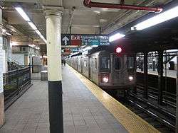
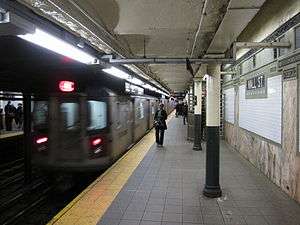
Wall Street is an underground, two-tracked station, with two side platforms that are slightly offset from one another.
The standard IRT name tablet mosaics are original as well as the fancy ceiling accents and the iron pillars. On the southbound platform is a wooden token booth and ticket chopper, wooden restroom doors on each side. The walls on the platforms are clad in pink stone at the bottom, followed by white tiles, the name of the station in white letters and blue mosaics, and decorated tiles at the top. The top part is decorated with tiles depicting vines or artistic depictions of a New Amsterdam stapled colonial house with the palisade wall in front of it, which gave today's Wall Street its name.
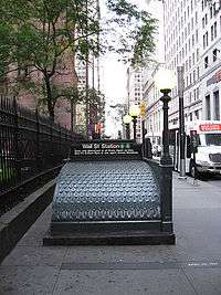
The entrances are covered with curved metal roofs painted green. The metal is sculpted with patterns made to resemble wood or leaves.
There is a crossunder about midway along the length of the platforms, and a lesser-used one at the north end.
Exits
There are three exit areas. On the south end, between Rector Street and Exchange Place, there are two exits to either side of Broadway, with the northbound exits on the east side and the southbound exits on the west side.[9] There are faux kiosks on the southbound side.
A complex underground passageway exists outside the fare control which connects to the Broad Street station on the BMT Nassau Street Line, and to the Wall Street station on the Brooklyn Branch of the IRT Broadway–Seventh Avenue Line. This passageway also leads to the Chase Manhattan Plaza and the old Equitable Building. The stations have a shared exit to the eastern corner of Cedar and Nassau Streets.[9]
On the north end on the southbound side only, there is an exit under the Trinity Building.[9] It has an opulent gold-colored banner proclaiming "SUBWAY ENTRANCE" atop the entrance, which is half a flight below ground. The exit also has a Subway restaurant outside fare control.[10]
Renovation
The original white tiles from the early 20th century were walled over with glossy dark blue tiles in the 1970s, with only the name of station allowed to stay. Similar remodeling work was done during that time with 51st Street station on the IRT Lexington Avenue Line, using beige tiles.
In 2006, a project to renovate/restore the station back to its original appearance began. As of May 2006, the blue tiles mentioned above had been removed and remnants of the original white tile-work exposed. The condition of the original tiles were fair to poor to completely missing. All missing tiles were refitted based on original models.
Image gallery
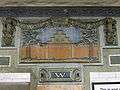 Depiction of the wall of New Amsterdam on a mosaic tile
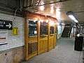 Old wooden ticket booth
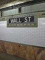 View of the wall, consisting of pink stone at the bottom, white tiles, the mosaic name of the station and further artful tiles
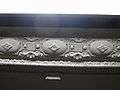 Decorated ceiling elements
References
- ↑ "Station Developers' Information". Metropolitan Transportation Authority. Retrieved June 13, 2017.
- ↑ "NYC Subway Wireless – Active Stations". Transit Wireless Wifi. Retrieved May 18, 2016.
- ↑ "Facts and Figures: Annual Subway Ridership 2012–2017". Metropolitan Transportation Authority. July 12, 2018. Retrieved July 12, 2018.
- ↑ National Park Service (2010-07-09). "National Register Information System". National Register of Historic Places. National Park Service.
- ↑ "SUBWAY TRAINS RUN AGAIN THIS MORNING; Through Service Promised for the rush-Hour Crowds. TUNNEL PUMPED OUT AT LAST Big Water Main That Burst Was an Old One, Pressed Into Service Again After a Five-Hour Watch" (PDF). Retrieved 2016-09-18.
- ↑ "SUBWAY TO WALL ST. OPEN IN TEN DAYS; And All the Way to the Bronx by July 1. WHOLE ROAD READY IN AUGUST As to the Air Therein, William Barclay Parsons Says It Is Pure and Can't Be Bettered" (PDF). Retrieved 2016-09-18.
- ↑ "About NYC Transit - History". 2002-10-19. Retrieved 2016-09-18.
- ↑ Perez-Pena, Richard (1995-02-25). "BOARD VOTES CUTS FOR CITY TRANSIT". The New York Times. Retrieved 2018-05-16.
- 1 2 3 "MTA Neighborhood Maps: Lower Manhattan" (PDF). mta.info. Metropolitan Transportation Authority. 2018. Retrieved October 1, 2018.
- ↑ "TRINITY BUILDING SUBWAY ENTRANCE, Financial District". Forgotten New York. 2015-11-26. Retrieved 2017-01-02.
Further reading
- Lee Stokey. Subway Ceramics : A History and Iconography. 1994. ISBN 978-0-9635486-1-0
External links
| Wikimedia Commons has media related to Wall Street (IRT Lexington Avenue Line). |
- nycsubway.org – IRT East Side Line: Wall Street
- Wall Street - Rector Street entrance from Google Maps Street View
- Platforms from Google Maps Street View
| Lexington Ave. Line |
|
|---|---|
| |
| Topics |   | |
|---|---|---|
| Lists by county |
| |
| Lists by city | ||
| Other lists | ||
| ||