Gun Hill Road (IRT White Plains Road Line)
Gun Hill Road | |||||||||
|---|---|---|---|---|---|---|---|---|---|
|
| |||||||||
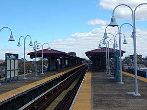 The Gun Hill Road station platform in April 2015. | |||||||||
| Station statistics | |||||||||
| Address |
East Gun Hill Road & White Plains Road Bronx, NY 10467 | ||||||||
| Borough | The Bronx | ||||||||
| Locale | Williamsbridge, Allerton | ||||||||
| Coordinates | 40°52′37″N 73°52′01″W / 40.877°N 73.867°WCoordinates: 40°52′37″N 73°52′01″W / 40.877°N 73.867°W | ||||||||
| Division | A (IRT) | ||||||||
| Line |
IRT White Plains Road Line IRT Third Avenue Line (formerly) | ||||||||
| Services |
2 5 | ||||||||
| Transit connections |
| ||||||||
| Structure | Elevated | ||||||||
| Levels | 2 (lower level abandoned) | ||||||||
| Platforms |
2 island platforms cross-platform interchange | ||||||||
| Tracks | 3 | ||||||||
| Other information | |||||||||
| Opened |
March 3, 1917 (upper level) October 4, 1920 (lower level) | ||||||||
| Closed | April 29, 1973 (lower level) | ||||||||
| Station code | 421[1] | ||||||||
| Accessible |
| ||||||||
| Traffic | |||||||||
| Passengers (2017) |
2,429,804[2] | ||||||||
| Rank | 203 out of 425 | ||||||||
| Station succession | |||||||||
| Next north |
Wakefield–241st Street (express): no regular service 219th Street (local): 2 | ||||||||
| Next south |
Burke Avenue (local): 2 East 180th Street (express): no regular service 210th Street–Williamsbridge (3rd Ave. local; demolished) Fordham Road–190th Street (3rd Ave. express; demolished) | ||||||||
|
| |||||||||
| Next |
233rd Street: 2 | ||||||||
| Next |
Pelham Parkway: 2 | ||||||||
| |||||||||
| |||||||||
| |||||||||


Gun Hill Road is an express station on the IRT White Plains Road Line of the New York City Subway. Located in the Bronx at the intersection of Gun Hill and White Plains Roads,[3] it is served by the 2 train at all times and by the 5 train during rush hours in the peak direction.
History
This station was opened along with the section of the IRT White Plains Road Line from East 177th Street–East Tremont Avenue to East 219th Street–White Plains Road on March 3, 1917, providing access to rapid transit service to the communities of Williamsbridge and Wakefield in the Bronx. Service on the new portion of the line was operated as a four-car shuttle from 177th Street due to the power conditions at the time.[4][5][6]
Station layout
| 2F Platforms |
Southbound local | ← ← |
| Island platform, doors will open on the left | ||
| Peak-direction express | → No regular service (No service: Wakefield–241st Street (north) or East 180th Street (south)) | |
| Island platform, doors will open on the left | ||
| Northbound local | → → | |
| 1F | Mezzanine | Fare control, station agent, former Third Avenue El platform |
| G | Street Level | Exit/ Entrance |
This station opened on March 3, 1917, as a bi-level station, for IRT White Plains Road Line subway service. The upper level has always been used and the lower level was used by the IRT Third Avenue Line from October 4, 1920,[7] to April 29, 1973. The upper level has three tracks and two island platforms, while the lower level had two tracks and one wide island platform. North of the station, the lower level tracks rose and joined, making a five track line for a short distance. From west to east, they were as follows: White Plains Road Line southbound local, Third Avenue Line southbound, White Plains Road Line center express, Third Avenue Line northbound, White Plains Road Line northbound local.[8]
Currently, only the two outer tracks are used. The center track is not normally used in revenue service.
Exit
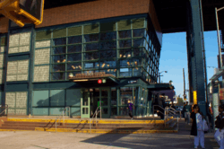
The station's only exit is at a street-level station house at the north side of Gun Hill Road in the median of White Plains Road. A refurbishing project in 2004–2006 removed the Third Avenue el level and upgraded the station with the new station house at street level. The original station house was one short block north at East 211th Street. New escalators and elevators now make this station ADA-accessible.[9]
References
- ↑ "Station Developers' Information". Metropolitan Transportation Authority. Retrieved June 13, 2017.
- ↑ "Facts and Figures: Annual Subway Ridership 2012–2017". Metropolitan Transportation Authority. July 12, 2018. Retrieved July 12, 2018.
- ↑ "Neighborhood Map Pelham Parkway Olinville Pelham Gardens Morris Park" (PDF). mta.info. Metropolitan Transportation Authority. 2015. Retrieved October 2, 2016.
- ↑ "Annual report. 1916-1917". HathiTrust. Interborough Rapid Transit Company. December 12, 2013. Retrieved September 5, 2016.
- ↑ "New Subway Line Opened: White Plains Extension is Now Running to 238th Street" (PDF). New York Times. Retrieved August 17, 2015.
- ↑ "WHITE PLAINS ROAD EXTENSION OF SUBWAY OPENED TO THE PUBLIC; New Branch, Which Runs from 177th to 219th Street, Gives the Williamsbridge and Wakefield Sections of the East Bronx Rapid Transit for the First Time" (PDF). The New York Times. March 4, 1917.
- ↑ Fischler, Stan (1997). The Subway: A Trip Through Time on New York's Rapid Transit. Flushing, NY: H&M Productions. pp. 245–249. ISBN 1-882608-19-4.
- ↑ Dougherty, Peter (2006) [2002]. Tracks of the New York City Subway 2006 (3rd ed.). Dougherty. OCLC 49777633 – via Google Books.
- ↑ "MTA Neighborhood Maps: Pelham Parkway" (PDF). mta.info. Metropolitan Transportation Authority. 2015. Retrieved July 20, 2016.
External links
| Wikimedia Commons has media related to Gun Hill Road (IRT White Plains Road Line). |
- nycsubway.org – IRT White Plains Road Line: Gun Hill Road
- nycsubway.org – Mi Sol, Mi Planeta, Mi Ciudad (My Sun, My Planet, My City): Artwork by Andrea Arroyo (2006)
- nycsubway.org – IRT 3rd Avenue El: Gun Hill Road
- nycsubway.org – IRT 3rd Avenue El:
- The Subway Nut — Gun Hill Road Pictures
- Station Reporter — 2 Train
- Station Reporter — 3rd Avenue Local
- MTA's Arts For Transit — Gun Hill Road (IRT White Plains Road Line)
- Gun Hill Road entrance from Google Maps Street View
- Platforms from Google Maps Street View
- Mezzanine from Google Maps Street View
| White Plains Rd. Line |
|
|---|---|
| |