Morris Park (IRT Dyre Avenue Line)
Morris Park | |||||||||||
|---|---|---|---|---|---|---|---|---|---|---|---|
|
| |||||||||||
 | |||||||||||
| Station statistics | |||||||||||
| Address |
Paulding Avenue & Esplanade Bronx, NY 10461 | ||||||||||
| Borough | The Bronx | ||||||||||
| Locale | Morris Park | ||||||||||
| Coordinates | 40°51′16″N 73°51′37″W / 40.854429°N 73.860397°WCoordinates: 40°51′16″N 73°51′37″W / 40.854429°N 73.860397°W | ||||||||||
| Division | A (IRT, formerly NYW&B) | ||||||||||
| Line | IRT Dyre Avenue Line | ||||||||||
| Services |
5 | ||||||||||
| Structure | Partially underground and partially on embankment | ||||||||||
| Platforms | 2 side platforms | ||||||||||
| Tracks | 4 (2 in regular service) | ||||||||||
| Other information | |||||||||||
| Opened |
May 29, 1912 (NYW&B station) May 15, 1941 (re-opened as a Subway station) | ||||||||||
| Station code | 446[1] | ||||||||||
| Traffic | |||||||||||
| Passengers (2017) |
685,577[2] | ||||||||||
| Rank | 389 out of 425 | ||||||||||
| Station succession | |||||||||||
| Next north |
Pelham Parkway: 5 | ||||||||||
| Next south |
East 180th Street: 5 | ||||||||||
| |||||||||||
| |||||||||||
| |||||||||||
|
Morris Park Station | |||||||||||
 | |||||||||||
  | |||||||||||
| Location | Under Esplanade Ave. at Bogart and Colden Ave. and Hone Ave., Bronx, New York | ||||||||||
| Coordinates | 40°51′16″N 73°51′37″W / 40.854429°N 73.860397°W | ||||||||||
| Area | less than one acre | ||||||||||
| Built | 1912 | ||||||||||
| Architect | Reed and Stem; Fellheimer & Long | ||||||||||
| Architectural style | Mission/Spanish Revival | ||||||||||
| MPS | New York City Subway System MPS | ||||||||||
| NRHP reference # | 05000677[3] | ||||||||||
| Added to NRHP | July 6, 2005 | ||||||||||

Morris Park is a station on the IRT Dyre Avenue Line of the New York City Subway served by the 5 train at all times. It is at Paulding Avenue and the Esplanade in Morris Park, Bronx.
History
The station was first placed in service in 1912 as part of the New York, Westchester and Boston Railroad, a subsidiary of the New York, New Haven and Hartford. The line was designed for the weight of the heaviest main line steam trains.
The emblem of the NYW&B, was the caduceus, a staff entwined with serpents that has served as a symbol of commerce since Classical times. It is cast into several locations of the concrete facade facing the Esplanade. The NYW&B offered frequent service between 138th Street in the South Bronx and White Plains and Port Chester in Westchester County. The White Plains and Port Chester branches diverged at Mount Vernon Junction near Columbus Avenue along the boundary between Mount Vernon and Pelham.
The two outer tracks at Morris Park were for trains that made local stops in the Bronx, and went to Port Chester. The two inner tracks were for express trains that made limited stops in The Bronx, and went to White Plains. The trains were powered by 11,000 volt 25 Hz alternating current supplied from overhead catenary. The cut-off stumps of the catenary bridges remain along the right of way and can be seen from the south ends of the platforms.
The NYW&B was doomed by the bankruptcy of its patron, the New Haven. Service ended in 1937.
A few years later, the portion in The Bronx became part of the New York City Transit System. Initial subway service was a shuttle (nicknamed "The Dinky") to the old NYW&B platforms at East 180th Street. In the late 1950s, the construction of a flying junction with the White Plains Road line allowed Dyre Avenue trains to enter the East 180th Street subway station and continue to Manhattan.
Around this period, the Morris Park platforms were extended towards the south to accommodate ten-car subway trains. This required reducing the height of the outboard plate girders of the bridge over Colden Avenue so that the bottoms of the platforms would be above the tops of the girders. The massive overdesign of the bridge allowed ample margin for trimming the girders.
On November 24, 1979, an R22 car, #7602, was involved in a rear-ending accident here.
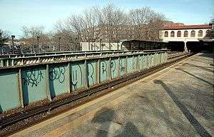
In the late 1990s, the original concrete exterior walls alongside the station platforms and the original roof that was supported on concrete columns and massive cantilevered timbers were replaced with steel bents supporting a clad metal wall system and a corrugated metal roof deck.
Station layout
| 4F | Ground Level | Ground Level (north of station) |
| 3F Platform level |
Side platform, doors will open on the right | |
| Northbound local | ← | |
| Northbound express | No passenger service | |
| Southbound express | No regular service | |
| Southbound local | → | |
| Side platform, doors will open on the right | ||
| 2F | Mezzanine | to entrances/exits, station agent, MetroCard vending machines |
| 1F | Ground Level | Entrances/Exits, Ground Level (south of station) |
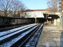
The station has two side platforms with four tracks (two center express tracks formerly used by the New York, Westchester and Boston Railway) and is partially underground and partially on an embankment. The underground portion is at the south end of a 4,000-foot (1,200 m) long, four-track tunnel under the Bronx and Pelham Parkway. This tunnel includes a four-track underground station called Pelham Parkway about half mile from Morris Park. The heavy construction and high clearances greatly exceed the size and weight requirements of IRT subway cars.
From the 1990s until the early 2000s the platform walls had a red and blue skyline design, before being painted beige. The station was listed on the National Register of Historic Places on July 6, 2005.
Exit
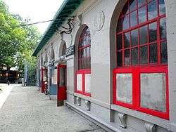
The station's only entrance/exit is a head house at the southwest corner of Esplanade and Paulding Avenue.[4] The head house is notable for its graceful Spanish Mission style architecture and robust reinforced concrete construction. The handsome exterior, with its tall arched windows and tiled roof, has been restored to good condition. It was designed by Alfred T. Fellheimer, who was the lead architect for Grand Central Terminal.[5]
Formerly there were two other entrances to the station. A lower level entrance with a waiting room, now bricked over, was located near the foot of Lydig Avenue. The other entrance was a street level entrance that led from Paulding Avenue onto the southbound platform; it is now filled with concrete.
References
- ↑ "Station Developers' Information". Metropolitan Transportation Authority. Retrieved June 13, 2017.
- ↑ "Facts and Figures: Annual Subway Ridership 2012–2017". Metropolitan Transportation Authority. July 12, 2018. Retrieved July 12, 2018.
- ↑ National Park Service (2009-03-13). "National Register Information System". National Register of Historic Places. National Park Service.
- ↑ "MTA Neighborhood Maps: Pelham Parkway" (PDF). mta.info. Metropolitan Transportation Authority. 2015. Retrieved July 20, 2016.
- ↑ White, Norval; Willensky, Elliot (June 2000). AIA Guide to New York City (4th ed.). New York: Three Rivers Press. ISBN 0-8129-3107-6.
External links
| Wikimedia Commons has media related to Morris Park (IRT Dyre Avenue Line). |
- nycsubway.org – IRT White Plains Road Line: Morris Park
- Station Reporter — 5 Train
- The Subway Nut — Morris Park Pictures
- Stairway on Paulding Avenue leading to the entrance from Google Maps Street View
- Station house from Google Maps Street View
- Platforms from Google Maps Street View
| Preceding station | New York, Westchester and Boston Railway | Following station | ||
|---|---|---|---|---|
| Former services | ||||
| East 180th Street | Main Line | Pelham Parkway | ||
Express | |
|---|---|
| |
| Dyre Ave. Line | |
|---|---|
| |
| Topics |   | |
|---|---|---|
| Lists by county |
| |
| Lists by city | ||
| Other lists | ||
| ||