Rector Street (IRT Broadway–Seventh Avenue Line)
Rector Street | |||||||||
|---|---|---|---|---|---|---|---|---|---|
|
| |||||||||
 Uptown platform | |||||||||
| Station statistics | |||||||||
| Address |
Rector Street & Greenwich Street New York, NY 10006 | ||||||||
| Borough | Manhattan | ||||||||
| Locale | Financial District | ||||||||
| Coordinates | 40°42′29″N 74°00′47″W / 40.708°N 74.013°WCoordinates: 40°42′29″N 74°00′47″W / 40.708°N 74.013°W | ||||||||
| Division | A (IRT) | ||||||||
| Line | IRT Broadway–Seventh Avenue Line | ||||||||
| Services |
1 | ||||||||
| Transit connections |
| ||||||||
| Structure | Underground | ||||||||
| Platforms | 2 side platforms | ||||||||
| Tracks | 2 | ||||||||
| Other information | |||||||||
| Opened | July 1, 1918 | ||||||||
| Closed | September 11, 2001 | ||||||||
| Rebuilt | September 15, 2002 | ||||||||
| Station code | 329[1] | ||||||||
| Wireless service |
| ||||||||
| Traffic | |||||||||
| Passengers (2017) |
2,861,772[3] | ||||||||
| Rank | 181 out of 425 | ||||||||
| Station succession | |||||||||
| Next north |
WTC Cortlandt: 1 | ||||||||
| Next south |
South Ferry: 1 South Ferry loops: no service | ||||||||
| |||||||||
| |||||||||
| |||||||||


Rector Street is a station on the IRT Broadway–Seventh Avenue Line of the New York City Subway. Located at the intersection of Rector Street and Greenwich Street in Lower Manhattan, it is served by the 1 train at all times.
History
A shuttle along the IRT Broadway–Seventh Avenue Line, splitting from the original line at Times Square–42nd Street and going south to 34th Street–Penn Station, had opened in 1917.[4] The shuttle line was extended south to South Ferry on July 1, 1918, with Rector Street being one of the stops along the South Ferry segment of the new extension. A shorter shuttle also ran from Chambers Street to Wall Street.[5] A new "H" system was implemented on August 1, 1918, and all trains on the Broadway–Seventh Avenue Line north of Times Square were rerouted to South Ferry or Brooklyn via the new extension, while the old IRT line via 42nd Street became the modern-day 42nd Street Shuttle.[6]
After the September 11, 2001 attacks, the subway tunnels around Cortlandt Street collapsed, and the line was closed temporarily. About 1,000 feet (300 m) of tunnels and trackage, including 575 feet (175 m) of totally destroyed tunnels and tracks in the vicinity of the World Trade Center site, were entirely rebuilt.[7] The station reopened on September 15, 2002.[8] During the intervening period, the station was renovated.
Due to water damage to South Ferry caused by Hurricane Sandy, all 1 trains terminated at this station until April 4, 2013, when the former South Ferry Loop terminal station reopened.[9]
Station layout
| G | Street level | Exit |
| P Platform level |
Side platform, doors open on the right | |
| Northbound | ← | |
| Southbound | → No service: South Ferry loops | |
| Side platform, doors open on the right | ||

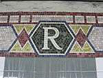
This underground station has two tracks and two side platforms. Each platform has mosaic trim line and name tablets of mostly green and brown. The tiles are painted light green below the "R" tablets.
Exits
This station has five fare control areas and there is no crossover between the uptown and downtown sides. On the northern end of the downtown platform, there are two High Entry/Exit Turnstiles leading to one street stair that goes up to the northwest corner of Rector and Greenwich Streets coming from two high entrance turnstiles directly on the platform. In the middle of the platform, two staircases lead up to a tiny intermediate level where a single exit-only turnstile leads to a staircase that goes up midblock on Greenwich Street between Rector and Edgar Streets. The last fare control area for this side at the south end has HEET turnstiles leading to a single staircase that goes up to just south of Edgar Street in a plaza where Greenwich Street ends at the foot of the Brooklyn–Battery Tunnel.[10]
Directly across the street from this area, there are two street stairs that lead down to two HEET turnstiles on the uptown platform. A single staircase at the northern end of this platform leads to the tiny, full-time mezzanine. It has a turnstile bank, token booth, and one street stair that leads to the north corner of Rector and Greenwich Streets.[10]
References
- ↑ "Station Developers' Information". Metropolitan Transportation Authority. Retrieved June 13, 2017.
- ↑ "NYC Subway Wireless – Active Stations". Transit Wireless Wifi. Retrieved May 18, 2016.
- ↑ "Facts and Figures: Annual Subway Ridership 2012–2017". Metropolitan Transportation Authority. July 12, 2018. Retrieved July 12, 2018.
- ↑ "Three New Links of the Dual Subway System Opened, Including a Shuttle Service from Times Square to Thirty-Fourth Street — Service on the Jerome Avenue Branch From 149th Street North to About 225th Street Began Yesterday Afternoon — The Event Celebrated by Bronx Citizens and Property Owners — The Seventh Avenue Connection Opened This Morning" (PDF). The New York Times. June 3, 1917. p. 1. Retrieved November 6, 2016.
- ↑ "Open New Subway to Regular Traffic — First Train on Seventh Avenue Line Carries Mayor and Other Officials — To Serve Lower West Side — Whitney Predicts an Awakening of the District — New Extensions of Elevated Railroad Service" (PDF). The New York Times. July 2, 1918. p. 11. Retrieved November 6, 2016.
- ↑ "Open New Subway Lines to Traffic; Called a Triumph — Great H System Put in Operation Marks an Era in Railroad Construction — No Hitch in the Plans — But Public Gropes Blindly to Find the Way in Maze of New Stations — Thousands Go Astray — Leaders in City's Life Hail Accomplishment of Great Task at Meeting at the Astor" (PDF). The New York Times. August 2, 1918. p. 1. Retrieved November 6, 2016.
- ↑ Kennedy, Randy (January 4, 2002). "Subway Line In Attack May Reopen Much Earlier". The New York Times. New York City: The New York Times. Retrieved April 17, 2014.
- ↑ Kennedy, Randy (September 17, 2002). "Tunnel Vision; With Station's Reopening, Even Commuters Smile". The New York Times. New York City: The New York Times. Retrieved October 6, 2007.
- ↑ "Archived copy". Archived from the original on 2013-12-16. Retrieved 2013-05-01.
- 1 2 "MTA Neighborhood Maps: Lower Manhattan" (PDF). mta.info. Metropolitan Transportation Authority. 2015. Retrieved August 21, 2015.
External links


- nycsubway.org – IRT West Side Line: Rector Street
- Station Reporter – 1 Train
- Rector Street entrance from Google Maps Street View
- South entrance near Brooklyn Battery Tunnel from Google Maps Street View
- Platforms from Google Maps Street View