104th Street (BMT Jamaica Line)
104 Street | |||||||||||
|---|---|---|---|---|---|---|---|---|---|---|---|
|
| |||||||||||
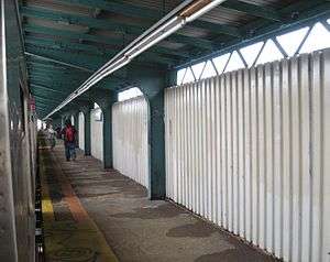 Northbound platform | |||||||||||
| Station statistics | |||||||||||
| Address |
104th Street & Jamaica Avenue Queens, NY 11418 | ||||||||||
| Borough | Queens | ||||||||||
| Locale | Richmond Hill | ||||||||||
| Coordinates | 40°41′43″N 73°50′36″W / 40.695184°N 73.843231°WCoordinates: 40°41′43″N 73°50′36″W / 40.695184°N 73.843231°W | ||||||||||
| Division | B (BMT) | ||||||||||
| Line | BMT Jamaica Line | ||||||||||
| Services |
J Z | ||||||||||
| Transit connections |
| ||||||||||
| Structure | Elevated | ||||||||||
| Platforms | 2 side platforms | ||||||||||
| Tracks | 2 | ||||||||||
| Other information | |||||||||||
| Opened | May 28, 1917[1][2][3] | ||||||||||
| Station code | 082[4] | ||||||||||
| Former/other names |
102nd Street 102nd–104th Streets 104th–102nd Streets | ||||||||||
| Traffic | |||||||||||
| Passengers (2017) |
502,541[5] | ||||||||||
| Rank | 406 out of 425 | ||||||||||
| Station succession | |||||||||||
| Next north |
111th Street: J (Z | ||||||||||
| Next south |
Woodhaven Boulevard: J | ||||||||||
| |||||||||||
| |||||||||||
| |||||||||||


104th Street is a skip-stop station on the BMT Jamaica Line of the New York City Subway, located on Jamaica Avenue between 102nd and 104th Streets in Richmond Hill, Queens.[6] It is served by the Z train during rush hours in the peak direction, and the J at all other times in the southbound direction only. Northbound trains will not stop here until late 2018 due to platform construction.[7]
Station layout
| P Platform level |
Side platform, doors will open on the right | |
| Southbound | ← ← | |
| Center trackway | → No track or roadbed | |
| Northbound | → → Temporarily closed: 121st Street | |
| Side platform, temporarily closed for construction | ||
| M | Mezzanine | Fare control, station agent |
| G | Street Level | Exit / Entrance |
This elevated station opened on May 28, 1917[1][2][3] under the Brooklyn Union Elevated Railroad, an affiliate of the Brooklyn Rapid Transit Company. The former Brooklyn Manor station on the LIRR's defunct Rockaway Beach Branch, which was closed in 1962, is two blocks to the west and could be an available transfer if the Rockaway Beach Branch is reopened for train service.

Until 1966, this station was known as 102nd Street. It was then given the dual name of 102nd–104th Streets.[8] As of 2011, station signage and the official map give the station name as 104th Street.[9]
This station has two tracks and two side platforms, but there is room for a center track.[10] Both platforms have beige windscreens and brown canopies with green frames and support columns for their entire length except for a small section at either end. Here, there are only waist-high steel fences with lampposts. The station signs are in the standard black name plate with white lettering.[11]
The 1990 artwork is called Five Points of Observation by Kathleen McCarthy. It is made of copper mesh, allowing a view of the streets from the platforms, and resembles a human face when viewed from the street. It is found on five other stations on the BMT Jamaica Line.[12][13]
The Manhattan-bound platform of this station was closed for renovation until April 11, 2018.[14] The Jamaica Center-bound platform of the station closed on July 23, 2018 for repairs, and will reopen in January 2019.[15]
Exits
This station has one active station house beneath the platforms near the east end. A single staircase from each platform goes down to a waiting area/crossunder, where a turnstile bank provides access to and from the station.[8] Outside fare control, there is a token booth and two staircases to the street. One faces south and goes down to the southeast corner of 104th Street and Jamaica Avenue while the other faces west and goes down to the north side of Jamaica Avenue near the northwest corner of 104th Street.[6][16] The station house has concrete flooring and windscreens going halfway up the platform stairs.
This station formerly had another mezzanine at 102nd Street. The station house and stairs to the street have been removed.[8]
References
- 1 2 "TO OPEN JAMAICA AV. LINE.; Nearly Two and a Half Miles Ready for Operation Tonight" (May 27, 1917). New York Times Company. May 27, 1917. p. 24. Retrieved 2016-04-19.
- 1 2 "Jamaica Avenue 'L' is an Old Story Already" (PDF) (May 31, 1917). Leader Observer (Queens/Brooklyn, NY). May 31, 1917. p. 1. Retrieved 2016-04-19.
- 1 2 Report of the Public Service Commission for the First District of the State of New York, Volume 1. New York State Public Service Commission. January 15, 1918. pp. 73, 81, 312–314. Retrieved 2016-04-19.
- ↑ "Station Developers' Information". Metropolitan Transportation Authority. Retrieved June 13, 2017.
- ↑ "Facts and Figures: Annual Subway Ridership 2012–2017". Metropolitan Transportation Authority. July 12, 2018. Retrieved July 12, 2018.
- 1 2 "Neighborhood Map Woodhaven City Line Cypress Hills Forest Hills Glendale Ozone Park" (PDF). mta.info. Metropolitan Transportation Authority. 2015. Retrieved October 2, 2016.
- ↑ "J/Z Subway Timetable, Effective June 24, 2018" (PDF). Metropolitan Transportation Authority. Retrieved June 24, 2018.
- 1 2 3 "www.nycsubway.org: BMT Nassau Street-Jamaica Line". www.nycsubway.org. Retrieved 2016-02-18.
- ↑ "Subway Map" (PDF). Metropolitan Transportation Authority. January 18, 2018. Retrieved January 18, 2018.
- ↑ Dougherty, Peter (2006) [2002]. Tracks of the New York City Subway 2006 (3rd ed.). Dougherty. OCLC 49777633 – via Google Books.
- ↑ Cox, Jeremiah. "104 Street (J, Z Skip-Stop) - The SubwayNut". www.subwaynut.com. Retrieved 2016-02-18.
- ↑ "MTA - Arts for Transit | NYCT Permanent Art". web.mta.info. Retrieved 2016-02-18.
- ↑ "www.nycsubway.org: Artwork: Five Points of Observation (Kathleen McCarthy)". www.nycsubway.org. Retrieved 2016-10-02.
- ↑ "Planned Service Changes for: Friday, April 13, 2018". mta.info. Metropolitan Transportation Authority. Retrieved April 13, 2018.
- ↑ "Planned Service Changes for: Monday, July 23, 2018". mta.info. Metropolitan Transportation Authority. Retrieved July 23, 2018.
- ↑ "MTA Neighborhood Maps: Kew Gardens" (PDF). mta.info. Metropolitan Transportation Authority. 2015. Retrieved 30 June 2015.
External links
| Jamaica Line |
|
|---|---|
| |