Cypress Hills (BMT Jamaica Line)
Cypress Hills | |||||||||||
|---|---|---|---|---|---|---|---|---|---|---|---|
|
| |||||||||||
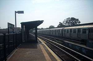 The station, middle trackbed and a R42 train stopped. | |||||||||||
| Station statistics | |||||||||||
| Address |
Hemlock Street & Jamaica Avenue Brooklyn, NY 11208 | ||||||||||
| Borough | Brooklyn | ||||||||||
| Locale | Cypress Hills | ||||||||||
| Coordinates | 40°41′23″N 73°52′23″W / 40.68972°N 73.87306°WCoordinates: 40°41′23″N 73°52′23″W / 40.68972°N 73.87306°W | ||||||||||
| Division | B (BMT) | ||||||||||
| Line |
BMT Jamaica Line BMT Lexington Avenue Line (formerly) | ||||||||||
| Services |
J | ||||||||||
| Transit connections |
| ||||||||||
| Structure | Elevated | ||||||||||
| Platforms | 2 side platforms | ||||||||||
| Tracks | 2 | ||||||||||
| Other information | |||||||||||
| Opened | May 30, 1893[1][2] | ||||||||||
| Rebuilt | May 28, 1917[2] | ||||||||||
| Station code | 086[3] | ||||||||||
| Former/other names |
Cypress Hills Cemetery City Line | ||||||||||
| Traffic | |||||||||||
| Passengers (2017) |
435,855[4] | ||||||||||
| Rank | 410 out of 425 | ||||||||||
| Station succession | |||||||||||
| Next north |
75th Street – Elderts Lane: J (J | ||||||||||
| Next south |
Crescent Street: J | ||||||||||
| |||||||||||
| |||||||||||
| |||||||||||


Cypress Hills is a skip-stop station on the BMT Jamaica Line of the New York City Subway, located on Jamaica Avenue in the Cypress Hills neighborhood of northeastern Brooklyn. It is served by the J train at all times. The Z train skips this station when it operates.
Station layout
| P Platform level |
Side platform, doors will open on the right | |
| Southbound | ← ← | |
| Center track | → No track or roadbed | |
| Northbound | → → | |
| Side platform, doors will open on the right | ||
| M | Mezzanine | Fare control, station agent |
| G | Street Level | Exit/ Entrance |
This is the northernmost station in Brooklyn on the BMT Jamaica Line. The next stop, 75th Street – Elderts Lane, is in Queens.
The original Cypress Hills station, opened on May 30, 1893,[1] had two tracks and one island platform and was located along Crescent Street, reaching the cemetery. This station was the terminal for both the Jamaica Line and the BMT Lexington Avenue Line when it opened.[5] It formerly had an island platform and stub-end located directly along Crescent Street just south of Jamaica Avenue that can still be seen approaching the cemetery east of the station.[1] The rebuilt station was constructed under the Dual Contracts and was opened on May 28, 1917.[2] The rebuilt station has two tracks and two side platforms. The removal of the island platform resulted in a space between the tracks. This space would allow for an express third track, but one was never built. Both platforms have beige windscreens and green canopies with brown roofs that run along the entire length. Lexington Avenue Line service terminated in October 1950, but Jamaica Line trains continued to serve the station.
Just west of this station are two sharp curves that trains must navigate at less than 15 mph. For this reason, a train must take more time to transverse this section than other sections of the line.
The 1990 artwork here is called Five Points of Observation, by Kathleen McCarthy. It affords a view of the street from the platforms and resembles a face when seen from the street. This artwork is also located in four other stations on the Jamaica Line.
Exits
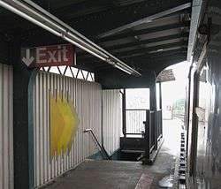
The station's main entrance is at the south end. A single staircase from each platform leads to an elevated station house beneath the tracks. Inside are three turnstiles and a token booth. Outside of fare control, two street stairs lead to the corners of Hemlock and Crescent Streets.[6]
On the north end of the northbound platform, a single staircase leads to a landing outside of a now closed station house, where a single exit-only turnstile provides exit from the system. A street stair perpendicular to the line leads to Autumn Avenue, which ends at Jamaica Avenue.[6]
References
- 1 2 3 "Trains Running This Morning". Brooklyn Daily Eagle. Brooklyn, NY. 30 May 1893. p. 10.
- 1 2 3
- "TO OPEN JAMAICA AV. LINE.; Nearly Two and a Half Miles Ready for Operation Tonight" (May 27, 1917). New York Times Company. May 27, 1917. p. 24. Retrieved April 21, 2015.
- "Jamaica Avenue 'L' is an Old Story Already" (PDF) (May 31, 1917). Leader Observer (Queens/Brooklyn, NY). May 31, 1917. p. 1. Retrieved April 20, 2015.
- Report of the Public Service Commission for the First District of the State of New York, Volume 1. New York State Public Service Commission. January 15, 1918. pp. 73, 81, 312–314. Retrieved April 20, 2015.
- ↑ "Station Developers' Information". Metropolitan Transportation Authority. Retrieved June 13, 2017.
- ↑ "Facts and Figures: Annual Subway Ridership 2012–2017". Metropolitan Transportation Authority. July 12, 2018. Retrieved July 12, 2018.
- ↑ http://www.nycsubway.org/perl/show?113358
- 1 2
- "MTA Neighborhood Maps: East New York" (PDF). mta.info. Metropolitan Transportation Authority. 2015. Retrieved 19 July 2015.
- "MTA Neighborhood Map: Woodhaven" (PDF). mta.info. Metropolitan Transportation Authority. 2015. Retrieved 22 July 2015.
External links
| Wikimedia Commons has media related to Cypress Hills (BMT Jamaica Line). |
- nycsubway.org – BMT Jamaica Line: Cypress Hills
- Station Reporter — J Train
- The Subway Nut — Cypress Hills Pictures
- MTA's Arts For Transit — Cypress Hills (BMT Jamaica Line)
- Crescent Street and Hemlock Street entrance from Google Maps Street View
- Autumn Avenue entrance from Google Maps Street View
- Platforms from Google Maps Street View
| |
| |
| Jamaica Line |
|
|---|---|
| |