Bastrop County, Texas
| Bastrop County, Texas | |
|---|---|
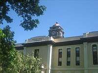
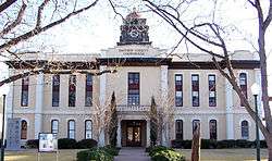 The Bastrop County Courthouse in Bastrop is designed in classical revival style. Built in 1883, the Courthouse and Jail Complex were listed in the National Register of Historic Places on November 20, 1975. | |
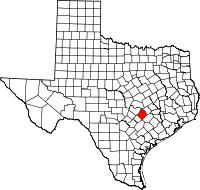 Location in the U.S. state of Texas | |
 Texas's location in the U.S. | |
| Founded | 1837 |
| Named for | Felipe Enrique Neri, Baron de Bastrop |
| Seat | Bastrop |
| Largest city | Elgin |
| Area | |
| • Total | 896 sq mi (2,321 km2) |
| • Land | 888 sq mi (2,300 km2) |
| • Water | 7.4 sq mi (19 km2), 0.8% |
| Population | |
| • (2010) | 74,141 |
| • Density | 84/sq mi (32/km2) |
| Congressional districts | 10th, 17th, 27th |
| Time zone | Central: UTC−6/−5 |
| Website |
www |
Bastrop County is a county in the U.S. state of Texas. As of the 2010 census, the population was 74,171.[1] Its county seat is Bastrop.[2] The county was created in 1834 as a municipality of Mexico and organized as a county in 1837.[3][4] It is named for Felipe Enrique Neri, Baron de Bastrop, an early Dutch settler who helped Stephen F. Austin obtain land grants in Texas.
Bastrop County is included in the Austin-Round Rock, TX metropolitan statistical area.
In September 2011, Bastrop County suffered the most destructive wildfire in Texas history, which destroyed over 1,600 homes.
Boundary changes
From January 8, 1836 to December 13, 1837, the Municipality and County of Mina consisted of parts of present-day Mason, Kimble, Llano, Burnet, Williamson, Gillespie, Blanco, Comal, Hays, Travis, Caldwell, Bastrop, Lee, Gonzales, Fayette, Washington, and Lavaca counties. On December 14, 1837, the Second Congress of the Republic of Texas passed legislation changing the geographical limits, creating Fayette County, removing Gonzales and Caldwell Counties from the boundaries and, five months later, added parts of Kimble and Comal Counties. On December 18, 1837, Sam Houston signed an act incorporating the town of Mina and, on the same day, changing the name of the county and town of Mina to Bastrop. May 24, 1838 to January 24, 1840, shows the borders of Bastrop County to contain parts of present-day Blanco, Burnet, Williamson, Travis, Hays, Comal, Caldwell, Bastrop, Lee, Gonzales and Fayette counties. From January 25, 1840 to January 25, 1850 the border changed to almost its present size with a small portion of Lee, Williamson, Caldwell, Gonzales and Fayette counties included.[5]
Geography
According to the U.S. Census Bureau, the county has a total area of 896 square miles (2,320 km2), of which 888 square miles (2,300 km2) is land and 7.4 square miles (19 km2) (0.8%) is water.[6]
Adjacent counties
- Williamson County (north)
- Lee County (northeast)
- Fayette County (southeast)
- Caldwell County (southwest)
- Travis County (northwest)
Demographics
| Historical population | |||
|---|---|---|---|
| Census | Pop. | %± | |
| 1850 | 3,099 | — | |
| 1860 | 7,006 | 126.1% | |
| 1870 | 12,209 | 74.3% | |
| 1880 | 17,215 | 41.0% | |
| 1890 | 20,736 | 20.5% | |
| 1900 | 26,845 | 29.5% | |
| 1910 | 25,344 | −5.6% | |
| 1920 | 26,649 | 5.1% | |
| 1930 | 23,888 | −10.4% | |
| 1940 | 21,610 | −9.5% | |
| 1950 | 19,622 | −9.2% | |
| 1960 | 16,925 | −13.7% | |
| 1970 | 17,297 | 2.2% | |
| 1980 | 24,726 | 42.9% | |
| 1990 | 38,263 | 54.7% | |
| 2000 | 57,733 | 50.9% | |
| 2010 | 74,171 | 28.5% | |
| Est. 2017 | 84,761 | [7] | 14.3% |
| U.S. Decennial Census[8] 1850–2010[9] 2010–2014[1] | |||
As of the census[10] of 2000, there were 57,733 people, 20,097 households, and 14,771 families residing in the county. The population density was 65 people per square mile (25/km²). There were 22,254 housing units at an average density of 25 per square mile (10/km²). The racial makeup of the county was 80.24% White, 8.79% Black or African American, 0.70% Native American, 0.46% Asian, 0.06% Pacific Islander, 7.60% from other races, and 2.15% from two or more races. 23.98% of the population were Hispanic or Latino of any race.
There were 20,097 households out of which 35.90% had children under the age of 18 living with them, 58.50% were married couples living together, 10.50% had a female householder with no husband present, and 26.50% were non-families. 21.50% of all households were made up of individuals and 7.50% had someone living alone who was 65 years of age or older. The average household size was 2.77 and the average family size was 3.23. As of the 2010 census, there were about 7.8 same-sex couples per 1,000 households in the county.[11]
In the county, the population was spread out with 28.00% under the age of 18, 7.60% from 18 to 24, 31.30% from 25 to 44, 22.90% from 45 to 64, and 10.30% who were 65 years of age or older. The median age was 35 years. For every 100 females there were 105.50 males. For every 100 females age 18 and over, there were 104.80 males.
The median income for a household in the county was $43,578, and the median income for a family was $49,456. Males had a median income of $32,843 versus $25,536 for females. The per capita income for the county was $18,146. About 8.40% of families and 11.60% of the population were below the poverty line, including 15.40% of those under age 18 and 13.30% of those age 65 or over.
Historical research
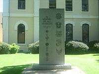
Bastrop County has several societies and associations dedicated to preserving historical information and sites.
Education
The following school districts serve Bastrop County:
Transportation
As of 2010 Central Texas Airport is under development in Bastrop County.[12]
Major highways
Recreational facilities
Communities
Cities
- Bastrop (county seat)
- Elgin (partly in Travis County)
- Mustang Ridge (mostly in Travis County and a small part in Caldwell County)
- Smithville
Census-designated places
Unincorporated communities
In popular culture
Several Hollywood feature films and notable independent films have used locations in Bastrop County.
Politics
| Year | Republican | Democratic | Third parties |
|---|---|---|---|
| 2016 | 57.0% 16,328 | 36.9% 10,569 | 6.2% 1,768 |
| 2012 | 57.3% 14,033 | 40.3% 9,864 | 2.4% 584 |
| 2008 | 53.0% 13,817 | 44.8% 11,687 | 2.1% 558 |
| 2004 | 56.7% 13,290 | 41.8% 9,794 | 1.5% 357 |
| 2000 | 56.3% 10,310 | 38.1% 6,973 | 5.6% 1,025 |
| 1996 | 43.4% 6,323 | 46.4% 6,773 | 10.2% 1,489 |
| 1992 | 34.4% 4,980 | 43.2% 6,252 | 22.4% 3,242 |
| 1988 | 42.5% 5,991 | 56.8% 8,004 | 0.7% 97 |
| 1984 | 57.4% 6,439 | 42.3% 4,744 | 0.3% 38 |
| 1980 | 43.1% 3,768 | 53.9% 4,716 | 3.0% 264 |
| 1976 | 33.1% 2,383 | 66.5% 4,788 | 0.5% 33 |
| 1972 | 61.8% 3,097 | 38.0% 1,906 | 0.1% 7 |
| 1968 | 28.4% 1,455 | 52.5% 2,687 | 19.1% 975 |
| 1964 | 22.4% 1,130 | 77.5% 3,912 | 0.1% 7 |
| 1960 | 29.6% 1,208 | 70.3% 2,866 | 0.2% 6 |
| 1956 | 37.9% 1,531 | 61.9% 2,504 | 0.3% 10 |
| 1952 | 32.8% 1,540 | 67.1% 3,148 | 0.1% 6 |
| 1948 | 13.7% 443 | 77.8% 2,518 | 8.5% 276 |
| 1944 | 11.7% 385 | 79.2% 2,604 | 9.1% 300 |
| 1940 | 16.8% 502 | 83.2% 2,492 | 0.1% 2 |
| 1936 | 7.6% 198 | 92.0% 2,395 | 0.4% 9 |
| 1932 | 5.5% 180 | 94.4% 3,077 | 0.1% 2 |
| 1928 | 35.7% 850 | 64.4% 1,534 | |
| 1924 | 14.3% 494 | 78.5% 2,711 | 7.2% 247 |
| 1920 | 22.4% 484 | 50.2% 1,088 | 27.4% 594 |
| 1916 | 28.8% 550 | 69.9% 1,335 | 1.3% 24 |
| 1912 | 15.3% 216 | 72.3% 1,021 | 12.4% 175 |
See also
References
- 1 2 "State & County QuickFacts". United States Census Bureau. Archived from the original on July 6, 2011. Retrieved December 8, 2013.
- ↑ "Find a County". National Association of Counties. Archived from the original on 2012-07-12. Retrieved 2011-06-07.
- ↑ "Texas: Individual County Chronologies". Texas Atlas of Historical County Boundaries. The Newberry Library. 2008. Archived from the original on May 13, 2015. Retrieved May 28, 2015.
- ↑ "Bastrop County". Texas Almanac. Texas State Historical Association. Archived from the original on June 18, 2015. Retrieved June 23, 2015.
- ↑ "TxGenWeb". Archived from the original on 3 February 2011. Retrieved 6 March 2011.
- ↑ "2010 Census Gazetteer Files". United States Census Bureau. August 22, 2012. Archived from the original on April 19, 2015. Retrieved April 19, 2015.
- ↑ "Population and Housing Unit Estimates". Archived from the original on May 4, 2018. Retrieved June 9, 2017.
- ↑ "U.S. Decennial Census". United States Census Bureau. Archived from the original on May 12, 2015. Retrieved April 19, 2015.
- ↑ "Texas Almanac: Population History of Counties from 1850–2010" (PDF). Texas Almanac. Archived (PDF) from the original on February 26, 2015. Retrieved April 19, 2015.
- ↑ "American FactFinder". United States Census Bureau. Archived from the original on 2013-09-11. Retrieved 2011-05-14.
- ↑ Where Same-Sex Couples Live, June 26, 2015, archived from the original on June 29, 2015, retrieved July 6, 2015
- ↑ "New corporate center, airport announced Archived 2012-03-02 at the Wayback Machine.." KXAN. Tuesday October 19, 2010. Retrieved on November 5, 2010.
- ↑ Leip, David. "Dave Leip's Atlas of U.S. Presidential Elections". uselectionatlas.org. Archived from the original on 23 March 2018. Retrieved 7 May 2018.
External links
| Wikimedia Commons has media related to Bastrop County, Texas. |
- Bastrop County website
- Bastrop County from the Handbook of Texas Online
- Bastrop County from the Texas Almanac
- Bastrop County from the TXGenWeb Project
- Bastrop County Sheriff's Office
Places adjacent to Bastrop County, Texas | ||||||||||
|---|---|---|---|---|---|---|---|---|---|---|
| ||||||||||
Municipalities and communities of Bastrop County, Texas, United States | ||
|---|---|---|
| Cities | | |
| CDPs | ||
| Other unincorporated communities | ||
| Ghost towns |
| |
| Footnotes | ‡This populated place also has portions in an adjacent county or counties | |
