Dimmit County, Texas
| Dimmit County, Texas | |
|---|---|
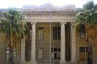 Dimmit County Courthouse in Carrizo Springs located off U.S. Highway 277 | |
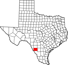 Location in the U.S. state of Texas | |
 Texas's location in the U.S. | |
| Founded | 1858 |
| Named for | Philip Dimmitt |
| Seat | Carrizo Springs |
| Largest city | Carrizo Springs |
| Area | |
| • Total | 1,335 sq mi (3,458 km2) |
| • Land | 1,329 sq mi (3,442 km2) |
| • Water | 5.6 sq mi (15 km2), 0.4% |
| Population | |
| • (2010) | 9,996 |
| • Density | 7.5/sq mi (2.9/km2) |
| Congressional district | 23rd |
| Time zone | Central: UTC−6/−5 |
| Website |
www |
Dimmit County (/ˈdɪmɪt/ DIM-it) is a county located in the U.S. state of Texas. As of the 2010 census, its population was 9,996.[1] The county seat is Carrizo Springs.[2] The county was founded in 1858 and later organized in 1880.[3] It is named for Philip Dimmitt,[4] a major figure in the Texas Revolution. The spelling of the county name and the spelling of the individual's name differ because of a spelling error in the bill creating the county name.
History
Native Americans
Paleo-Indians artifacts indicate these people lived in Dimmit County as far back as 9200 BC. Archaic period (6000 BC to AD 1000) up to the arrival of the Spanish brought increased hunter-gatherers to the area. These Indians subsisted mostly on game, wild fruits, seeds, and roots.[5] They carved tools from wood and stone, wove baskets, and sewed rabbitskin robes, made pottery and hunted with bows and arrows.[6] Their most effective weapon was the atlatl, a throwing stick that greatly increased the deadliness of their spears. Coahuiltecan Indians native to Dimmit County were later squeezed out by Apache and Comanche. Hostile tribes harassed settlers, forcing some to pull up stakes. Texas Rangers and local volunteers, as well as disease, ran the Indians out of the county by 1877.[7][8]
The Wild Horse Desert
The area between the Rio Grande and the Nueces River, which included Zavala County, became disputed territory known as the Wild Horse Desert, where neither the Republic of Texas nor the Mexican government had clear control. Ownership was in dispute until the Mexican–American War. The area became filled with lawless characters who deterred settlers in the area. An agreement signed between Mexico and the United States in the 1930s put the liability of payments to the descendants of the original land grants on Mexico.[9][10]
County established and settlements
Dimmit County was officially established in 1858 from parts of Bexar, Webb, Maverick, and Uvalde counties. The county was organized in 1880. Carrizo Springs became the county seat.[8][11]
Early settlers found Dimmit County to be an abundant grassland with mesquite, oak, and ash trees and wildlife that included buffalo, deer, turkeys, wild horses, panthers, and javelinas. Artesian springs, bubbling up from a vast reservoir of underground water, fed into running streams that harbored giant catfish, crawfish, and mussels. Explorers found the area a good place to hunt wild mustangs, and to feed and water cattle.[12]
Pioneering cattleman Levi English settled Carrizo Springs in 1865 with a group of fifteen families from Atascosa County. Within two years, they were joined by a second group of settlers from Goliad County. Early dwellings were crude adobe structures or dugouts. In 1880, Levi English donated land for a county courthouse, schools, and churches in the town.[13][14]
Lawlessness, banditry, and in particular cattle rustling from both sides of the Mexican border, pervaded until the 1880s. Marshal J. King Fisher, managed to bring about a reduction in the lawlessness. King also staunchly enforced the "dry county" law once the residents voted to outlaw the sale of alcohol.[8][15]
Dimmit County's first producing oil well was found in 1943. In 1980, Dimmit County farmers earned about $20 million for their crops, while about $60 million in oil and gas was produced.[8]
Formation of the 1914 White Man's Primary Association was designed to exclude Mexican Americans from any meaningful participation in county politics. In the 1944 Smith v. Allwright case, the United States Supreme Court found the White Primary to be unconstitutional.[16][17]
Water
D.C. Frazier drilled the first artesian well, which spouted forth gallons of water a minute, near Carrizo Springs in 1884.[18] By 1900 about twenty-five artesian wells were flowing in the Carrizo Springs area, but most of the water was wasted, and very little was used for irrigation. Colonel J. S. Taylor introduced large-scale Bermuda onion and strawberry agriculture to the area, and was the first to use irrigation on a large scale in Dimmit County. In 1899, Taylor built a thirty-foot dam across the Nueces River to irrigate 2,000 acres (8.1 km2) of farmland. He also drilled a deep artesian well. By 1910, Taylor's methods were being imitated by a number of other developers and vegetable farmers.[19] Irrigation helped make Dimmit County part of the Texas Winter Garden Region.[20] By the 1920s, however, artesian water began to dry up. The necessity of installing expensive pumps drove many farmers out of business. By 1934, the United States Department of the Interior concluded that the existing water supply would not support substantial additional development. By 1965 only about 15,000 acres (61 km2) was being irrigated. Much of the land reverted to rangeland.[8]
Oil
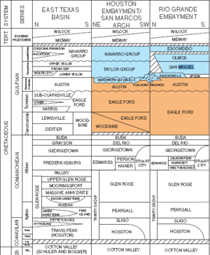
The Big Wells Oil Field, east of Big Wells was discovered in 1969. The field produces from the Cretaceous San Miguel Formation sandstone underlying the Olmos Formation sandstone. The field extends north into Zavala.[21]
The Eagle Ford oil field was reported to be under development in 2011 with 3,000 wells projected to extract oil by hydraulic fracturing from tight shale formations. The oil play has improved business activity in the county but raised fears regarding the adequacy of water supplies as fracking requires injection of large quantities of water under pressure into wells to break surrounding rock.[22]
Geography
According to the U.S. Census Bureau, the county has a total area of 1,335 square miles (3,460 km2), of which 1,329 square miles (3,440 km2) is land and 5.6 square miles (15 km2) (0.4%) is water.[23]
Major highways
Adjacent counties
- Zavala County (north)
- Frio County (northeast)
- La Salle County (east)
- Webb County (south)
- Maverick County (west)
Demographics
| Historical population | |||
|---|---|---|---|
| Census | Pop. | %± | |
| 1870 | 109 | — | |
| 1880 | 665 | 510.1% | |
| 1890 | 1,049 | 57.7% | |
| 1900 | 1,106 | 5.4% | |
| 1910 | 3,460 | 212.8% | |
| 1920 | 5,296 | 53.1% | |
| 1930 | 8,828 | 66.7% | |
| 1940 | 8,542 | −3.2% | |
| 1950 | 10,654 | 24.7% | |
| 1960 | 10,095 | −5.2% | |
| 1970 | 9,039 | −10.5% | |
| 1980 | 11,367 | 25.8% | |
| 1990 | 10,433 | −8.2% | |
| 2000 | 10,248 | −1.8% | |
| 2010 | 9,996 | −2.5% | |
| Est. 2016 | 10,794 | [24] | 8.0% |
| U.S. Decennial Census[25] 1850–2010[26] 2010–2014[1] | |||
As of the census[27] of 2000, there are 10,248 people, 3,308 households, and 2,646 families residing in the county. The population density is 8 people per square mile (3/km²). There are 4,112 housing units at an average density of 3 per square mile (1/km²). The racial makeup of the county is 76.95% White, 0.88% Black or African American, 0.70% Native American, 0.66% Asian, 0.07% Pacific Islander, 18.23% from other races, and 2.51% from two or more races. 84.97% of the population are Hispanic or Latino of any race.
There are 3,308 households out of which 42.00% have children under the age of 18 living with them, 57.40% are married couples living together, 17.20% have a female householder with no husband present, and 20.00% are non-families. 18.00% of all households are made up of individuals and 9.30% have someone living alone who is 65 years of age or older. The average household size is 3.06 and the average family size is 3.48.
In the county, the population is spread out with 33.20% under the age of 18, 8.80% from 18 to 24, 24.70% from 25 to 44, 20.70% from 45 to 64, and 12.60% who are 65 years of age or older. The median age is 32 years. For every 100 females there are 94.30 males. For every 100 females age 18 and over, there are 91.10 males.
The median income for a household in the county is $21,917, and the median income for a family is $24,579. Males have a median income of $25,000 versus $15,370 for females. The per capita income for the county is $9,765. 33.20% of the population and 29.70% of families are below the poverty line. Out of the total population, 40.30% of those under the age of 18 and 31.50% of those 65 and older are living below the poverty line. The county's per-capita income makes it one of the poorest counties in the United States.
Politics
While the state of Texas went strongly for Republican George W. Bush in the 2004 presidential election, Dimmit County, a traditional stronghold of the Democratic Party, supported U.S. Senator John F. Kerry of Massachusetts, with 2,365 votes for Kerry to 1,188 for Bush. The last Republican to win a majority in Dimmit County was Richard Nixon in 1972.[28] In 1892, Dimmit County gave all its few votes to Populist James B. Weaver, thus making it is leading county.
| Year | Republican | Democratic | Third parties |
|---|---|---|---|
| 2016 | 30.2% 974 | 67.4% 2,173 | 2.4% 78 |
| 2012 | 26.1% 762 | 73.4% 2,141 | 0.5% 14 |
| 2008 | 24.4% 874 | 75.1% 2,692 | 0.6% 21 |
| 2004 | 33.3% 1,188 | 66.3% 2,365 | 0.4% 13 |
| 2000 | 27.5% 1,032 | 71.4% 2,678 | 1.1% 43 |
| 1996 | 20.2% 604 | 75.0% 2,242 | 4.9% 145 |
| 1992 | 19.3% 844 | 72.4% 3,172 | 8.3% 364 |
| 1988 | 24.7% 900 | 74.9% 2,735 | 0.4% 16 |
| 1984 | 34.4% 1,338 | 65.4% 2,546 | 0.2% 8 |
| 1980 | 35.3% 1,173 | 63.3% 2,102 | 1.4% 48 |
| 1976 | 33.9% 890 | 65.6% 1,721 | 0.5% 13 |
| 1972 | 51.8% 1,172 | 47.7% 1,078 | 0.5% 12 |
| 1968 | 35.2% 584 | 54.0% 896 | 10.8% 180 |
| 1964 | 29.7% 501 | 70.1% 1,184 | 0.2% 3 |
| 1960 | 42.2% 648 | 57.6% 886 | 0.2% 3 |
| 1956 | 61.9% 705 | 37.5% 427 | 0.6% 7 |
| 1952 | 65.3% 954 | 34.5% 503 | 0.2% 3 |
| 1948 | 29.1% 384 | 65.5% 863 | 5.4% 71 |
| 1944 | 33.6% 328 | 56.7% 554 | 9.7% 95 |
| 1940 | 31.5% 340 | 68.2% 736 | 0.3% 3 |
| 1936 | 29.0% 296 | 69.0% 704 | 2.1% 21 |
| 1932 | 22.1% 241 | 77.3% 843 | 0.6% 6 |
| 1928 | 70.8% 626 | 29.2% 258 | |
| 1924 | 36.5% 180 | 58.6% 289 | 4.9% 24 |
| 1920 | 31.5% 108 | 67.4% 231 | 1.2% 4 |
| 1916 | 27.6% 74 | 72.0% 193 | 0.4% 1 |
| 1912 | 27.6% 131 | 61.5% 292 | 11.0% 52 |
From 1981 to 1988, the district attorney of Dimmit County was noted trial lawyer Julio A. Garcia of Laredo. At the time the office included Webb, Jim Hogg, and Zapata counties as well as Dimmit.
Education

All of Dimmit County is served by the Carrizo Springs Independent School District.
Communities
Cities
- Asherton
- Big Wells
- Carrizo Springs (county seat)
Census-designated places
See also
References
- 1 2 "State & County QuickFacts". United States Census Bureau. Archived from the original on July 9, 2011. Retrieved December 10, 2013.
- ↑ "Find a County". National Association of Counties. Archived from the original on 2011-05-31. Retrieved 2011-06-07.
- ↑ "Texas: Individual County Chronologies". Texas Atlas of Historical County Boundaries. The Newberry Library. 2008. Retrieved May 21, 2015.
- ↑ Gannett, Henry (1905). The Origin of Certain Place Names in the United States. Govt. Print. Off. p. 106.
- ↑ "Native Peoples of the South Texas Plains During Early Historic Times". Texas Beyond History. UT-Austin. Retrieved 17 December 2010.
- ↑ "Distant Connections". Texas Beyond History. UT-Austin. Retrieved 17 December 2010.
- ↑ Wishhart, David J (2004). "The Spanish and the Great Plains 1540–1821". Encyclopedia of the Great Plains. University of Nebraska Press. pp. 345, 346. ISBN 978-0-8032-4787-1.
- 1 2 3 4 5 Leffler, John. "Dimmit County, Texas". Handbook of Texas Online. Texas State Historical Association. Retrieved 17 December 2010.
- ↑ Wranker, Ralph. "The South Texas Area". Retrieved 17 December 2010.
- ↑ Bartlett, Richard C; Williamson, Leroy; Sansom, Andrew; Thornton III, Robert L (1995). "The South Texas Plains". The Wild Horse Desert. University of Texas Press. pp. 123–141. ISBN 978-0-292-70835-8.
- ↑ "Carrizo Springs, Texas". Texas Escapes. Texas Escapes – Blueprints For Travel, LLC. Retrieved 17 December 2010.
- ↑ "Nature's Harvest". Texas Beyond History. UT-Austin. Retrieved 17 December 2010.
- ↑ Leffler, John. "Levi English". Handbook of Texas Online. Texas State Historical Association. Retrieved 17 December 2010.
- ↑ Leffler, John. "Carrizo Springs". Handbook of Texas Online. Texas State Historical Association. Retrieved 17 December 2010.
- ↑ Adams, Paul. "John King Fisher". Handbook of Texas Online. Texas State Historical Association. Retrieved 17 December 2010.
- ↑ "321 U.S. 649 Smith v. Allwright". Decided: April 3, 1944. Cornell University Law School. Retrieved 17 December 2010.
- ↑ Long, Christopher. "The White Man's Union Associations". Handbook of Texas Online. Texas State Historical Association. Retrieved 17 December 2010.
- ↑ Taylor, Paul Schuster (1981). Labor on the land: collected writings 1930–1970. Arno Press. p. 83. ISBN 978-0-405-14208-6.
- ↑ Cindy, Wilke. "Onion Culture". Handbook of Texas Online. Texas State Historical Association. Retrieved 17 December 2010.
- ↑ Odintz, Mark. "Winter Garden Region". Handbook of Texas Online. Texas State Historical Association. Retrieved 16 December 2010.
- ↑ Layden, R.L. (1976). Braunstein, Jules, ed. Big Wells Field, Dimmit and Zavala Counties, Texas, in North American Oil and Gas Fields. Tulsa: The American Association of Petroleum Geologists. pp. 145–156. ISBN 0891813004.
- ↑ Krauss, Clifford (May 27, 2011). "Shale Boom in Texas Could Increase U.S. Oil Output". The New York Times. Retrieved May 28, 2011.
the hottest new oil play in the country
- ↑ "2010 Census Gazetteer Files". United States Census Bureau. August 22, 2012. Retrieved April 22, 2015.
- ↑ "Population and Housing Unit Estimates". Retrieved June 9, 2017.
- ↑ "U.S. Decennial Census". United States Census Bureau. Archived from the original on May 12, 2015. Retrieved April 22, 2015.
- ↑ "Texas Almanac: Population History of Counties from 1850–2010" (PDF). Texas Almanac. Retrieved April 22, 2015.
- ↑ "American FactFinder". United States Census Bureau. Archived from the original on 2013-09-11. Retrieved 2011-05-14.
- ↑ Sullivan, Robert David; ‘How the Red and Blue Map Evolved Over the Past Century’; America Magazine in The National Catholic Review; June 29, 2016
- ↑ Leip, David. "Dave Leip's Atlas of U.S. Presidential Elections". uselectionatlas.org. Retrieved 2018-07-21.
External links
| Wikimedia Commons has media related to Dimmit County, Texas. |
- Dimmit County in Handbook of Texas Online at the University of Texas
- Read Philip Dimmit's entry in the Biographical Encyclopedia of Texas hosted by the Portal to Texas History.
- Historic Dimmit County materials, hosted by the Portal to Texas History.
- Dimmit County History at HistoricTexas.net
- Dimmit County Profile by the Texas Association of Counties
Places adjacent to Dimmit County, Texas | ||||||||||
|---|---|---|---|---|---|---|---|---|---|---|
| ||||||||||
Municipalities and communities of Dimmit County, Texas, United States | ||
|---|---|---|
| Cities | | |
| CDPs | ||
