Comal County, Texas
| Comal County, Texas | ||
|---|---|---|
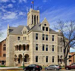 The 3.5 story Romanesque Revival style Comal County Courthouse in New Braunfels was built in 1898. | ||
| ||
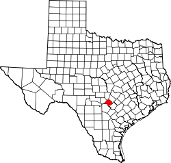 Location in the U.S. state of Texas | ||
 Texas's location in the U.S. | ||
| Founded | 1846 | |
| Seat | New Braunfels | |
| Largest city | New Braunfels | |
| Area | ||
| • Total | 575 sq mi (1,489 km2) | |
| • Land | 559 sq mi (1,448 km2) | |
| • Water | 15 sq mi (39 km2), 2.7% | |
| Population (est.) | ||
| • (2017) | 141,009[1] | |
| • Density | 252/sq mi (97/km2) | |
| Congressional districts | 21st, 35th | |
| Time zone | Central: UTC−6/−5 | |
| Website |
www | |

Comal County (/ˈkoʊmæl/ KOH-mal) is a county located on the Edwards Plateau in the U.S. state of Texas. As of the 2010 census, its population was 108,472.[2] Its county seat is New Braunfels.[3]
Comal County is part of the San Antonio-New Braunfels, TX Metropolitan Statistical Area.
Along with Hays and Kendall counties, Comal was listed in 2017 of the nation's ten fastest-growing large counties with a population of at least ten thousand. In 2017, Comal County, was second on the list, it grew grew by 5,675 newcomers, or 4.4 percent from 2015 to 2016. Kendall County was the second-fastest-growing county in the nation in 2015 to 2016, grew by 5.16 percent. Hays County, third on the national list, had nearly ten thousand new residents during the year. As a result of this growth, the counties have experienced new home construction, traffic congestion, and greater demand for public services. Bexar County, which includes San Antonio, grew by 1.75 percent during the year, but its sheer number of new residents exceeded 33,000.[4]
History
- Early native American inhabitants include Tonkawa, Waco, Karankawa and Lipan Apache.[5]
- 1700-1758 The area becomes known as “Comal”, Spanish for “flat dish”. Nuestra Senora de Guadalupe Mission at Comal Springs.[5][6]
- 1825 Coahuila y Tejas issues land grant for Comal Springs to Juan Martín de Veramendi.[6]
- 1842 Adelsverein organized in Germany to promote emigration to Texas.[7] Fisher-Miller Land Grant sets aside three million acres (12,000 km²) to settle 600 families and single men of German, Dutch, Swiss, Danish, Swedish, and Norwegian ancestry in Texas.[8]
- 1844, June 26 - Henry Francis Fisher sells interest in land grant to Adelsverein[9]
- 1845 Prince Carl of Solms-Braunfels secures title to 1,265 acres (5.12 km2) of the Veramendi grant, including the Comal Springs and River, for the Adelsverein. Thousands of German immigrants are stranded at port of disembarkation Indianaola on Matagorda Bay. With no food or shelters, living in holes dug into the ground, an estimated 50% die from disease or starvation. The living begin to walk to their destinations hundreds of miles away. 200 German colonists who walked from Indianola found the town of New Braunfels at the crossing of the San Antonio-Nacogdches Road on the Guadalupe River. John O. Meusebach arrives in Galveston.[10][11][12][13]
- 1846 March - Texas legislature forms Comal County from the Eighth Precinct of Bexar County. New Braunfels is the county seat.[5][14]
- 1850 Survey of 130 German farms in Comal reveals no slave laborers.[5]
- 1852 Neu-Braunfelser Zeitung begins publication, initially only in German, deriving its name 16th Century Germany's prototype of a newspaper titled Zeitung.[15]
- 1854 County is divided into eight public school districts.[5] The Texas State Convention of Germans meet in San Antonio and adopt a political, social and religious platform, including: 1) Equal pay for equal work; 2) Direct election of the President of the United States; 3) Abolition of capital punishment; 4) “Slavery is an evil, the abolition of which is a requirement of democratic principles..”; 5) Free schools – including universities - supported by the state, without religious influence; and 6) Total separation of church and state.[16][17]
- 1858 Final county boundaries determination with the separation of part of western Comal County to Blanco and Kendall counties. New Braunfels votes in a school tax.[5]
- 1861 Comal County votes for secession from the Union. Contributes three all-German volunteer companies-to the Confederate cause.[5]
- 1887 Faust Street Bridge built over the Guadalupe River.[18]
- 1898 Comal County limestone courthouse erected. Romanesque Revival style. Architect James Riely Gordon.[19]
- 1920s - County establishes itself as a manufacturing and shipping center for textiles, garments, flour, and construction materials.[5]
- 1960 Four students at St. Mary’s University San Antonio discover Natural Bridge Caverns, the largest known commercial caverns in the state of Texas.[20]
- 1961 Comal’s first Wurstfest draws a crowd of 2,000.[21][22]
- 1964 Canyon Lake impoundment, boosting tourism and related industries.[23]
Darmstadt Society of Forty
Count Castell[24] of the Adelsverein negotiated with the separate Darmstadt Society of Forty to colonize two hundred families on the Fisher-Miller Land Grant territory in Texas. In return, they were to receive $12,000 in money, livestock, equipment and provisions for a year. After the first year, the colonies were expected to support themselves.[25] The colonies attempted were Castell,[26] Leiningen, Bettina,[27] Schoenburg and Meerholz in Llano County; Darmstädler Farm in Comal County; and Tusculum in Kendall County.[28] Of these, only Castell survives. The colonies failed after the Adelsverein funding expired, and also due to conflict of structure and authorities. Some members moved to other Adelsverein settlements in Texas. Others moved elsewhere, or returned to Germany.
Geography
According to the U.S. Census Bureau, the county has a total area of 575 square miles (1,490 km2), of which 559 square miles (1,450 km2) is land and 15 square miles (39 km2) (2.7%) is water.[29]
The Balcones Escarpment runs northeastward through the county, generally just west of Interstate 35. West of the escarpment are the rocky hills and canyons of the Texas Hill Country; to the east are the rolling grasslands of the coastal plains.
The Guadalupe River flows generally southeastward through the county, and is impounded by Canyon Lake. The Comal River rises from the Comal Springs in New Braunfels, and quickly joins the Guadalupe River.
Major highways
Adjacent counties
- Blanco County (north)
- Hays County (northeast)
- Guadalupe County (southeast)
- Bexar County (southwest)
- Kendall County (northwest)
Demographics
| Historical population | |||
|---|---|---|---|
| Census | Pop. | %± | |
| 1850 | 1,723 | — | |
| 1860 | 4,030 | 133.9% | |
| 1870 | 5,283 | 31.1% | |
| 1880 | 5,546 | 5.0% | |
| 1890 | 6,398 | 15.4% | |
| 1900 | 7,008 | 9.5% | |
| 1910 | 8,434 | 20.3% | |
| 1920 | 8,824 | 4.6% | |
| 1930 | 11,984 | 35.8% | |
| 1940 | 12,321 | 2.8% | |
| 1950 | 16,357 | 32.8% | |
| 1960 | 19,844 | 21.3% | |
| 1970 | 24,165 | 21.8% | |
| 1980 | 36,446 | 50.8% | |
| 1990 | 51,832 | 42.2% | |
| 2000 | 78,021 | 50.5% | |
| 2010 | 108,472 | 39.0% | |
| Est. 2017 | 141,009 | [30] | 30.0% |
| U.S. Decennial Census[31] 1850–2010[32] 2010–2014[2] | |||
As of the census[33] of 2010, there were 108,472 people, 29,066 households, and 21,886 families residing in the county. The population density was 139 people per square mile (54/km²). There were 32,718 housing units at an average density of 58 per square mile (22/km²). The racial makeup of the county was 89.08% White, 0.95% Black or African American, 0.53% Native American, 0.46% Asian, 0.03% Pacific Islander, 6.98% from other races, and 1.96% from two or more races. 22.57% of the population were Hispanic or Latino of any race.
There were 29,066 households out of which 33.30% had children under the age of 18 living with them, 62.80% were married couples living together, 9.00% had a female householder with no husband present, and 24.70% were non-families. 20.60% of all households were made up of individuals and 9.00% had someone living alone who was 65 years of age or older. The average household size was 2.64 and the average family size was 3.05.
A Williams Institute analysis of 2010 census data found there were about 4.4 same-sex couples per 1,000 households in the county.[34]
In the county, the population was spread out with 25.50% under the age of 18, 7.00% from 18 to 24, 27.50% from 25 to 44, 25.20% from 45 to 64, and 14.80% who were 65 years of age or older. The median age was 39 years. For every 100 females, there were 96.00 males. For every 100 females age 18 and over, there were 93.20 males.
The median income for a household in the county was $46,147, and the median income for a family was $52,455. Males had a median income of $36,048 versus $25,940 for females. The per capita income for the county was $21,914. About 6.40% of families and 8.60% of the population were below the poverty line, including 11.50% of those under age 18 and 7.30% of those age 65 or over.
Politics
Comal is a strongly Republican county: the last Democrat to carry it being Lyndon B. Johnson in 1964, and no others have done so since Franklin Roosevelt’s 1936 landslide when he won every Texas county bar traditionally Unionist Gillespie and Kendall and took 87.31 percent of the Lone Star State’s vote. In earlier periods, the county’s German heritage meant it often deviated from “Solid South” Democratic voting: in 1924 Robert La Follette won 73.96 percent of Comal County’s vote (versus 6.52 percent for all of Texas), which made it his strongest county nationwide,[35] and in 1920 American candidate James “Pa” Ferguson carried the county with 841 votes to 765 for Warren G. Harding.[36]
| Year | Republican | Democratic | Third parties |
|---|---|---|---|
| 2016 | 72.6% 45,136 | 22.9% 14,238 | 4.5% 2,804 |
| 2012 | 76.3% 39,318 | 22.2% 11,450 | 1.5% 761 |
| 2008 | 73.0% 35,233 | 25.7% 12,384 | 1.3% 644 |
| 2004 | 76.9% 31,574 | 22.3% 9,153 | 0.8% 316 |
| 2000 | 75.1% 24,599 | 21.8% 7,131 | 3.1% 1,018 |
| 1996 | 64.3% 16,763 | 27.4% 7,132 | 8.3% 2,162 |
| 1992 | 50.7% 12,651 | 25.3% 6,312 | 24.0% 5,978 |
| 1988 | 70.0% 13,994 | 28.6% 5,716 | 1.4% 270 |
| 1984 | 76.1% 13,452 | 23.6% 4,179 | 0.3% 52 |
| 1980 | 71.2% 9,758 | 25.9% 3,554 | 2.9% 402 |
| 1976 | 60.4% 6,377 | 38.5% 4,068 | 1.0% 109 |
| 1972 | 78.4% 6,761 | 21.1% 1,823 | 0.5% 44 |
| 1968 | 54.3% 3,646 | 34.8% 2,338 | 10.8% 726 |
| 1964 | 37.8% 2,223 | 62.0% 3,644 | 0.1% 8 |
| 1960 | 62.4% 3,082 | 37.3% 1,845 | 0.3% 14 |
| 1956 | 74.5% 3,397 | 25.0% 1,140 | 0.4% 20 |
| 1952 | 72.7% 3,350 | 27.2% 1,252 | 0.1% 4 |
| 1948 | 57.0% 1,752 | 39.4% 1,212 | 3.6% 110 |
| 1944 | 67.6% 2,021 | 26.3% 787 | 6.1% 181 |
| 1940 | 68.4% 1,852 | 31.5% 851 | 0.1% 3 |
| 1936 | 25.5% 554 | 74.2% 1,611 | 0.3% 6 |
| 1932 | 7.3% 176 | 92.1% 2,211 | 0.6% 15 |
| 1928 | 21.1% 508 | 78.8% 1,893 | 0.1% 2 |
| 1924 | 12.7% 312 | 13.4% 330 | 74.0% 1,823 |
| 1920 | 42.0% 765 | 10.0% 181 | 48.0% 874 |
| 1916 | 61.3% 743 | 35.6% 432 | 3.1% 38 |
| 1912 | 16.8% 157 | 64.5% 602 | 18.7% 174 |
The county is part of the 21st District in the United States House of Representatives, represented by Republican Lamar S. Smith, the 25th district of the Texas State Senate, represented by Republican Donna Campbell, and the 73rd District of the Texas House of Representatives and is represented by Republican Kyle Biedermann. Biedermann’s predecessors in the House seat are Republicans. They include Nathan Macias, a businessman from Bulverde, Carter Casteel, a former Comal County county judge and a lawyer in New Braunfels, and Doug Miller, a former mayor of New Braunfels.
Communities
Cities (multiple counties)
- Fair Oaks Ranch (partly in Bexar and Kendall counties)
- New Braunfels (county seat) (mostly in Comal County but also in Guadalupe County as well)
- San Antonio (mostly in Bexar County and a small part in Medina County)
- Schertz (partly in Guadalupe and Bexar counties)
- Selma (mostly in Bexar and Guadalupe counties)
Cities
Towns
Census-designated place
Other unincorporated communities
Ghost towns
In popular culture
- The Jason Boland song "Comal County Blue" is about the county.
- The Bleu Edmondson song "No Room For Mercy" takes place in the county.
See also
References
- ↑ "U.S. Census Bureau QuickFacts: Comal County, Texas".
- 1 2 "State & County QuickFacts". United States Census Bureau. Archived from the original on July 8, 2011. Retrieved December 9, 2013.
- ↑ "Find a County". National Association of Counties. Archived from the original on 2011-05-31. Retrieved 2011-06-07.
- ↑ Zeke MacCormack, "Folks flocking to area counties: Kendall, Comal, and Hays are on the top 10 list", San Antonio Express-News, March 24, 2017, pp. 1, A11.
- 1 2 3 4 5 6 7 8 Greene, Daniel P (2010-06-12). "Comal County". Handbook of Texas Online. Texas State Historical Association. Archived from the original on 21 December 2010. Retrieved 29 November 2010.
- 1 2 Ladd, Kevin (2009). Gone to Texas: Genealogical Abstracts from The Telegraph and Texas Register, 1835-1841. Heritage Books Inc. p. 68. ISBN 978-0-7884-0005-6.
- ↑ Brister, Louis E. (2010-06-09). "Adelsverein". Handbook of Texas Online. Texas State Historical Association. Archived from the original on 25 November 2010. Retrieved 29 November 2010.
- ↑ Ramos, Mary G. "The German Settlements in Central Texas". Texas Almanac. Texas State Historical Association. Archived from the original on 7 February 2011. Retrieved 29 November 2010.
- ↑ Kohout, Martin Donnell (2010-06-15). "Gillespie County, Texas". Handbook of Texas Online. Texas State Historical Association. Archived from the original on 21 December 2010. Retrieved 29 November 2010.
- ↑ "Indianola, Texas". Blueprints For Travel, LLC. Archived from the original on 20 May 2011. Retrieved 29 November 2010.
- ↑ Block, W T. "The Story of our Texas' German Pilgrims". Blueprints For Travel, LLC. Archived from the original on 20 May 2011. Retrieved 29 November 2010.
- ↑ "Near River Crossing Used by New Braunfels' First Settlers - New Braunfels, Comal County, Texas". William Nienke, Sam Morrow. Archived from the original on 18 July 2011. Retrieved 29 November 2010.
- ↑ Smith, Cornelia Marshall; Tetzlaff, Otto W (2010-06-15). "Meusebach, John O". Handbook of Texas Online. Texas State Historical Association. Archived from the original on 26 November 2010. Retrieved 29 November 2010.
- ↑ "New Braunfels, Texas". Texas Escapes. Texas Escapes - Blueprints For Travel, LLC. Archived from the original on 14 May 2011. Retrieved 29 November 2010.
- ↑ Bernhard, Jim (2007). Porcupine, Picayune, & Post: How Newspapers Get Their Names. University of Missouri Press. p. 38. ISBN 978-0-8262-1748-6.
- ↑ Biesele, R. L. (April 1930). "The Texas State Convention of Germans in 1854". Southwestern Historical Quarterly. 33 (4): 247–261.
- ↑ "Nimitz, Charles and Sophia". Der Stadt Friedhof. Gillespie County Historical Association. Archived from the original on 26 July 2011. Retrieved 13 November 2010.
- ↑ "Faust Street Bridge". Texas Escapes. Texas Escapes - Blueprints For Travel, LLC. Archived from the original on 14 May 2011. Retrieved 29 November 2010.
- ↑ "Comal County Courthouse". Texas Escapes. Texas Escapes - Blueprints For Travel, LLC. Archived from the original on 20 May 2011. Retrieved 29 November 2010.
- ↑ "Natural Bridge Caverns - New Braunfels, Comal County, Texas". Texas State Historical Markers. William Nienke, Sam Morrow. Archived from the original on 13 March 2011. Retrieved 29 November 2010.
- ↑ "Wurstfest History". Greater New Braunfels Chamber of Commerce. Archived from the original on 12 July 2001. Retrieved 29 November 2010.
- ↑ Permenter, Paris; Bigley, John (2006). Day Trips from San Antonio. GPP Travel. p. 27. ISBN 978-0-7627-3868-7.
- ↑ "Canyon Lake". Texas Parks and Wildlife Department. Archived from the original on 4 January 2011. Retrieved 29 November 2010.
- ↑ Brister, Louis E (2010-06-12). "Count Carl of Castell-Castell". Handbook of Texas Online. Texas State Historical Association. Archived from the original on 15 July 2011. Retrieved 16 January 2011.
- ↑ King (1967) p.122
- ↑ Heckert-Greene, James B (2010-06-12). "Castell, Texas". Handbook of Texas Online. Texas State Historical Association. Archived from the original on 15 July 2011. Retrieved 20 January 2011.
- ↑ Lich, Glen E (2010-06-12). "Bettina, Texas". Handbook of Texas Online. Texas State Historical Association. Archived from the original on 15 July 2011. Retrieved 20 January 2011.
- ↑ Lich, Glen E (2010-06-12). "The Forty". Handbook of Texas Online. Texas State Historical Association. Archived from the original on 9 July 2011. Retrieved 20 January 2011.
- ↑ "2010 Census Gazetteer Files". United States Census Bureau. August 22, 2012. Archived from the original on April 19, 2015. Retrieved April 21, 2015.
- ↑ "Population and Housing Unit Estimates". Archived from the original on May 4, 2018. Retrieved June 9, 2017.
- ↑ "U.S. Decennial Census". United States Census Bureau. Archived from the original on April 22, 2013. Retrieved April 21, 2015.
- ↑ "Texas Almanac: Population History of Counties from 1850–2010" (PDF). Texas Almanac. Archived (PDF) from the original on February 26, 2015. Retrieved April 21, 2015.
- ↑ "American FactFinder". United States Census Bureau. Archived from the original on 2013-09-11. Retrieved 2011-05-14.
- ↑ Leonhardt, David; Quealy, Kevin (June 26, 2015), "Where Same-Sex Couples Live", The New York Times, archived from the original on June 29, 2015, retrieved July 6, 2015
- ↑ Dave Leip’s U.S. Election Atlas; 1924 Presidential Election Statistics Archived 2018-01-25 at the Wayback Machine.
- ↑ Géoelections; Popular Vote for Eugene V. Debs Archived 2006-09-02 at the Wayback Machine. (.xlsx file for €15)
- ↑ Leip, David. "Dave Leip's Atlas of U.S. Presidential Elections". uselectionatlas.org. Archived from the original on 2018-03-23.
External links
- Library of Congress Historic American Buildings Survey (Comal Co)
- Comal County government’s website
- Comal County from the Handbook of Texas Online
- Canyon Lake Area Chamber of Commerce
- Historic materials from Comal County, hosted by the Portal to Texas History
Places adjacent to Comal County, Texas | ||||||||||
|---|---|---|---|---|---|---|---|---|---|---|
| ||||||||||
Municipalities and communities of Comal County, Texas, United States | ||
|---|---|---|
| Cities | | |
| CDP | ||
| Unincorporated communities | ||
| Ghost town | ||
| Footnotes | ‡This populated place also has portions in an adjacent county or counties | |
