Brazos County, Texas
| Brazos County, Texas | ||
|---|---|---|
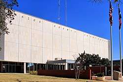 The Brazos County Courthouse in Bryan | ||
| ||
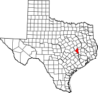 Location in the U.S. state of Texas | ||
 Texas's location in the U.S. | ||
| Founded | 1843 | |
| Named for | Brazos River | |
| Seat | Bryan | |
| Largest city | College Station | |
| Area | ||
| • Total | 591 sq mi (1,531 km2) | |
| • Land | 585 sq mi (1,515 km2) | |
| • Water | 5.8 sq mi (15 km2), 1.0% | |
| Population (est.) | ||
| • (2014) | 209,152 | |
| • Density | 333/sq mi (129/km2) | |
| Congressional district | 17th | |
| Time zone | Central: UTC−6/−5 | |
| Website |
www | |

Brazos County (/ˈbræzəs/ (![]()
Brazos County is part of the Bryan-College Station, Texas Metropolitan Statistical Area, which consists of Bryan, College Station, and smaller cities and towns in Brazos, Burleson, and Robertson counties.
History
In 1837 most of the area of present-day Brazos County was included in Washington County. The Brazos River, which bisected the latter, proved a serious obstacle to county government, and a new county, Navasota, was formed in January 1841. The first court, with Judge R. E. B. Baylor presiding, was held later that year in the home of Joseph Ferguson, fourteen miles west of the site of present Bryan. The county seat, named Boonville for Mordecai Boon, was located on John Austin's league and was surveyed by Hiram Hanover in 1841. In January of the following year Navasota County was renamed Brazos County.[5]
Originally one of the state's poorer counties, the county donated 2,416 acres of land in the 1870s to create Texas A&M University, which has enabled the county to be among the state's most financially successful.
Geography
According to the U.S. Census Bureau, the county has a total area of 591 square miles (1,530 km2), of which 585 square miles (1,520 km2) is land and 5.8 square miles (15 km2) (1.0%) is water.[6]
Adjacent counties
- Burleson County (southwest)
- Grimes County (east)
- Madison County (northeast)
- Robertson County (northwest)
- Washington County (south)
Demographics
| Historical population | |||
|---|---|---|---|
| Census | Pop. | %± | |
| 1850 | 614 | — | |
| 1860 | 3,096 | 404.2% | |
| 1870 | 9,205 | 197.3% | |
| 1880 | 13,576 | 47.5% | |
| 1890 | 16,650 | 22.6% | |
| 1900 | 18,859 | 13.3% | |
| 1910 | 18,919 | 0.3% | |
| 1920 | 21,975 | 16.2% | |
| 1930 | 21,835 | −0.6% | |
| 1940 | 26,997 | 23.6% | |
| 1950 | 38,390 | 42.2% | |
| 1960 | 44,895 | 16.9% | |
| 1970 | 57,978 | 29.1% | |
| 1980 | 94,492 | 63.0% | |
| 1990 | 121,862 | 29.0% | |
| 2000 | 152,415 | 25.1% | |
| 2010 | 194,851 | 27.8% | |
| Est. 2016 | 220,417 | [7] | 13.1% |
| U.S. Decennial Census[8] 1850–2010[9] 2010–2014[1] | |||
As of the census[10] of 2000, there were 152,415 people, 55,202 households, and 30,416 families residing in the county. The population density was 260 people per square mile (100/km²). There were 59,023 housing units at an average density of 101 per square mile (39/km²). The racial makeup of the county was 74.45% White, 10.72% Black or African American, 0.36% Native American, 4.01% Asian, 0.07% Pacific Islander, 8.42% from other races, and 1.97% from two or more races. 17.88% of the population were Hispanic or Latino of any race. 15.3% were of German, 8.4% English, 7.3% Irish and 7.2% American ancestry according to Census 2000.
There were 55,202 households out of which 27.90% had children under the age of 18 living with them, 41.30% were married couples living together, 10.00% had a female householder with no husband present, and 44.90% were non-families. 25.50% of all households were made up of individuals and 5.00% had someone living alone who was 65 years of age or older. The average household size was 2.52 and the average family size was 3.16.
In the county, the population was spread out with 21.50% under the age of 18, 32.00% from 18 to 24, 26.00% from 25 to 44, 13.80% from 45 to 64, and 6.70% who were 65 years of age or older. The median age was 24 years. For every 100 females, there were 102.10 males. For every 100 females age 18 and over, there were 100.30 males.
The median income for a household in the county was $29,104, and the median income for a family was $46,530. Males had a median income of $32,864 versus $24,179 for females. The per capita income for the county was $16,212. About 14.00% of families and 26.90% of the population were below the poverty line, including 21.60% of those under age 18 and 10.30% of those age 65 or over.
Transportation
Public Transportation
The Brazos Transit District operates a fixed route bus service and paratransit throughout Bryan and College Station.[11][12]
Major highways
Airport
Easterwood Airport, owned by Texas A&M, is the local commercial airport, with flights to Dallas/Fort Worth International Airport and George Bush Intercontinental Airport in Houston.
Politics
Brazos County is a Republican stronghold, with no Democrat carrying the county since Texas native Lyndon Johnson in his 1964 landslide.
| Year | Republican | Democratic | Third parties |
|---|---|---|---|
| 2016 | 57.6% 38,738 | 34.4% 23,121 | 8.0% 5,352 |
| 2012 | 66.5% 37,209 | 31.2% 17,477 | 2.3% 1,276 |
| 2008 | 63.9% 37,465 | 34.9% 20,502 | 1.2% 706 |
| 2004 | 69.2% 37,594 | 29.7% 16,128 | 1.1% 587 |
| 2000 | 70.0% 32,864 | 26.3% 12,359 | 3.7% 1,718 |
| 1996 | 57.1% 22,082 | 36.2% 13,968 | 6.7% 2,594 |
| 1992 | 48.5% 23,943 | 30.0% 14,819 | 21.4% 10,578 |
| 1988 | 65.7% 29,369 | 33.3% 14,885 | 1.0% 436 |
| 1984 | 73.6% 34,733 | 26.2% 12,348 | 0.3% 140 |
| 1980 | 60.3% 17,798 | 33.4% 9,856 | 6.4% 1,885 |
| 1976 | 58.8% 15,685 | 39.8% 10,628 | 1.5% 387 |
| 1972 | 71.0% 14,243 | 28.4% 5,692 | 0.6% 116 |
| 1968 | 43.9% 6,839 | 40.4% 6,299 | 15.7% 2,441 |
| 1964 | 33.3% 4,003 | 66.5% 7,998 | 0.2% 18 |
| 1960 | 43.5% 4,553 | 56.4% 5,907 | 0.2% 17 |
| 1956 | 58.6% 4,942 | 41.1% 3,463 | 0.4% 31 |
| 1952 | 52.6% 4,681 | 47.4% 4,213 | 0.0% 2 |
| 1948 | 27.7% 1,533 | 62.6% 3,459 | 9.7% 538 |
| 1944 | 10.6% 464 | 76.8% 3,358 | 12.6% 553 |
| 1940 | 12.9% 617 | 86.9% 4,151 | 0.2% 9 |
| 1936 | 1.7% 45 | 98.2% 2,610 | 0.2% 4 |
| 1932 | 7.0% 195 | 92.4% 2,588 | 0.6% 18 |
| 1928 | 33.2% 738 | 66.6% 1,480 | 0.1% 3 |
| 1924 | 10.4% 255 | 87.1% 2,128 | 2.5% 61 |
| 1920 | 12.8% 277 | 59.0% 1,281 | 28.3% 614 |
| 1916 | 20.9% 273 | 78.5% 1,027 | 0.6% 8 |
| 1912 | 14.9% 142 | 80.0% 762 | 5.1% 49 |
Communities
Cities
- Bryan (county seat)
- College Station
- Wixon Valley
Towns
Census-designated place
Unincorporated community
- Benchley (partly in Robertson County)
- Wellborn
Ghost Town
See also
References
- 1 2 "State & County QuickFacts". United States Census Bureau. Retrieved December 8, 2013.
- ↑ "Find a County". National Association of Counties. Archived from the original on 2011-06-15. Retrieved 2011-06-07.
- ↑ "Texas: Individual County Chronologies". Texas Atlas of Historical County Boundaries. The Newberry Library. 2008. Retrieved June 20, 2015.
- ↑ "Brazos County". Texas Almanac. Texas State Historical Association. Retrieved June 20, 2015.
- ↑ Brazos County in Handbook of Texas Online
- ↑ "2010 Census Gazetteer Files". United States Census Bureau. August 22, 2012. Retrieved April 19, 2015.
- ↑ "Population and Housing Unit Estimates". Retrieved June 9, 2017.
- ↑ "U.S. Decennial Census". United States Census Bureau. Archived from the original on May 12, 2015. Retrieved April 19, 2015.
- ↑ "Texas Almanac: Population History of Counties from 1850–2010" (PDF). Texas Almanac. Retrieved April 19, 2015.
- ↑ "American FactFinder". United States Census Bureau. Archived from the original on 2013-09-11. Retrieved 2011-05-14.
- ↑ "The District Fixed Routes". Brazos Transit District. Retrieved 16 March 2014.
- ↑ "The District Paratransit". Brazos Transit District. Retrieved 16 March 2014.
- ↑ Leip, David. "Dave Leip's Atlas of U.S. Presidential Elections". uselectionatlas.org. Retrieved 2018-07-19.
External links
- Brazos County government
- Brazos County AgriLife Extension office
- Brazos County Attorney's Office
- Brazos County, Texas from the Handbook of Texas Online
- Brazos County from the Texas Almanac
- Brazos County from the TXGenWeb Project
- Historic Brazos County materials, hosted by the Portal to Texas History
Places adjacent to Brazos County, Texas | ||||||||||
|---|---|---|---|---|---|---|---|---|---|---|
| ||||||||||
Municipalities and communities of Brazos County, Texas, United States | ||
|---|---|---|
| Cities | | |
| Towns | ||
| CDP | ||
| Unincorporated communities | ||
| Ghost towns | ||
