Marion County, Texas
| Marion County, Texas | |
|---|---|
.jpg) The Marion County Courthouse in Jefferson | |
 Location in the U.S. state of Texas | |
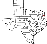
 Texas's location in the U.S. | |
| Founded | 1860 |
| Named for | Francis Marion |
| Seat | Jefferson |
| Largest city | Jefferson |
| Area | |
| • Total | 420 sq mi (1,088 km2) |
| • Land | 381 sq mi (987 km2) |
| • Water | 39 sq mi (101 km2), 9.4% |
| Population | |
| • (2010) | 10,546 |
| • Density | 28/sq mi (11/km2) |
| Congressional district | 4th |
| Time zone | Central: UTC−6/−5 |
| Website |
www |
Marion County is a county located in the U.S. state of Texas. As of the 2010 census, its population was 10,546.[1] Its county seat is Jefferson.[2] Marion County is in East Texas and is named for Francis Marion, the Revolutionary War general from South Carolina who was nicknamed the "Swamp Fox".
History
Native Americans
The farming Caddoan Mississippian culture dates as far back as 200 BCE in the area. The Hernando de Soto expedition of 1541 resulted in violent encounters. Spanish and French missionaries brought a smallpox, measles malaria and influenza epidemics against which the Caddo had no immunity. Eventually, the Caddo were forced to reservations.[3][4] Shashidahnee (Timber Hill) is the last known permanent Marion County settlement of the Caddo people. The 19th Century saw Shawnee, Delaware, and Kickapoo in the area.[5]
County established
The legislature formed Marion County from Cass County in 1860 and named for Revolutionary War Swamp Fox Francis Marion.[6] Jefferson, named after Thomas Jefferson became the county seat.[7]
The majority of the settlers migrated from other southern states and brought their slaves with them. The county was developed as cotton plantations, and enslaved African Americans made up 51 percent of the population in 1860. In 1861, the white male voters in the county voted unanimously for secession from the Union. The county benefitted financially from Confederate government contracts.[8]
One of the county’s most famous disasters occurred in February 1869, when the steamboat Mittie Stephens caught fire from a torch basket that ignited a hay stack on board. Sixty-one people died, either from the fire or from being caught in the boat’s paddlewheel as they jumped overboard.[9][10]
On October 4, 1869, George Washington Smith, a delegate to the Constitutional Convention, was murdered by a band of vigilantes while incarcerated in Jefferson. Smith's slaying led to occupation of Jefferson by military troops who offered protection for the black majority.[11]
Republican presidential races benefited from the black majority in the county. In 1898, the White Primary went into effect and disfranchised the black vote.[12]
The Marion County brick courthouse was erected in 1914, architect Elmer George Withers.[13] Outside the building the Dick Taylor Camp of Confederate veterans erected a monument to honor the county’s dead in the American Civil War.[14]
Caddo Lake State Park was first proposed in 1924. 1933-1937 the Civilian Conservation Corps made improvements to the park. The Army barracks and mess hall were converted to log cabins and a recreation hall for park goers.[15]
Geography
According to the U.S. Census Bureau, the county has a total area of 420 square miles (1,100 km2), of which 381 square miles (990 km2) is land and 39 square miles (100 km2) (9.4%) is water.[16]
Major highways

.svg.png)


The TTC-69 component (recommended preferred) of the once-planned Trans-Texas Corridor went through Marion County.[17]
Adjacent counties and parish
- Cass County (north)
- Caddo Parish, Louisiana (east)
- Harrison County (south)
- Upshur County (west)
- Morris County (northwest)
Demographics
| Historical population | |||
|---|---|---|---|
| Census | Pop. | %± | |
| 1860 | 3,977 | — | |
| 1870 | 8,562 | 115.3% | |
| 1880 | 10,983 | 28.3% | |
| 1890 | 10,862 | −1.1% | |
| 1900 | 10,754 | −1.0% | |
| 1910 | 10,472 | −2.6% | |
| 1920 | 10,886 | 4.0% | |
| 1930 | 10,371 | −4.7% | |
| 1940 | 11,457 | 10.5% | |
| 1950 | 10,172 | −11.2% | |
| 1960 | 8,049 | −20.9% | |
| 1970 | 8,517 | 5.8% | |
| 1980 | 10,360 | 21.6% | |
| 1990 | 9,984 | −3.6% | |
| 2000 | 10,941 | 9.6% | |
| 2010 | 10,546 | −3.6% | |
| Est. 2016 | 10,147 | [18] | −3.8% |
| U.S. Decennial Census[19] 1850–2010[20] 2010–2014[1] | |||
As of the census[21] of 2000, there were 10,941 people, 4,610 households, and 3,120 families residing in the county. The population density was 29 people per square mile (11/km²). There were 6,384 housing units at an average density of 17 per square mile (6/km²). The racial makeup of the county was 72.74% White, 23.91% Black or African American, 0.80% Native American, 0.22% Asian, 0.01% Pacific Islander, 0.79% from other races, and 1.54% from two or more races. 2.40% of the population were Hispanic or Latino of any race.
The largest ancestry groups in Marion County are:
- English - 49%
- Black or African American - 24%
- Irish - 6%
- German - 5%
- Scotch-Irish - 4%
- Scottish - 4%
- Dutch - 3%
- Italian - 2%
- French or French Canadian (except Basque) - 2%
- Mexican - 2%
- Polish - 1%
There were 4,610 households out of which 24.50% had children under the age of 18 living with them, 51.70% were married couples living together, 11.90% had a female householder with no husband present, and 32.30% were non-families. 28.80% of all households were made up of individuals and 13.80% had someone living alone who was 65 years of age or older. The average household size was 2.35 and the average family size was 2.88.
In the county, the population was spread out with 22.30% under the age of 18, 6.40% from 18 to 24, 23.60% from 25 to 44, 28.40% from 45 to 64, and 19.20% who were 65 years of age or older. The median age was 43 years. For every 100 females there were 95.40 males. For every 100 females age 18 and over, there were 91.40 males.
The median income for a household in the county was $25,347, and the median income for a family was $32,039. Males had a median income of $30,584 versus $17,885 for females. The per capita income for the county was $14,535. About 17.80% of families and 22.40% of the population were below the poverty line, including 29.90% of those under age 18 and 14.40% of those age 65 or over.
Communities
Cities
Census-designated place
Other unincorporated communities
- Berea
- Crestwood
- Gray
- Jackson
- Lodi
- Potters Point
- Smithland
- Warlock
Ghost town
Politics
| Year | Republican | Democratic | Third parties |
|---|---|---|---|
| 2016 | 70.4% 2,983 | 27.5% 1,165 | 2.1% 90 |
| 2012 | 63.8% 2,733 | 34.9% 1,495 | 1.3% 54 |
| 2008 | 60.4% 2,567 | 38.7% 1,644 | 1.0% 41 |
| 2004 | 56.1% 2,441 | 43.3% 1,884 | 0.5% 23 |
| 2000 | 51.9% 2,039 | 47.1% 1,852 | 1.0% 39 |
| 1996 | 34.5% 1,260 | 55.5% 2,028 | 10.1% 369 |
| 1992 | 29.0% 1,245 | 50.3% 2,156 | 20.7% 887 |
| 1988 | 45.0% 1,857 | 54.6% 2,255 | 0.4% 17 |
| 1984 | 52.3% 2,336 | 47.3% 2,111 | 0.4% 16 |
| 1980 | 44.7% 1,666 | 54.0% 2,015 | 1.3% 49 |
| 1976 | 40.8% 1,291 | 58.7% 1,860 | 0.5% 16 |
| 1972 | 60.2% 1,680 | 39.6% 1,106 | 0.1% 4 |
| 1968 | 22.3% 637 | 44.2% 1,260 | 33.5% 957 |
| 1964 | 40.3% 927 | 59.6% 1,372 | 0.2% 4 |
| 1960 | 43.9% 742 | 53.5% 904 | 2.7% 45 |
| 1956 | 60.9% 1,126 | 38.4% 709 | 0.7% 13 |
| 1952 | 47.4% 877 | 52.5% 970 | 0.1% 2 |
| 1948 | 18.5% 200 | 65.0% 703 | 16.6% 179 |
| 1944 | 15.9% 219 | 76.5% 1,057 | 7.6% 105 |
| 1940 | 11.8% 167 | 88.2% 1,253 | |
| 1936 | 12.3% 129 | 87.7% 919 | |
| 1932 | 8.8% 84 | 90.5% 861 | 0.6% 6 |
| 1928 | 40.9% 443 | 59.1% 640 | |
| 1924 | 33.0% 347 | 59.0% 620 | 8.0% 84 |
| 1920 | 34.7% 392 | 38.1% 430 | 27.3% 308 |
| 1916 | 27.0% 166 | 72.5% 445 | 0.5% 3 |
| 1912 | 18.5% 85 | 73.7% 339 | 7.8% 36 |
See also
References
- 1 2 "State & County QuickFacts". United States Census Bureau. Archived from the original on July 14, 2011. Retrieved December 21, 2013.
- ↑ "Find a County". National Association of Counties. Retrieved 2011-06-07.
- ↑ "Caddo Timeline". Texas Beyond History. UT-Austin. Retrieved 17 December 2010.
- ↑ "Caddo History". Oklahoma Historical Society. Archived from the original on 19 July 2010. Retrieved 17 December 2010.
- ↑ Teague, Wells (2000). "Where We Came From". Calling Texas Home: A Lively Look at What It Means to Be a Texan. Wildcat Canyon Press. p. 15. ISBN 978-1-885171-38-2.
- ↑ The History of Marion County. Union Historical Company. 1881. pp. 248–249.
- ↑ "Jefferson, Texas". Texas Escapes. Texas Escapes - Blueprints For Travel, LLC. Retrieved 17 December 2010.
- ↑ Atkins, Mark Howard. "Marion County, Texas". Handbook of Texas Online. Texas State Historical Association. Retrieved 17 December 2010.
- ↑ Hodge, Larry D (2000). Official Guide to Texas Wildlife Management Areas. Texas Parks and Wildlife Press. p. 133. ISBN 978-1-885696-35-9.
- ↑ McDonald, PhD, Archie P. "The Mittie Stephens Disaster". Texas Escapes. Texas Escapes - Blueprints For Travel, LLC. Retrieved 17 December 2010.
- ↑ Lale, Max S. "Stockade Case". Handbook of Texas Online. Texas State Historical Association. Retrieved 17 December 2010.
- ↑ Greenberg, Sanford N. "White Primary". Handbook of Texas Online. Texas State Historical Association. Retrieved 17 December 2010.
- ↑ "Marion County Courthouse". Texas Escapes. Texas Escapes - Blueprints For Travel, LLC. Retrieved 17 December 2010.
- ↑ "Confederate Monument". Texas Confederate Veterans. Retrieved 17 December 2010.
- ↑ "Caddo Lake State Park". Texas Parks and Wildlife Department. Retrieved 17 December 2010.
- ↑ "2010 Census Gazetteer Files". United States Census Bureau. August 22, 2012. Retrieved May 4, 2015.
- ↑ TxDoT, TTC Section F, Detailed Maps 1 & 2, 2007-12-28 Archived 2009-02-07 at the Wayback Machine.
- ↑ "Population and Housing Unit Estimates". Retrieved June 9, 2017.
- ↑ "U.S. Decennial Census". United States Census Bureau. Retrieved May 4, 2015.
- ↑ "Texas Almanac: Population History of Counties from 1850–2010" (PDF). Texas Almanac. Retrieved May 4, 2015.
- ↑ "American FactFinder". United States Census Bureau. Retrieved 2011-05-14.
- ↑ Leip, David. "Dave Leip's Atlas of U.S. Presidential Elections". uselectionatlas.org. Retrieved 2018-07-26.
External links
- Marion County government website
- Marion County from the Handbook of Texas Online
- Inventory of the county archives of Texas : Marion County, no. 158, hosted by the Portal to Texas History
Places adjacent to Marion County, Texas | ||||||||||
|---|---|---|---|---|---|---|---|---|---|---|
| ||||||||||
Municipalities and communities of Marion County, Texas, United States | ||
|---|---|---|
| City | | |
| CDP | ||
| Unincorporated community | ||
| Ghost town | ||
