Chambers County, Texas
| Chambers County, Texas | |
|---|---|
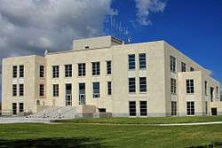 The Chambers County Courthouse in Anahuac | |
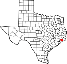 Location in the U.S. state of Texas | |
 Texas's location in the U.S. | |
| Founded | 1858 |
| Seat | Anahuac |
| Largest city | Mont Belvieu |
| Area | |
| • Total | 871 sq mi (2,256 km2) |
| • Land | 597 sq mi (1,546 km2) |
| • Water | 274 sq mi (710 km2), 31% |
| Population (est.) | |
| • (2017) | 41,441[1] |
| • Density | 69/sq mi (27/km2) |
| Congressional districts | 14th, 36th |
| Time zone | Central: UTC−6/−5 |
| Website |
www |
Chambers County is a county in the U.S. state of Texas. As of the 2010 census, the population was 35,096.[2] The county seat is Anahuac.[3]
Chambers County is included in the Houston-The Woodlands-Sugar Land, TX Metropolitan Statistical Area.
History
Mission Nuestra Señora de la Luz, a Spanish mission in Texas, was established in 1756 near what is now Wallisville.[4]
Chambers County was founded in 1858. It is named for Thomas Jefferson Chambers,[5] a major general in the Texas Revolution.
Geography
According to the U.S. Census Bureau, the county has a total area of 871 square miles (2,260 km2), of which 597 square miles (1,550 km2) is land and 274 square miles (710 km2) (31%) is water.[6]
The south and southwestern parts of the county lie in the Galveston Bay Area on the shores of Trinity Bay and East Bay. A small portion of the southeastern area lies on the coast of the Gulf of Mexico.
Adjacent counties
- Liberty County (north)
- Jefferson County (east)
- Galveston County (southwest)
- Harris County (west)
National protected areas
- Anahuac National Wildlife Refuge
- Moody National Wildlife Refuge
Demographics
| Historical population | |||
|---|---|---|---|
| Census | Pop. | %± | |
| 1860 | 1,508 | — | |
| 1870 | 1,503 | −0.3% | |
| 1880 | 2,187 | 45.5% | |
| 1890 | 2,241 | 2.5% | |
| 1900 | 3,046 | 35.9% | |
| 1910 | 4,234 | 39.0% | |
| 1920 | 4,162 | −1.7% | |
| 1930 | 5,710 | 37.2% | |
| 1940 | 7,511 | 31.5% | |
| 1950 | 7,871 | 4.8% | |
| 1960 | 10,379 | 31.9% | |
| 1970 | 12,187 | 17.4% | |
| 1980 | 18,538 | 52.1% | |
| 1990 | 20,088 | 8.4% | |
| 2000 | 26,031 | 29.6% | |
| 2010 | 35,096 | 34.8% | |
| Est. 2017 | 41,441 | [7] | 18.1% |
| U.S. Decennial Census[8] 1850–2010[9] 2010–2014[2] | |||
As of the census[10] of 2000, there were 26,031 people, 9,139 households, and 7,219 families residing in the county. The population density was 43 people per square mile (17/km2). There were 10,336 housing units at an average density of 17 per square mile (7/km2). The racial makeup of the county was 81.88% White, 9.77% Black or African American, 0.48% Native American, 0.67% Asian, 6.02% from other races, and 1.18% from two or more races. 10.79% of the population were Hispanic or Latino of any race.
There were 9,139 households out of which 40.60% had children under the age of 18 living with them, 65.70% were married couples living together, 9.00% had a female householder with no husband present, and 21.00% were non-families. 17.80% of all households were made up of individuals and 6.70% had someone living alone who was 65 years of age or older. The average household size was 2.82 and the average family size was 3.20.
In the county, the population was spread out with 28.90% under the age of 18, 8.20% from 18 to 24, 29.90% from 25 to 44, 24.00% from 45 to 64, and 9.00% who were 65 years of age or older. The median age was 35 years. For every 100 females, there were 100.60 males. For every 100 females age 18 and over, there were 99.80 males.
The median income for a household in the county was $47,964, and the median income for a family was $52,986. Males had a median income of $43,351 versus $25,478 for females. The per capita income for the county was $19,863. About 8.30% of families and 11.00% of the population were below the poverty line, including 13.30% of those under age 18 and 12.60% of those age 65 or over.
Politics
United States Congress
| Senators | Name | Party | First Elected | Level | |
|---|---|---|---|---|---|
| Senate Class 1 | John Cornyn | Republican | 1993 | Senior Senator | |
| Senate Class 2 | Ted Cruz | Republican | 2012 | Junior Senator | |
| Representatives | Name | Party | First Elected | Area(s) of Chambers County Represented | |
| District 36 | Brian Babin | Republican | New district created with 2010 census. First elected 2014. | Entire county | |
| Year | Republican | Democratic | Third parties |
|---|---|---|---|
| 2016 | 79.2% 13,339 | 17.5% 2,948 | 3.3% 549 |
| 2012 | 80.0% 11,787 | 18.9% 2,790 | 1.1% 158 |
| 2008 | 75.1% 9,988 | 24.0% 3,188 | 0.9% 116 |
| 2004 | 74.0% 8,618 | 25.4% 2,953 | 0.7% 78 |
| 2000 | 69.0% 6,769 | 29.5% 2,888 | 1.5% 149 |
| 1996 | 52.4% 4,101 | 36.7% 2,876 | 10.9% 854 |
| 1992 | 40.6% 3,398 | 33.9% 2,832 | 25.5% 2,136 |
| 1988 | 54.5% 3,694 | 44.8% 3,035 | 0.8% 52 |
| 1984 | 61.8% 4,322 | 37.7% 2,632 | 0.5% 35 |
| 1980 | 54.1% 3,140 | 43.4% 2,517 | 2.6% 149 |
| 1976 | 37.8% 1,835 | 60.3% 2,927 | 1.9% 90 |
| 1972 | 66.4% 2,390 | 33.5% 1,206 | 0.2% 6 |
| 1968 | 29.4% 1,061 | 33.7% 1,217 | 36.9% 1,329 |
| 1964 | 34.6% 1,023 | 65.0% 1,921 | 0.4% 12 |
| 1960 | 44.7% 1,260 | 54.1% 1,524 | 1.1% 32 |
| 1956 | 63.5% 1,520 | 35.9% 860 | 0.5% 13 |
| 1952 | 57.2% 1,497 | 42.6% 1,116 | 0.2% 4 |
| 1948 | 21.7% 302 | 56.5% 787 | 21.8% 303 |
| 1944 | 13.5% 179 | 78.1% 1,038 | 8.4% 112 |
| 1940 | 14.6% 219 | 85.3% 1,279 | 0.1% 2 |
| 1936 | 12.0% 134 | 87.8% 984 | 0.3% 3 |
| 1932 | 9.7% 91 | 89.8% 843 | 0.5% 5 |
| 1928 | 51.4% 256 | 48.6% 242 | |
| 1924 | 42.3% 239 | 55.8% 315 | 2.0% 11 |
| 1920 | 49.4% 278 | 42.6% 240 | 8.0% 45 |
| 1916 | 26.2% 101 | 61.9% 239 | 11.9% 46 |
| 1912 | 1.6% 4 | 86.5% 217 | 12.0% 30 |
Texas Legislature
Texas Senate
District 4: Brandon Creighton (R)- first elected in 2014.
Texas House of Representatives
District 23: Wayne Faircloth (R)- first elected in 2014.
Education
Transportation
Major highways
.svg.png)


- See List of Highways in Chambers County for more roadways in Chambers County.
Airports
The county operates two airports in unincorporated areas:
- Chambers County Airport is east of Anahuac
- Chambers County-Winnie Stowell Airport serves Stowell and Winnie
In addition, RWJ Airpark, a privately owned airport for public use, is located in Beach City.
The Houston Airport System stated that Chambers County is within the primary service area of George Bush Intercontinental Airport, an international airport in Houston in Harris County.[12]
Communities
Cities
- Anahuac (county seat)
- Baytown (mostly in Harris County)
- Beach City
- Cove
- Mont Belvieu (small part in Liberty County)
- Old River-Winfree (small part in Liberty County)
Census-designated places
Unincorporated communities
See also
References
- ↑ https://www.census.gov/quickfacts/fact/table/chamberscountytexas/PST045217
- 1 2 "State & County QuickFacts". United States Census Bureau. Retrieved December 9, 2013.
- ↑ "Find a County". National Association of Counties. Archived from the original on 2011-05-31. Retrieved 2011-06-07.
- ↑ Alvarez, Elizabeth Cruce (Nov 8, 2011). Texas Almanac 2012–2013. Texas A&M University Press. pp. Contents. Retrieved 17 November 2013.
- ↑ Gannett, Henry (1905). The Origin of Certain Place Names in the United States. Govt. Print. Off. p. 74.
- ↑ "2010 Census Gazetteer Files". United States Census Bureau. August 22, 2012. Retrieved April 20, 2015.
- ↑ "Population and Housing Unit Estimates". Retrieved June 9, 2017.
- ↑ "U.S. Decennial Census". United States Census Bureau. Archived from the original on May 12, 2015. Retrieved April 20, 2015.
- ↑ "Texas Almanac: Population History of Counties from 1850–2010" (PDF). Texas Almanac. Retrieved April 20, 2015.
- ↑ "American FactFinder". United States Census Bureau. Archived from the original on 2013-09-11. Retrieved 2011-05-14.
- ↑ Leip, David. "Dave Leip's Atlas of U.S. Presidential Elections". uselectionatlas.org. Retrieved 5 April 2018.
- ↑ "Master Plan Executive Summary Archived July 11, 2011, at the Wayback Machine.." George Bush Intercontinental Airport Master Plan. Houston Airport System. December 2006. 2-1 (23/130). Retrieved on December 14, 2010.
External links
| Wikimedia Commons has media related to Chambers County, Texas. |
- Chambers County government's website
- Chambers County in Handbook of Texas Online from The University of Texas at Austin
- Chambers County, TXGenWeb Focuses on genealogical research in Chambers County.
Places adjacent to Chambers County, Texas | ||||||||||
|---|---|---|---|---|---|---|---|---|---|---|
| ||||||||||
| Counties | 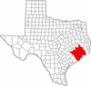 | |
|---|---|---|
| "Principal" cities | ||
| Other cities |
For a complete listing, see list of cities and towns in Houston–The Woodlands–Sugar Land MSA | |
| Unincorporated areas | ||
| Bodies of water | ||
Municipalities and communities of Chambers County, Texas, United States | ||
|---|---|---|
| Cities | | |
| CDPs | ||
| Other unincorporated communities | ||
| Footnotes | ‡This populated place also has portions in an adjacent county or counties
±water surface only; land in adjacent county | |
