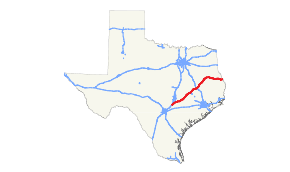
Texas State Highway 21
| ||||
|---|---|---|---|---|
 | ||||
| Route information | ||||
| Maintained by TxDOT | ||||
| Length | 272.7 mi[1] (438.9 km) | |||
| Existed | April 4, 1917–present | |||
| Major junctions | ||||
| West end |
| |||
|
| ||||
| East end |
| |||
| Location | ||||
| Counties | Hays, Caldwell, Bastrop, Lee, Burleson, Brazos, Madison, Houston, Cherokee, Nacogdoches, San Augustine, Sabine | |||
| Highway system | ||||
| ||||

State Highway 21, or SH 21, runs from the Texas-Louisiana boundary east of San Augustine to San Marcos in east and central Texas. SH 21 mostly follows the alignment of the Old San Antonio Road and the El Camino Real, except for the portion between Midway and Bryan, where the Old San Antonio Road took a more northerly route, and SH 21 follows a more direct route. That section of the Old San Antonio Road is served by Texas State Highway OSR.
History

SH 21 was one of the original 25 routes proposed in Texas on June 21, 1917 along a route from the Louisiana border east of St. Augustine to Gonzales, overlaid on top of the Gonzales-St. Augustine Highway.[2] There was proposed extension southward to Karnes City on February 18, 1918.[3] On July 16, 1923, the terminus was shortened to Giddings, with the section south of there being cancelled.[4] A spur, SH 21 Spur, was designated on March 19, 1930 from Milam to Hemphill. On August 1, 1930, this spur became part of SH 87. On September 29, 1933, it extended to Lockhart. On July 15, 1935, this extension was cancelled, and SH 21 was rerouted to end in Lincoln.[5] On October 21, 1936, SH 21 Spur to Chireno was added.[6] On May 18, 1937, the spur in Chireno became a loop, SH 21 Loop.[7] On February 21, 1938, another SH 21 Spur to McMahan's Chapel was added.[8] On April 19, 1938, SH 21 extended to Bastrop, replacing part of SH OSR. On September 26, 1939, the section from Paige to Bastrop was cancelled, as it was already part of US 290. The spur and loop became Loop 34 (Chireno) and Spur 35 (McMahan's Chapel). On August 2, 1943, the western terminus had been extended to end in San Marcos, along its current route.
On June 24, 2010, the SH 21 designation was extended along SH 80 and SH 142 to end at I-35.[9][10]
Business routes
SH 21 has one business route.
Business State Highway 21-H is a Business Loop that runs through Kurten in central Texas. The road was bypassed in 2002 by SH 21.[11]
Major intersections
| County | Location | mi | km | Destinations | Notes |
|---|---|---|---|---|---|
| Hays | San Marcos | 0.0– 0.2 | 0.0– 0.32 | I-35 exit 205; west end of SH 80 overlap | |
| 0.9 | 1.4 | Interchange; east end of SH 80 / SH 142 overlap | |||
| Caldwell–Hays county line | | 6.4 | 10.3 | ||
| | 7.8 | 12.6 | |||
| Hays | Uhland | 9.3 | 15.0 | ||
| Caldwell | Niederwald | 13.9 | 22.4 | West end of FM 2001 overlap | |
| Caldwell–Hays county line | 15.3 | 24.6 | East end of FM 2001 overlap | ||
| Caldwell | Mustang Ridge | 18.0– 18.2 | 29.0– 29.3 | SH 130 exit 461/463 | |
| | 19.0 | 30.6 | |||
| Bastrop | | 25.5 | 41.0 | Interchange | |
| Cedar Creek | 30.3 | 48.8 | |||
| | 34.5 | 55.5 | |||
| | 35.8 | 57.6 | Interchange; west end of SH 71 overlap | ||
| | 37.8 | 60.8 | interchange; west end of freeway | ||
| Bastrop | 39.1 | 62.9 | |||
| 40.0 | 64.4 | Interchange; east end of freeway | |||
| 42.1 | 67.8 | Interchange; east end of SH 71 overlap; west end of SH 95 overlap | |||
| 42.8 | 68.9 | east end of SH 95 overlap; west end of Loop 150 overlap | |||
| 43.5 | 70.0 | East end of Loop 150 overlap | |||
| 43.6 | 70.2 | ||||
| Circle D-KC Estates | 48.6 | 78.2 | |||
| | 55.2– 55.4 | 88.8– 89.2 | Interchange | ||
| Lee | | 62.7 | 100.9 | ||
| | 67.4 | 108.5 | |||
| | 69.5 | 111.8 | Interchange | ||
| | 74.1 | 119.3 | |||
| | 77.8 | 125.2 | |||
| Burleson | | 82.4 | 132.6 | ||
| | 84.8 | 136.5 | |||
| | 88.2 | 141.9 | |||
| Caldwell | 91.4 | 147.1 | |||
| 92.4 | 148.7 | ||||
| 92.6 | 149.0 | ||||
| | 94.0 | 151.3 | |||
| | 98.3 | 158.2 | West end of FM 1362 overlap | ||
| Cooks Point | 99.0 | 159.3 | East end of FM 1362 overlap | ||
| | 103.5 | 166.6 | West end of FM 50 overlap | ||
| Brazos | | 105.0 | 169.0 | East end of FM 50 overlap | |
| | 106.5 | 171.4 | |||
| | 108.8 | 175.1 | Interchange | ||
| Bryan | 112.9– 113.0 | 181.7– 181.9 | Interchange | ||
| 114.2 | 183.8 | ||||
| 115.5 | 185.9 | ||||
| 115.8 | 186.4 | ||||
| 116.4– 116.5 | 187.3– 187.5 | Interchange; west end of US 190 overlap | |||
| Wixon Valley | 121.3 | 195.2 | |||
| | 124.2 | 199.9 | |||
| Kurten | 124.6 | 200.5 | |||
| 125.5 | 202.0 | ||||
| | 130.7 | 210.3 | |||
| Madison | | 134.2 | 216.0 | ||
| North Zulch | 137.9 | 221.9 | Interchange | ||
| 138.1 | 222.3 | ||||
| 138.6 | 223.1 | ||||
| | 146.1 | 235.1 | |||
| | 148.5 | 239.0 | West end of FM 1452 overlap | ||
| | 148.8 | 239.5 | East end of FM 1452 overlap | ||
| Madisonville | 150.4 | 242.0 | |||
| 150.7 | 242.5 | ||||
| 150.9 | 242.9 | ||||
| 152.9– 153.0 | 246.1– 246.2 | I-45 exit 142; east end of US 190 overlap | |||
| Jenkins | 154.5 | 248.6 | |||
| | 155.6 | 250.4 | |||
| | 160.8 | 258.8 | |||
| Midway | 161.8 | 260.4 | |||
| 161.9 | 260.6 | ||||
| 162.2 | 261.0 | ||||
| | 166.1 | 267.3 | |||
| Houston | | 169.8 | 273.3 | ||
| Mapleton | 171.4 | 275.8 | |||
| Austonio | 175.1 | 281.8 | west end of FM 1280 overlap | ||
| 175.2 | 282.0 | east end of FM 1280 overlap | |||
| | 180.0 | 289.7 | |||
| | 187.9 | 302.4 | West end of SH 7 overlap | ||
| Crockett | 188.3 | 303.0 | |||
| 189.0 | 304.2 | ||||
| 189.6– 189.7 | 305.1– 305.3 | East end of SH 7 overlap; traffic circle around Houston County Courthouse | |||
| 189.8 | 305.5 | ||||
| 191.0 | 307.4 | ||||
| | 193.6 | 311.6 | |||
| | 201.4 | 324.1 | |||
| | 208.7 | 335.9 | West end of FM 227 overlap | ||
| | 209.3 | 336.8 | East end of FM 227 overlap | ||
| Weches | 210.8 | 339.2 | |||
| Cherokee | | 220.2 | 354.4 | ||
| Alto | 223.0 | 358.9 | |||
| 223.2 | 359.2 | ||||
| Linwood | 228.0 | 366.9 | |||
| Nacogdoches | Douglass | West end of FM 225 overlap | |||
| East end of FM 225 overlap | |||||
| Nacogdoches | Interchange; U.S. 59 is the future Interstate 69 | ||||
| West end of SH 7 overlap | |||||
| East end of SH 7 overlap | |||||
| Interchange | |||||
| Oak Ridge | |||||
| Melrose | |||||
| Chireno | |||||
| San Augustine | | ||||
| Denning | |||||
| | |||||
| | |||||
| San Augustine | |||||
| West end of SH 147 overlap; west end of Loop 547 east overlap (eastbound only) | |||||
| east end of Loop 547 east overlap (eastbound only) | |||||
| East end of SH 147 overlap | |||||
| | |||||
| Fords Corner | |||||
| Sabine | | ||||
| | |||||
| Geneva | |||||
| | |||||
| Milam | |||||
| | |||||
| | Louisiana state line (bridge over Sabine River (Toledo Bend Reservoir)) | ||||
| 1.000 mi = 1.609 km; 1.000 km = 0.621 mi | |||||
References
- ↑ Transportation Planning and Programming Division (n.d.). "State Highway No. 21". Highway Designation Files. Texas Department of Transportation. Retrieved August 30, 2013.
- ↑ (PDF) https://publicdocs.txdot.gov/minord/MinuteOrderDocLib/003676699.pdf. Missing or empty
|title=(help) - ↑ (PDF) https://publicdocs.txdot.gov/minord/MinuteOrderDocLib/003676752.pdf. Missing or empty
|title=(help) - ↑ (PDF) https://publicdocs.txdot.gov/minord/MinuteOrderDocLib/003676877.pdf. Missing or empty
|title=(help) - ↑ (PDF) https://publicdocs.txdot.gov/minord/MinuteOrderDocLib/003673871.pdf. Missing or empty
|title=(help) - ↑ (PDF) https://publicdocs.txdot.gov/minord/MinuteOrderDocLib/003673892.pdf. Missing or empty
|title=(help) - ↑ (PDF) https://publicdocs.txdot.gov/minord/MinuteOrderDocLib/003673898.pdf. Missing or empty
|title=(help) - ↑ (PDF) https://publicdocs.txdot.gov/minord/MinuteOrderDocLib/003676241.pdf. Missing or empty
|title=(help) - ↑ "Texas Transportation Commission Meeting Minutes, June 24, 2010" (PDF). Texas Transportation Commission. pp. 226–227. Retrieved August 30, 2013.
- ↑ Transportation Planning and Programming Division (2014). Texas County Mapbook (PDF) (Map) (2014 ed.). 1:120,000. Texas Department of Transportation. p. 368. Retrieved December 1, 2014.
- ↑ Transportation Planning and Programming Division (n.d.). "Business State Highway No. 21-H". Highway Designation Files. Texas Department of Transportation. Retrieved October 25, 2010.
External links
![]()